

April 13, 2016: Northbound US 63 at one of the newest additions to Ottumwa’s highway chronology, a three-point roundabout with US 34. This is one of the very few places in Iowa a roundabout kind of makes sense.
Microfilm research isn’t perfect. The best OCR-to-digital transformation of old microfilm still results in photographs looking like crap. And you can forget about color. If, say, a newspaper splurged on green-and-red trappings for Christmas, there’s no way to know about it from the microfilm save for a slightly different shade of gray. But saving the physical copies is expensive, space-consuming, and limited to in-person visits.
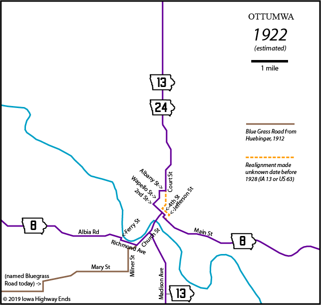
I was doing research for a different upcoming project that caused me to look back at what I did for Ottumwa’s highway chronology. Since then, I got additional resources (namely Huebinger’s Map and Guide for Blue Grass Road). And a hard squint at a copy of a microfilm map made me believe that I had either reversed or mis-dated “present” and “proposed” designations because the original was done in colored pencil. (At the time of this writing, blueprints are unavailable for anything Ottumwa-specific pre-1968, and at least two filesets are blank pages.)
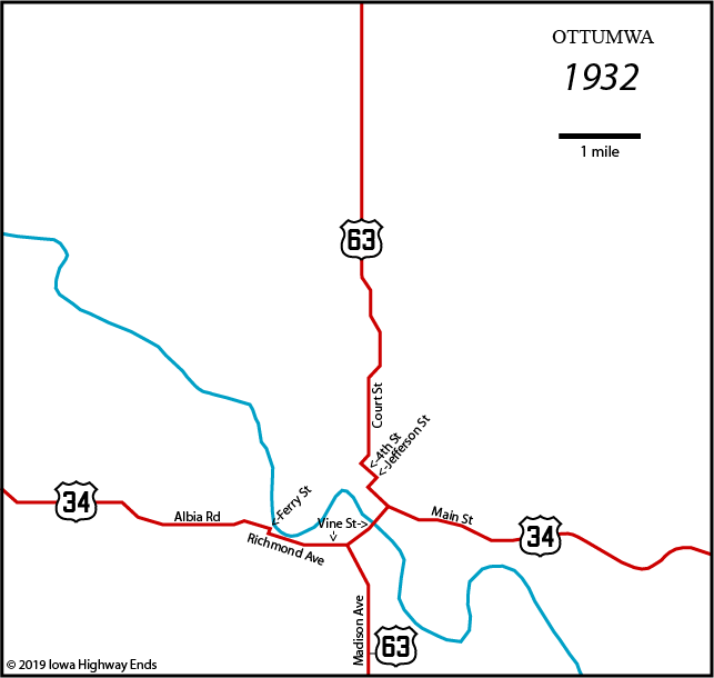
So I killed the 1928 map and made two new ones: 1922 and 1932. It spoiled the “maps on the 8s” theme of the page, but oh well. By splitting them up, I could portray earliest alignments of both the Blue Grass/IA 8/US 34 and the north-south road that was the Cedar Rapids, Ottumwa, and McGregor Trail and today lives on in reduced form as IA 13. There’s one change that I don’t know when it happened, but it’s drawn in as a dotted line.
I also modified the 1938 and 1958 maps to delete Myrtle Street as a connection between Church and Jefferson on the south side of the river, because the highways met in a Y. The connection sliced through the middle of the present interchange. Myrtle could have been used as an unofficial connector, though.
Adding the early maps allows me to illustrate that US 63 is on its fifth bridge across the Des Moines River now, including two from the 1890s. I also was able to list a change that was buried in my notes. That just meant I already had an answer to a question I didn’t know I would ask. Thanks, me!
(Feeling of self-satisfaction immediately negated by realization I wrote Albia where I meant Agency and it’s been that way on the page for a decade. — Ed.)