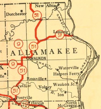
Iowa Highway Commission 1919 map. Notice the absence of a primary road southeast of Waukon and the town of “North McGregor,” which did not become Marquette until March 29, 1920.
IA 51 has never been outside of Allamakee County, but it has a history of intrigue.
Allamakee County, once ranked in a “national amenities index” as the best county in Iowa “from the standpoint of scenery and climate”, is in the heart of the Driftless Area, a section of the Midwest that nearly all the glaciers skipped over. The rolling hills, along with the Yellow and Upper Iowa Rivers, make for many scenic but winding roads.
The route shown above was the initial plan, but based on IHC minutes, appears to have been changed right as the 1920 system was going into effect. The southern portion connected the county’s two largest communities, Waukon and Postville, but the northern portion missed other towns. This proto-IA 51 did not directly connect to any route in Minnesota.
The south half is best described as IA 51, W4B (but not quite), W60, and A52 south of Waukon. Leaving Waukon, IA 9/51 had a big kink using Green Valley Road and A44, and then proto-51 split from 9 following X20. Near the Upper Iowa River, proto-51 turned north on gravel X6A. The 1914 bridge it used across the Upper Iowa River was, according to BridgeHunter, “technologically significant as one of the last of the pre-ISHC trusses in the state” and closed in 2007. Proto-51 used the rest of X6A and met present IA 76 less than two miles south of the Minnesota border.
The first plan to build a road in the Yellow River area (FAP 170) started in 1922, based on a separate plan for the half-mile of road south of Waukon (FAP 169). Although the new route of 51 is drawn on the 1922 map, when this road (W4B between IA 51 and just east of W60) was actually built is murky. There is an item in the Postville Herald on November 6, 1924, referring to “new No. 51 from Postville to Waukon”, but at the same time, “Graveling on No. 51 to start this week” came nearly two years later. To further complicate matters, 1912 and 1914 county maps do not show any road in Section 10 and part of present W4B never gets drawn in on the 1914 map.
The only way to continue east involved sections of what are now Smith Road, Livingood Springs Road and Bethel Road. East of that, there was a pre-existing road (although a bit closer to the river for about a mile in Section 1). While some 1920s state maps look like there was a line all the way to Red School Road, the 1926 project definitively followed present W4B and X16, joining present IA 76 southeast of Waukon.
In and just northwest of Waukon, the revised 51 followed a different route. North of the intersection with Mount Olivet Road, the original is close to but not always present IA 76. For maps of this, see the IA 51 (1920) page.
Notice that the 1919 map did not include a primary between McGregor and Waukon. That road was the last major addition to the system. It was proposed by the Allamakee and Clayton county supervisors in June 1920 and approved by the IHC July 8, handwritten into the minutes. That addition enabled the relocation of the southern half of IA 51.
A portion of this research comes from December 2019 at the State Historical Building. To my surprise and semi-consternation, I was told the only way to get my hands on the minutes was literally to get my hands on the minutes — combing through the original documents (!), tied shut since who-knows-when, three months at a time. Next time — if there can be a next time — I’ll be sure I have more than an afternoon.
