
The Iowa State Fair does not have a redistricting contest. There are no awards for Most Politically Balanced, Fewest Counties, Best District Made With Bacon, etc. Nevertheless, I have a hankering to be the Robin Tarbell-Thomas of submissions.
In my first set of mock districts using 2019 population estimates, my Mock 2 was the third attempt; my second one had just fiddled on the edges of the first making it more of a Mock 1A.
Mock 3: Failure to launch
It is quite easy, or at least it’s seemed easy, to create a district of around 777,500 people plus or minus a thousand. Unfortunately, we’re looking for 788,768, and that last 11,000 or so is really hard to come by. Inevitably the next county to grab is thousands of people above or below that.
Then there’s the other end of the equation. You can get three districts that come in a few hundred under the ideal, and then No. 4 clocks in at 790,000-plus. I managed to make both of these mistakes, along with a third type: Within 200, but a state-border county was left unclicked.
There are certain county pairs that would juuuust about work on the edges, if only their populations switched. The most common cases I ran into were Cedar/Jones, Worth/Winnebago, Ringgold/Taylor, and to a lesser extent the Hardin/Franklin/Butler/Grundy square.
I did a little work thinking about a five-district map, which as I noted in my previous post has gotten much more difficult as Polk and Dallas counties explode in population while most of the rest of the state doesn’t. Polk’s increase alone since 2000 would account for 18% of a single district in a five-set. I would start with Polk-centered districts, but keep running into a block on the northern edge of the southeast district with Benton, Linn, Jones, and Clinton being just too big.
Mock 3 stands in for my busts.
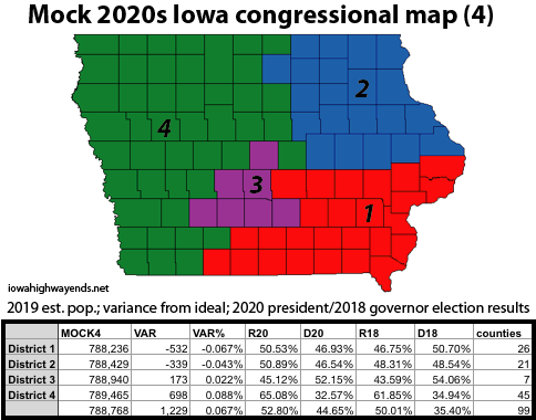
Mock 4: The Marshall County Dangler
District 1: A pretty competitive southeast quadrant resembling with only four counties different than that of the 2010s 2nd (Iowa, Poweshiek, Marion, Ringgold). This would be exceptionally ripe for a rematch of the 2020 2nd District race, and please don’t come after me if it happens.
District 2: Almost a perfect quadrant, and also extremely competitive, filling in a little from the 2010s 1st District and adding Cerro Gordo County.
District 3: I tried really hard to keep Polk and Dallas together, only to not quite get flush on the eastern border. We might be able to come back to this one after the 2020 estimates come out.
District 4: When the LSA creates maps and one county sticks out in some direction, it’s typically connected to the rest of its district by a full county width (see the 1990s map). This has a half-county connection, which doesn’t look great and adds to the perimeter. The most amusing far-down-the-list byproduct of this may be, like in the 2000s, a different congressperson for each of BCLUW’s school buildings.