Apr 22

Luther taking steps toward disincorporation

Months after the old school in Luther was lost to history, the same may be about to happen to the town itself.

The state City Development Board held a hearing regarding Luther’s status earlier this month (PDF). Luther was in the news at the beginning of the year over the fact it could not afford state-mandated sewer upgrades.

Luther’s disincorporation, along with Center Junction’s, would leave 943 incorporated places in Iowa.

Posted in Iowa Miscellaneous | Comments Off on Luther taking steps toward disincorporation
Apr 21

Meetings seek input on Lincoln Highway legacy


September 28, 2014: Art of Youngville Station, inside Youngville Station, on the Lincoln Highway in Benton County.

The Lincoln Highway Heritage Byway group is holding meetings across Iowa to get input on priorities for the future of the historic route, report multiple sources including the Ames Tribune and Clinton Herald.

The Benton County meeting is tonight in Belle Plaine. The Tama County meeting is Thursday in Toledo. Here is a complete list of meeting times from the group.

Posted in Geography, Highway Miscellaneous | Comments Off on Meetings seek input on Lincoln Highway legacy
Apr 20

On legacies, and not being the only one out to visit every Iowa town

Or: Can someone’s thunder be stolen if it isn’t raining yet?

OLYMPUS DIGITAL CAMERA
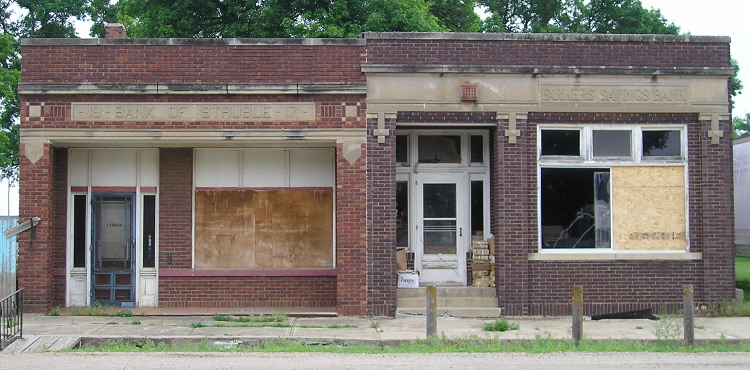
June 5, 2014: Not the only buildings in Struble, but close. Struble, pop. 78, is near the Plymouth/Sioux county line in northwestern Iowa.

I’ve been chugging along in my Iowa highway travels for more than a decade, and am nearly to my goal of traveling every state-maintained route. In a New Year’s resolution, I formalized a goal to visit every incorporated place in Iowa. I figured I’ll have more and better things to say when I got closer to or achieved those goals.

Then BOOM — someone from Keokuk puts up a Tumblr account with a goal to photograph not only every incorporated town, but the unincorporated ones as well — and he gets interviews with Vice magazine* and Kyle Munson. He’s soliciting money from the Internet to do this, something not on my radar for assorted reasons.

Cody Weber and I have different yet similar goals on how we want to photograph Iowa. My first focus has been on Iowa’s highways and their signs. That field, after a static period, is changing in different ways. When I’ve had time, or something caught my eye, I have expanded my range, especially picking up on school buildings and post offices across the state. But I am not as intent on photographing the towns in general. That could be because as a lifelong Iowan, I’m used to seeing sparse small-town downtowns. It could be because I am doing all this with a 10-year-old point-and-shoot camera. Mostly, I’m guessing it’s not spending as much time in any one place as a project like Weber’s requires.

As Weber has found out, engaging in a project that captures disappearing rural Iowa runs the risk of ruin porn. Of course, I am not above that at all — many school pictures fall under that category, as does the photo at the top of this entry. If something like this is going to be done, don’t let it be as a drop-into-flyover-country report — although Weber told Vice he plans on leaving Iowa when he can.

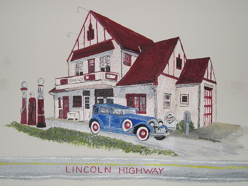
Unlike Weber, I would love for my legacy to be Iowa. If my highway pages, city highway histories, and school district timeline have benefited others, I am thrilled (with bibliographical acknowledgement as necessary). I have occasionally wondered what I can do with the photos I have taken — perhaps get a book published, like Dave and Barb Else did with schools, or Carson and Connie Ode did with their 99-county yearlong tour. I have already left little marks with my Des Moines Register columns about the Lincoln Highway and the closure of the Manilla school. The Iowa Office of the State Archaeologist took 7,000 photos of towns in six years, and I could augment that collection, eventually. I went across Iowa’s Lincoln Highway route in its centennial year, and that would be one category rich for visual storytelling.

I am the first to admit that my collection is esoteric. At the same time, though, I think it can be valuable precisely because it is esoteric. There is plenty of time to think about that legacy. For now, I am content to do what I can with what I have — but a dedicated webpage or two on this site probably wouldn’t hurt. (Not Tumblr. I can’t stand Tumblr’s structure.)

*Why Vice? Weber’s non-Forgotten-Iowa photographs have a Williamsburg vibe, and I’m not talking about the home of the Raiders.

Posted in Iowa Miscellaneous, Maps | Comments Off on On legacies, and not being the only one out to visit every Iowa town
Apr 18

Nothing happening in Ames today

Nothing at all.

noveishea

Posted in Iowa Miscellaneous | Comments Off on Nothing happening in Ames today
Apr 17

Central Clinton executes stealth name change

The district in eastern Iowa that is most often called “Central Clinton,” and has a website as as “Central Community,” appears to have filed a name change with the state Department of Education last calendar year.

The kinda-sorta-less-vague-yet-not-really name change to “Central DeWitt” follows an encounter with the limited-character scoreboard at Wells Fargo Arena during the 2014 state boys’ basketball tournament*, where it was labeled “CCLINTON.” Being “Central” by itself is even more vague, and we already have a Central Community School, in Elkader, and of course both of them are “central” only in their respective counties.** I guess it will be “CDEWITT” on the scoreboard next time, which is probably the biggest place this change is going to matter.

The name change is discoverable through the education department’s running list of district reorganizations and databases related to the current school year, including certified enrollment. There were news articles, but no indication anything had been done about it.

The district will retain its code number. It was already alphabetically ahead of Central City for whatever reason, but the numbering system has some flubs that date back to its creation in 1993 since Central Lee is ahead of all of them.

In the end, Grand Mound, Low Moor, and Welton are chopped liver, and now the question is “If you’re in De Witt, what are you central to?”

*Why that box score text is dated 2016, I don’t know, unless I’ve stumbled through an Internet wormhole.
**Why isn’t that district Central Clayton?

Posted in Schools | Comments Off on Central Clinton executes stealth name change
Apr 16

Information on Council Bluffs construction for 2015

Last week, the DOT held a public meeting about construction plans for this year in the Council Bluffs interstate system. We’ve already had years of construction and aren’t halfway through. Only five of the 32 planned bridges have been completed, reports the Daily Nonpareil, and one of those is the I-29 southbound flyover ramp to I-80 eastbound.

A multi-part video from the meeting is available at the DOT’s Council Bluffs Interstate website. As far as I can tell there is no “play all” option for the very short clips. Some panels have informative slides.

Posted in Construction | Comments Off on Information on Council Bluffs construction for 2015
Apr 15

Jasper County bridge replacement prepares for six-lane I-80

Preparation for an eventual upgrade of I-80 to six lanes east of Des Moines, which at the moment has no timetable, was first manifested in new bridges over the Cedar River. Now it’s time to replace bridges over the Skunk River, and the Iowa DOT is planning on doing the same thing.

Six-laning I-80 will require relocation of the main travel lanes. We’ve already seen this in action on I-35 in Warren County, north of and at IA 92. New lanes will be constructed alongside the old ones, but two lanes for right now. The new bridges will be three lanes wide.

The documentation (PDF) shows a four-year process at the Skunk River. A gravel-road bridge over I-80 will be removed.

Posted in Construction | Comments Off on Jasper County bridge replacement prepares for six-lane I-80
Apr 14

School expansion, demolition in Midland district

The Midland junior/senior high school in Wyoming has an awkward setup: two separate complexes across the street from each other. The 1914 building was kept by itself while an entirely new building was constructed in the mid-20th century (before the 1950s aerial photos) and that building was the one that got later additions.

Now, after closing all auxiliary sites except the elementary in Oxford Junction, Midland is going to build another school around the “younger” one. The plan (PDF), approved in last week’s bond referendum, uses the existing building as a core while glomming on a second gym and a two-floor expansion (PDF). The 1914 building will be demolished in summer 2017, according to the plan.

Posted in Schools | Comments Off on School expansion, demolition in Midland district
Apr 13

AHSTW staying AHSTW after consolidation

A proposed consolidation of the AHST and Walnut school districts next year would result in … the AHSTW school district, the Council Bluffs Nonpareil reported last month.

The new district, which would erase one of the straighter boundaries out there today, would be a continuation of the recent whole-grade sharing agreement between the two old districts and span nearly 20 miles along I-80 in western Iowa.

The photo with the Nonpareil story says Walnut will still house an elementary school, but an Omaha World-Herald story from February indicated the building could be sold to the city.

(And yes, I am pleased with this development.)

Posted in Schools | Comments Off on AHSTW staying AHSTW after consolidation
Apr 12

I-41 official in Wisconsin


May 13, 2010: US 41 will be removed from these signs at the Marquette interchange and on its short stretch of surface road in Milwaukee in order to run concurrent with the new Interstate 41.

Another 175 miles of interstate highway (140 new), and a moderately annoying numbering situation, have been established in the Midwest.

On April 9, Interstate 41 was officially born, running from just south of the Wisconsin-Illinois state line to Green Bay. It will “replace” US 41 for that entire length, including a duplication with I-94 all the way south of Milwaukee. According to documentation from the Wisconsin DOT, US 41 will not be signed at interchanges and will only exist as a reassurance shield on the mainline after each exit. It can’t be completely decommissioned, since it continues all the way up to its historic end at Copper Harbor, Michigan. (It is an improvement over Arkansas’ complete disavowal of US routes co-signed with interstates, though.)

The numbering systems for north-south interstates (working west to east) and US highways (working east to west) crash into each other in Wisconsin, especially after the creation of Interstate 43 in the 1980s. With a position between I-39 and I-43, the duplication of I-41/US 41 was not inevitable yet a logical outcome given the constraints. (Wisconsin has US 51 and US 53; I-55 and I-57 are lengthy interstates in Illinois.) The corridor has been “Highway 41” for nearly a century now; it will continue to be “Highway 41” no matter the color of the shield.


June 14, 2008: The new I-41 will be added to the right sign at the I-43/894 split southwest of downtown Milwaukee. A US 41 shield might not be included, however.

That said, the redundancy with I-94 south of Milwaukee and continued existence of I-894 in Milwaukee are absurd. The only way it would not be absurd is if the exit numbers were changed to count up heading north since there’s now a north-south interstate. But look just to the west, where I-90’s numbers rule despite the northward extension of I-39, and you can see that’s just not going to happen. The third number in Wisconsin’s second interstate triplex, I-894, stays as the east-west number of an east-west freeway and those exits probably won’t be renumbered either. It’s going to be a wrong-way triplex just like in Cedar Rapids — east will be NB I-43 and SB I-41; west will be SB I-43 and NB I-41.

The red-white-and-blue I-41 shields will not be posted or uncovered until this fall, the press release and a December report from WLUK-TV said. Appleton, Fond du Lac, and Oshkosh, the only cluster of cities their size so far from an interstate, finally get their wish after years and years of work.

Wisconsin ceases to be one of my “clinched interstate” states and I have a future trip to plan. (By the way, Tim, WHERE ARE YOU?)

Posted in Highway Miscellaneous, Maps | Comments Off on I-41 official in Wisconsin