Aug 07

‘Tidings from Traer’


August 9, 2008: The north side of Traer’s business block was constructed after a fire in 1894 burned the whole thing down.

Toledo Chronicle, August 7, 1873:

The town of Traer, the present terminus of the Pacific branch of the B.C.R.&M. R.R., is growing with wonderful rapidity. There are now sixteen business buildings nearly completed, and ground has been broken for several others which will be finished as early as possible.

Rev. Mr. Gilbert, pastor of the Buckingham Congregational Church, preached in the grove last Sunday, and it would have been in order for him to have opened his discourse with the customary “in hac sylva congregamus.” It speaks well for the morale of the new “railroad” town that divine service should precede the erection of a suitable building. As a greater evidence of the moral status of the people it may be added that, no spiritous liquors are allowed to be sold on Sunday at that place.

The Wolf Creek Post-Office has been moved to the town, and a petition for a change of name from Wolf Creek to Traer has been extensively signed. Miss Zoe Taylor is postmistress, having been appointed about July 1st.

Posted in Tama County | Comments Off on ‘Tidings from Traer’
Aug 06

The Big 12’s expansion, copy-edited

An unemployed copy editor is a hungry copy editor. The news story on Cyclone Fanatic about Big 12 expansion provided a buffet. This is done with Adobe Acrobat’s markup tools, although I used the old-school “remove character” mark for visibility.

A portion of Pollard’s statement is omitted here for space reasons.

Posted in Sports | Comments Off on The Big 12’s expansion, copy-edited
Aug 04

The Iowa State Fair: An appreciation

My latest Substack column is about something I love.

I admit that after going 0-for-3 in job interviews over five weeks, I’m not feeling the last sentence I wrote for it right now.

Please subscribe, with money if you feel like it.

Posted in Iowa Miscellaneous | Comments Off on The Iowa State Fair: An appreciation
Aug 02

IKM-Manning trying again on bond issue

For the third time in four years, the IKM-Manning school district is trying to close the building in Irwin by building an addition in Manning.

At a meeting in July, the board approved a vote for November, the Carroll Times Herald reported. An official cost has not been established, the paper said. I couldn’t find a plan for 2023, but the 2020 plan is still online at the time this post was written. That flyer showed a second gymnasium that could be converted into two courts, a library, locker rooms, science rooms, and many classrooms. (We can tell it’s the 2020 plan because bond votes are no longer allowed in September.)

Earlier this year, district voters approved using state sales tax revenue, which is not a general obligation bond, for improvements at the school in Manning. Vote totals posted on KCIM’s website show that while Carroll County (Manning) voted 19-to-1 in favor, Shelby County (Irwin) and Crawford County (Manilla) were split about 50-50, tilting toward no. Weirdly, the Shelby County Auditor’s Office only has vote results from 2000 to 2011.

In 2020, the bond referendum had a 55-45 majority, but that was not a supermajority. In 2021, the referendum failed by 84 votes. Carroll County again overwhelmingly voted in favor while everywhere else voted nearly 3-to-1 against, according to results posted by KJAN. (Note that the URL indicated a successful vote, but a final canvass showed that was not the case.)

Posted in Schools | Comments Off on IKM-Manning trying again on bond issue
Jul 31

100th anniversary of Reed-Niland corner in Colo


July 5, 2013: The Colo Motel at the Reed-Niland corner.

In 1923, a Colo farmer began a gas station at the east junction of the Lincoln and Jefferson highways. The station, which expanded to include a restaurant and lodging, thrived for decades. In the past 30 years operations at the cafe have been off and on, but they are currently on.

Prairie Rivers of Iowa has an article chronicling the history of the corner, its ownership, and its place in Iowa and national highway history. The corner was the site of the first grade-separated intersection in Iowa as the Jefferson Highway, later US 65, joined/left the Lincoln Highway here.

On Saturday there will be a 100th anniversary celebration. There will be live bands and food will be served.

Posted in Highway Miscellaneous | Comments Off on 100th anniversary of Reed-Niland corner in Colo
Jul 28

Pottawattamie County supervisor plan goes up for vote

On August 1, Pottawattamie County is going to find out if its current county supervisors plan is going to change.

The county currently has five supervisors elected on an at-large basis. The groups that led the petition drive to change it, according to KETV, want district-based representation where each candidate must live in the district and only that district votes.

Iowa Starting Line says that four of the five supervisors live in the western half of the county, two of those in Council Bluffs. Stories from both KETV and WOWT show that a likely district map would concentrate four of the five supervisors in Council Bluffs, while the rest of the county only gets one.

Similar representation issues have come up in Johnson County, but in the other direction. One Pottawattamie supervisor said this vote is “their plan B to get to get Democrats on board.” In Johnson, meanwhile, Republicans have won one supervisor seat in half a century, in 2013. It was a special election in a snowstorm with under 7% turnout.

UPDATE 8/9: No change.

Posted in Iowa Miscellaneous | Comments Off on Pottawattamie County supervisor plan goes up for vote
Jul 27

MMMFW

I have explored the most infamous headline in Iowa history: “Manly Man Marries Fertile Woman.”

Read, like, subscribe, etc. over at my Substack.

Posted in Iowa Miscellaneous | Comments Off on MMMFW
Jul 25

Tama-Toledo RAGBRAI maps available


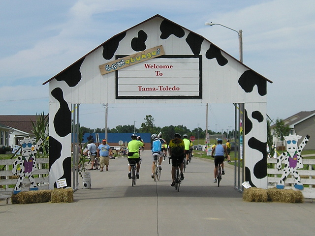
July 23, 2008: Riders enter Tama on RAGBRAI XXXVI. Tama-Toledo is again a host community this year.

RAGBRAI will be going from Des Moines to Tama-Toledo on Thursday, and highs are expected to be in the upper 90s. By the official map, riders will not have had a pass-through town since Grinnell, but the ride will graze the corner of Montour. Maybe there will be a water stop of some sort there.

I wasn’t going to post anything specific to the ride this week, having covered the map beforehand here and also here. I was also waiting for official town maps to be posted, and then (gestures upward at sticky post).

The town maps are up now at the official overnight stop website. It’s unfortunate that the Lincoln Highway bridge, featured in the logo, is not in condition for riders to go over. It may never be again, but that’s a blog post draft that isn’t ripe yet.

The rider information page is here. The Google map is here. Try as I might, I could not get the static maps to show up full-size, and then I tinkered with the hyperlinks.

HERE is the Tama-Toledo overview map. Bikes will come in on E49, US 63, Business 30, Broadway, and Ross Street, splitting off along the way to various campgrounds. The South Tama school campus will be the main campground. (“Elementary Echool”? You guys could have had someone proofread your stuff for cheap. Just saying.) There will be three bus routes circulating through the towns.

HERE is the entertainment map at Toledo Heights Park. There are nearly three dozen vendors, including the Tama County Cattlemen and Rube’s Steakhouse (!). Many will be lining the edge of the infield of one of the ball diamonds. That’s Business 30, not the Lincoln Highway, on the south edge. There is also a stage in downtown Tama, where a band called Lincoln Highway will play at 3:30.

NOTE: There is no left turn from eastbound US 30 to Business 30 due to construction. The US 63 exit will be closed.

HERE are detailed notes for residents about which streets will close and which will be open. The Friday information says US 63 will be closed from E29 to E69, and if that is the case that’s a 16-mile stretch from the Garwin corner south to nearly the county line. Riders will head out of Tama to the south and turn at E64 (Sandhill Auto Salvage).

Further along the route, Belle Plaine’s June newsletter said the Iowa State Patrol will begin shooing riders out of that town by 12:30. That day ends in Coralville (S.T. Morrison Park) via the Amanas.

Posted in Tama County | Comments Off on Tama-Toledo RAGBRAI maps available
Jul 24

Sandblasting, new paint for Winding Stairs


July 9, 2023: Crop of a picture of the Winding Stairs, before cleaning.

On July 16, Traer’s iconic Winding Stairs had a refreshment. It wasn’t a drink, but a full-on sandblast followed by a new coat of paint.

The North Tama Telegraph has the story, along with information about restoring the building the staircase is attached to. That building, of course, is the Traer Star-Clipper building, which housed the newspaper offices until 1954.

Some local yokel happened to have their picture taken on the stairs the Sunday preceding the cleaning for a writing venture. The introductory post was included in the Iowa Writers’ Collaborative “roundup” on Sunday. (Like! Subscribe! Tell your friends and enemies!) The photo didn’t appear, which is fine with me because the fewer pictures there are of me on the Internet, the better.

Posted in Tama County | Comments Off on Sandblasting, new paint for Winding Stairs
Jul 21

Here comes the I-35 flyover ramp


The “Stage 3A” plan for the northeast mixmaster includes this sign on eastbound I-80. The present gantry has the BGS for the left exit on I-35 with a 45 mph limit.

What has been perhaps Iowa’s most notorious left-hand interstate exit — and after the the past 15 years of construction, one of Iowa’s only remaining left-hand interstate exits — is going away soon.

If you’ve driven past the northeast mixmaster recently, you’ve seen construction of bridge pillars for a big flyover bridge for northbound I-35 from eastbound I-35/80. The paving plans for that bridge are part of the July lettings this week, along with a signage plan whose overview diagrams made my laptop squeal with pain.

This part of the project also includes an entirely new ramp for northbound I-35 from westbound I-80, farther away from the center of the interchange than the current ramp is. A new ramp from eastbound I-80 to eastbound (southbound) I-235 will be joined with the flyover. That’s where the above BGS image comes in. Eastbound I-35/80 will have a single exit point that then forks into 35 across the flyover and 235 on the southwest side of the interchange.

The new sign uses long “ahead” arrows instead of down-pointing arrows, a sign standard from the Manual of Uniform Traffic Control Devices. The MUTCD is being updated this year. I disagree with this change; I think pointing down for the thru traffic (kind of like a “stay in this lane” message) with an arrow for exiting traffic (a “go here” message) made more sense.

I am surprised, given the space available, that Chicago was not added as a second control city for eastbound I-80. Perhaps there’s still time to add that in the final product.

Posted in Construction | Comments Off on Here comes the I-35 flyover ramp