May 08

‘Tama Jim’ featured on ‘Market to Market’

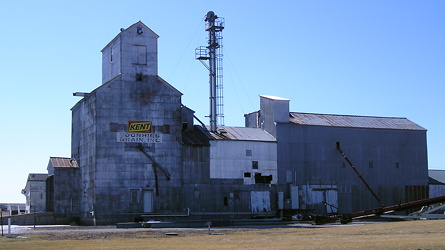
Iowa PBS’s “Market to Market” show did a 6½-minute feature on “Tama Jim” Wilson last week. Wilson, originally from Scotland, came to the Traer area before the Civil War and eventually became Secretary of Agriculture under three presidents.

I’m going to embed the video, but based on previous experience it’ll still require going to YouTube.

Posted in Tama County | Comments Off on ‘Tama Jim’ featured on ‘Market to Market’
May 05

Clearing up Clearfield

Following a reader’s letter, I dug in on the history of the Clearfield school for the 1982-92 school years. It got so complicated I had to make a spreadsheet. The Clearfield district, on the Taylor/Ringgold county line, dissolved in 2014.

  • I was a year off on Clearfield’s last year for a high school; it was 1983-84 (Mount Ayr Record-News, 5/17/84). In that year, Clearfield and Diagonal had a junior high sharing arrangement, with seventh grade in Diagonal and eighth grade in Clearfield (MARN, 4/21/83).
  • For 1984-85, grades 5-9 were in Diagonal and 9-12 in Clearfield except for physics, chemistry, and shop classes in Diagonal (MARN, 2/16/84). That was reversed for 1985-86, with 6-9 in Clearfield and 10-12 in Diagonal (MARN, 4/11/85).
  • Clearfield switched to sending all students in 9-12 to Lenox for one year, 1986-87 (MARN, 12/26/85). The high school situation remained unsettled and ended up in a “first of its kind” program that allowed students to go to Diagonal, Mt. Ayr, or Lenox (MARN, 6/25/87). This arrangement appears to have remained in place despite various feints toward other combinations (Lenox Time Table, 7/1/87; LTT, 10/9/94; LTT, 4/23/97). 
  • Probably not helping: A superintendent quitting after one year — and announcing it on July 30 (MARN, 8/7/86).
  • Diagonal stopped sending grades 6-8 to Clearfield in 1991, resulting in Clearfield extending its three-way-split open enrollment to grades 7-12 (MARN, 1/24/91).
  • At one point, a Clearfield-Lenox deal died for, among many other things, “political and social problems between the two school districts” (Clearfield Chronicle, 11/2/94).
  • This does make the crazy-quilt carve-up of Clearfield in 2014 a little more understandable. The extension of the Diagonal district into the town of Clearfield itself by using 170th Street came late in the process (Diagonal Progress, 7/25/13).
Posted in Schools | Comments Off on Clearing up Clearfield
May 03

Peyton Manning, call your office

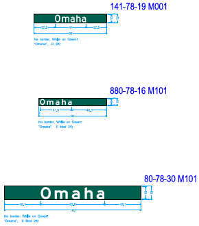
The above image comes from an Iowa DOT sign letting contract that is to be let May 16. The contract covers sign trusses and BGS replacement at four key interchanges: Both ends of I-880 and IA 29 at old IA 192, plus IA 191 at I-880.

Many of the BGSs are getting a complete replacement. This will eliminate the overlaid I-880 shields over the I-680 shields, and also remove the hole for IA 192 on SB I-29 at Exit 57.

Some smaller signs, though, including the relevant ones at IA 191, are getting a greenout overlay. The designation of “Omaha” will replace “North Omaha”. That name has been used since the signs were originally put up, or in the case of the exit near Shelby, after an extension of I-680 replaced I-80N. This project does not include the signs at the Logan/Beebeetown exit or on westbound I-880 at I-29, so “North Omaha” isn’t completely gone yet.

(I still disagree with the redesignation of part of I-680. Bleah.)

Posted in Construction | Comments Off on Peyton Manning, call your office
May 01

Truss no one


June 19, 2021: The underside of the Iowa approach to the old I-74 bridges.

Deconstruction continues on the I-74 Mississippi River bridge following the decision last year not to bring it down with explosives.

WQAD has a story about the dismantling process, which is expected to last another year. Underneath that story is a video about the demolition of the old Rock Island County Courthouse at the foot of the Centennial Bridge.

KWQC has a collection of photos from the Iowa DOT of the current status of the bridge. The roadbed has been removed entirely, leaving only the metal beams and superstructure.

Posted in Construction | Comments Off on Truss no one
Apr 28

Fort Madison cuts sports sharing, then reverses course

When the Fort Madison school district voted to end its sports sharing programs early this month, it got the governor’s attention.

The public school had been sharing multiple programs with students from Holy Trinity, and wrestling to Central Lee. In a statement issued by the school at the time and reprinted by the Fort Madison Daily Democrat:

In January, Governor Reynolds signed a bill making state education funding that had been designated for public schools available for students attending private schools. That dramatic shift, engineered by state lawmakers, has caused many schools in Iow[a] to reconsider their sharing agreements as private schools now have more resources to fund their own athletic programs.

The following week, the governor responded. From the Pen City Current:

The law also provides $1,205 “backfill” per student to the public schools for every student in the district that is enrolled in a private school. That funding would begin in the next school year, according to state officials, and would amount to $355,000 per year in additional funding for the Fort Madison district.

Reynolds said if the district is going to punish the kids, then maybe the state should look at allowing the $355,000 to follow the students as well, to help offset the costs of the athletic programs.

The day after that (late Thursday, April 20), Fort Madison and Holy Trinity were re-engaged in talks for sports sharing. Fort Madison’s school board president told the Daily Democrat the governor’s comments were a non-factor.

Earlier this week, Fort Madison in a special meeting approved a sharing deal with Holy Trinity where the latter would pay a $20,000 annual fee to the former, said the Current.

Posted in Schools, Sports | Comments Off on Fort Madison cuts sports sharing, then reverses course
Apr 26

Taking a run through every town, updated


March 19, 2022: Unincorporated towns on the Iowa map include Voorhies, in the southwest corner of Black Hawk County.

About a year and a half ago, I ran a blog post about Tyler Sullivan, who is doing the every-town thing on the extremely difficult level. Not only is he including unincorporated places, he’s writing a poem about each one as he goes through.

KCCI has a four-minute profile on Sullivan after he started his set for 2023. In the interview, he gives a number about 200 more than he told the Estherville News in summer 2021. He told KCCI he has “a little more than 1200” places to visit overall. My rough count is 941 incorporated and 239 unincorporated on the state map, which would be 1180. This number is flexible and hard to pin down, illustrated by the inclusion of Adaza northwest of Churdan, which is not on the state map, and then you have Census-Designated Places that aren’t on the map and some gated resort areas that are.

I would be terrified of doing all that while holding a phone in my hand.

Posted in Iowa Miscellaneous | Comments Off on Taking a run through every town, updated
Apr 24

Malvern’s ‘End 41’ found a new home


March 13, 2002: The only photo this site has of IA 41’s south end before decommissioning, taken by Neil Bratney.

IA 41, a spur to Malvern, was an original 1920-series highway that was killed off in the Second Great Decommissioning of 2003. However, one little reminder remains in town.

The Classic Cafe has the “End 41” from the route posted on a wall inside. You can see it in the background at the 1:28 mark in this story from WOWT about the cafe suffering severe hail damage in a thunderstorm. Southwest Iowa and southeast Nebraska were hit hard by hail on the night of April 19, and KETV says phones at one Omaha glass shop are ringing off the hook.

The Classic Cafe righted one wrong on the signage: It properly displays “End 41”, rather than “41 End” as was posted in the last years of the highway’s life.

Posted in Highway Miscellaneous | Comments Off on Malvern’s ‘End 41’ found a new home
Apr 21

Pomeroy school’s future unclear

Pomeroy-Palmer merged with Pocahontas Area a decade ago. The building in Pomeroy has been vacant nearly as long, except that the gymnasium has remained in use for practices*. But Pocahontas Area doesn’t want the facility anymore, KCCI reports, and the city of Pomeroy has been given 90 days to determine whether the building will become city property or be torn down.

Pomeroy currently has a small community center near downtown on the north side of town.

*Headline in tab said “School building used for practice gym faces uncertain future”.

Posted in Schools | Comments Off on Pomeroy school’s future unclear
Apr 19

US 30 bridges in C.R. under construction

Now for the worst kind of construction update, the kind that affects me: Bridge deck overlay projects in a couple spots on US 30 in Cedar Rapids west of I-380 will reduce freeway traffic to one lane in both directions. The work is expected to last about three months.

The DOT press release about it seems much more … chattier? … than the usual nuts-and-bolts stuff. The on-ramp from 6th Street SW to westbound 30 will be closed, and the linked detour map is of the type that customarily appears in the project lettings. The detour uses 60th Street SW and Edgewood Road.

Posted in Construction | Comments Off on US 30 bridges in C.R. under construction
Apr 14

RAGBRAI L map notes and analysis


July 29, 2021: RAGBRAI riders enter Center Point. RAGBRAI was not held in 2020, so 2023 marks the 50th ride. (The plague ended a lot of continuous/consecutive records.)

My analysis (with passing corrections) of the RAGBRAI L map is based on what I saw on the full route reveal page as of April 5. See also this somewhat analytical post on how RAGBRAI L can still count 50 communities along the ride.

  • Day 1 is identical to Day 1 in 1973. This general, but not exact, route was last followed in 2015.
  • Between Early and Lake View, 255th Street is D36 and Perkins Avenue is M68 – these designations don’t pop up on Google Maps for some reason.
  • The route between D36 (old US 20) and E16 has never been used.
  • Using US 30 (not IA 30) between Carroll and Glidden is a first, and the first time any rural segment of US 30 has been included.
  • The segment east of Jefferson to IA 144 is still E53, and again, unmarked on Google. Ditto for P54/Clover Avenue, which goes through Berkley.
  • E57 between P54 and R26 has never been used. Neither have IA 17 and old IA 415 between Madrid and Polk City. The first route from Ames to Des Moines was completely different south of Slater, including entering on NW 6th Drive (1973) vs. US 69/NE 14th Street (2023).
  • The route heading out of Des Moines to Mitchellville hasn’t been used before, including NE 72nd Street (not Avenue), which technically is 1st Avenue S in Altoona.
  • After Colfax, save for going through Iowa City and Davenport, the 1973 and 2023 routes in the eastern half of Iowa have nearly nothing in common. That’s due to needing another day along the way.
  • US 6 between Newton and Kellogg has never been used. Neither has the Grinnell to Montour segment, V18 from E64 to Chelsea, or IA 212. Another part was only used in 1979: E64 from US 63 south of Tama to V18.
  • Tama-Toledo last hosted in 2008, and RAGBRAI was last in Tama County in 2012.
  • East of Iowa City is half a Google Maps “tell”, half a Johnson County contortion. Old 6 east of Iowa City shows up as F46 on the state map and one sign (but not on US 6 itself at the intersection), despite county maps showing the F46 designation going east on gravel 400th Street (Johnson)/310th Street (Cedar). Google marks part as X16, but the county map doesn’t. The entire segment from Iowa City to US 6 is American Legion Road, and Johnson County needs to figure out what alphanumeric name it really is. (I suggest designating the whole paved road F50.) Then the ride route follows US 6 to West Liberty. None of this segment has been used before.
  • IA 70 is the north-south road heading south of West Liberty, but then it’s IA 22 east to Muscatine.
  • Except for a few miles west of Montpelier in 2018, IA 22 between Muscatine and Davenport has never been used.
  • Better luck next time (again), Bettendorf?
  • First-timers: Berkley (which, although not starred, has the ride inside city limits) and Buffalo
  • Been-a-long-timers: Glidden, 1981; Kellogg, 1991; Breda, 1994; Rippey, 1994; Ankeny, 2000; Madrid, 2001
Posted in Maps | Comments Off on RAGBRAI L map notes and analysis