(July 1, 1920-July 22, 1939)
- In 1920, they knew it as: From Council Bluffs to Avoca and Des Moines to Davenport, the River to River Road. But between those two locations, it departed significantly from the R2R. Between Avoca and Guthrie Center, it followed straighter roads via Harlan, and then between Guthrie Center and Des Moines it followed the Panora Speedway, a straight shot connecting the two via Grimes. The R2R was not registered until April 16, 1918, but existed as early as 1910, when Huebinger's Map and Guide for River to River Road was published. Three years later, the Detroit, Lincoln, and Denver Highway piggybacked onto the original R2R and Omaha-Denver Trans-Continental Route. (12 counties)
- This is a westward continuation of IL 7.
- The below will not count the 7½-month swap with IA 2 (I) in the western half of the state in 1922-23, although that's the route that would become US 6 in late 1926.
- We know it as: Broadway (old US 6) in Council Bluffs, G8L (old IA 191), G18 (old IA 83), US 59, IA 44, the roads as show on Jason Hancock's Highways of Des Moines page, and US 6 (pre-interstate move) east of Altoona, including old 6 between US 63 and west of Ladora.
- Let's get granular:
- Council Bluffs: Broadway, Oak Street (now a pedestrian walkway), Pierce Street, Canning Street (now a dead end), Kanesville Boulevard
- Council Bluffs to Underwood: G8L, 205th Street, Homestead Avenue, L34, Idlewood Road, G8L, Weston Avenue, Juniper Road, Jaguar Loop, abandoned diagonal (follow farm line), Magnolia Road
- G8L, former IA 191, is also known as Railroad Highway. As you can see by this list of names, not all of it hugged the railroad.
- Underwood: vacated running north from Mulberry Lane at the Underwood truck stop into Milwaukee Avenue, 2nd Avenue, 1st Street, G30
- Underwood to Neola: 265th Street (now broken), Pinoak Road, G8L, a thin scar you can partially see going north and east from 280th Street, 285th Street, 290th Street, Shortstop Avenue, G8L, 2nd Street in Neola, vacated road on east side of railroad that rejoined G8L in 1/2 mile
- The short segment on the wrong side of the railroad has left a trace to this day — the curves of IA 244 (1980-2003).
- "Neola Auto Co. Agents for Maxwell, REO & Ford cars. Autos for sale, auto repairing, auto livery, auto supplies and repairs." — Huebinger's R2R Guide
- Neola to Harlan: G8L, G18, 340th Street (dead end), west and east vacated extensions of Westgate Road that meet 83 at 350th Street, IA 83, Elm Street in Avoca, US 59, 450th Street, Maple Road, F58, northward vacated extension of Juniper Road, 700th Street, US 59, 800th Street, Linden Road/12th Street
- The east-west segment at F58 passed through the village of Corley. Then it turned north through what's now the Harlan airport. This row of sections, just west of the survey correction line, is actually 1½ miles tall.
- Southwest Avenue, a curve that enabled IA 7 traffic to avoid two crossings of the Chicago & Great Western Railroad, was built in 1930.
- Harlan to Guthrie Center: IA 44, with the following exceptions:
- A hard corner at 1000th Street and M56 (the village of Jacksonville, populated today mostly by grain bins), and a mile south
- A wiggly road east of Kimballton, about half of which remains today as part of Sharon Road
- 235th Street and Lark Avenue a mile east of Hamlin
- Guthrie Center to Grimes: 13th (partially vacated by late '30s) and Bluff streets on the east side of Guthrie Center, IA 44, Roost Lane corner west of Panora, IA 44
- The west end of the Panora Speedway was a block south of the courthouse, today the intersection of IA 25 and 44.
- Guthrie Center replaced its north-south street names with numbers in 1939. Church became 5th and Spruce became 13th.
- An alternate route through downtown Dallas Center used Percival, Walnut, and 11th streets.
- Grimes to downtown Des Moines (1920-late 1924): NW 70th Avenue, NW 86th Street, NW 62nd Avenue, Merle Hay Road, Douglas Avenue, Beaver Avenue, Forest Avenue, 31st Street, University Avenue, 28th Street, Cottage Grove Avenue, 19th Street, Woodland Avenue, 12th Street, Grand Avenue
- Moving to 86th and 62nd, instead of staying on 70th to Merle Hay Road like the Panora Speedway did, avoided a railroad crossing but also took it farther from the "Hyperion Field & Motor Club".
- This route would have gone past the Drake University campus. Between Forest and University, 31st now dead-ends in favor of a curved 30th Street.
- Grimes to downtown Des Moines (late 1924-1939): Merle Hay Road, Douglas Avenue, Beaver Avenue, Forest Avenue, 21st Street, Carpenter Avenue, Keosauqua Way, 7th Street
- Per Jason Hancock: "The block of Keo Way between 8th and 7th Streets downtown was removed in 1993 to make room for a Principal Financial Group office building."
- Both Keo Way and Hubbell Avenue were built in 1924, making them ineligible to be on the "original" route.
- Downtown Des Moines to Altoona (1920-24): Grand Avenue, either East 12th and Walker streets or East 18th Street, Easton Boulevard, East 42nd Street, NE 38th Avenue (renamed Douglas after recent annexation), NE 46th Street, Broadway Avenue/8th Street SW (Altoona)
- The either/or is the River-to-River Road vs. the route more likely by 1920.
- Walker between East 12th and East 13th has been taken out for an addition to East High School. The once-intersection of Walker and East 18th is buried under the strings of I-235 and ramps between East 15th Street and University Avenue.
- The official east end of the Panora Speedway was Grand Avenue at 5th Street, perhaps not coincidentally the headquarters of Huebinger's Iowa Publishing Co.
- Downtown Des Moines to Altoona (1924-26): Grand, Hubbell, and Broadway avenues
- The official name is "Avenue Frederick M. Hubbell", in that style, in that order. No one calls it that. Hubbell founded Equitable of Iowa insurance company. The Equitable Building at 6th and Locust, built in 1924, was Iowa's tallest building for nearly 50 years.
- From here east, this part of IA 7 became US 32 in 1926.
- Altoona to Colfax (1920-21): 1st Avenue N, NE 62nd Avenue, 6th Street in Mitchellville, S 28th Avenue W, F48
- The 1912 (but not 1914) county map used NE 70th Avenue (north of I-80) between Altoona and Mitchellville instead of NE 62nd. The southern route, marked as "Good Road to Hotel Colfax" in the R2R Guide, crosses the interurban and CRI&P tracks twice.
- Altoona to Colfax (1921-26): F48/Old US 6, also known as 8th Street (Altoona)/NE 46th Avenue (Polk County), NE 116th Street, NE 54th Avenue
- Probably not in Colfax: Locust Street, Howard Street, Oak Park Avenue, Chatauqua Avenue, Goodrich Street, Olive Avenue, IA 117
- That's the River-to-River route in 1910, but I doubt it remained so in the 1920s.
- Colfax to Kellogg: F48, S 28th Avenue W, W 80th Street S and extension north and east across an old channel of the Skunk River and the corner of Section 33 northwest of the I-80 exit, F48, W 52nd Street S, 1st Avenue W, F48, US 6, E 28th Street N and N 4th Avenue E in Newton, US 6
- Geneva Avenue, a half-mile-long road that served as a slope for two corners at W 52nd Street S, retains its concrete from 1926!
- Halter Avenue, a one-third-mile-long road that served as a slope for two corners on the east side of Newton, retained its 1926 concrete until it was asphalted over in 2013. A small bridge dating to the 1926 construction was closed in the 2010s.
- Kellogg area: Imperial Avenue, vacated road through the A-Line Iron and Metals building to the triangle of High/Railroad/Blair streets, Blair Street, IA 224 (about 300 feet), Coon Creek Road, Illinois Avenue with a large vacated arc between the two houses on that road
- The Imperial bridge across the North Skunk River was removed circa 2006.
- Kellogg to Grinnell: US 6, E 140th Street N, N 39th Avenue E, US 6
- The River-to-River used E 125th Street N and N 39th Avenue E to touch what is now Rock Creek State Park; IA 7 didn't.
- Grinnell: 385th Avenue, Ferguson Road, 4th Avenue W, East Street, 5th Avenue, Elm Street
- Grinnell to Victor: US 6, Old 6 Road, F29, 385th Avenue, Des Moines and Boundary streets in Brooklyn, 385th Avenue, F29, 400th Avenue, Poweshiek-Iowa Road
- The R2R dipped a mile south on 90th Street, rather than a mile east; no state map shows this, and it was changed by the end of 1921 at the latest.
- The unrounded corner of Old 6 (100th Street at 390th Avenue) had a one-room school in the northeast; the curve went north of it.
- And that's why Des Moines Street in Brooklyn seems out of place today. The road was straightened and partially paved in 1927, from Brooklyn (now going through downtown) to Carnforth. The only trace of the latter, the Carnforth Inn Supper Club, closed in 2015.
- Going east from the corner of Poweshiek-Iowa Road and 400th Avenue, running all the way to F52, is a street named "A Diagonal". The name is based on the alphanumeric system ("A" being the far west), but I just think it's funny. "Where do you live? On A Diagonal. Which one? I just told you."
- Victor to Coralville: F29, D Avenue, 180th Street and vacated extension with RRX at F Avenue, US 6, vacated road on north side of railroad between H and HH avenues, HH Avenue, 160th Street including vacated segment with abandoned bridge across Big Bear Creek, L Avenue, US 6, vacated section north of the railroad in Section 4 northwest of Homestead, V Street through Homestead, WW Avenue, US 6, Upper Old Highway 6 Road, W38, US 6, Lower Old Highway 6 Road, US 6, vacated road running northwest from about where US 6 goes under I-80 today (Heartland Drive is on part of the roadbed)
- At the abandoned bridge: "Caution. Sharp turn in road. Care should be taken not to confuse the River To River Road which runs east and northwest with the road which leads southwest [J Avenue]. The road here winds through timber. Use horn freely."
- 160th St and L Avenue were part of a construction plan in 1924, not fully paralleling the railroad.
- The R2R marks West, Miller, and Bridge streets in Marengo as a city route, but by all accounts the straight line today was the primary route.
- Just north of the 6/W38 junction (old IA 109) is abandoned concrete from 1926 that formed a Y intersection and is now a farm driveway. To the southeast of there is additional abandoned concrete north of present 6, which was created in 1954.
- Coralville/Iowa City: US 6, part of the south edge of the Hy-Vee parking lot, 5th Street, 1st Avenue, US 6, Newton Road, Iowa Avenue, Madison Street, Washington Street, Clinton Street, College Street, Summit Street, Burlington Street, Muscatine Avenue
- Now you know why there's a Newton Road on the University of Iowa medical campus.
- From present-day Coral Ridge Mall to Muscatine Avenue, the first route had 11 turns or hard curves.
- College between Clinton and Gilbert streets is now the Iowa City Ped Mall.
- By 1925, the route from the Pentacrest to Muscatine Avenue was Washington, Linn, and College streets.
- Until 1932, eastbound IA 7/US 32 travelers crossing the Iowa River would get a lovely view of the Old Capitol. At that time, the crossing was moved south to Burlington Street.
- Iowa City to Cedar River: F46/American Legion Road, US 6, a winding vacated road in the vicinity of Noble Avenue that still exists between the two tailings ponds for Wendling Quarries
- The R2R used Maxon Street east of West Liberty but moved to present 6 by 1920.
- A realignment in 1924 straightened the route near the river: From Mohawk Avenue, east ¼ mile, north ¼ mile, east ¾ mile, then north on Noble and southeast across the Cedar, where remnants of bridge pilings remain.
- Moscow: River, Cedar, and Front streets
- River Street includes a mile of the (tied-for-)oldest extant concrete in Iowa used for a primary highway, built in 1914.
- There's one block of Cedar between River and Front, and then a longer section of Cedar north of the railroad tracks. These segments were connected and part of the R2R, heading out on 6th Street, but the route stayed south of the railroad by 1914.
- "MUSCATINE — The first strip of permanent highway to Muscatine county was complete this week. A mile of concrete highway converts the worst strip of sand soil on the River to River road near Moscow into a boulevard. The cost of the improvement was about $6,000. An additional strip of highway will be improved next year." — Cedar Rapids Republican, December 8, 1914
- Moscow to Wilton: 112th Street, Isett Avenue, 102nd Street
- Wilton: 3rd, Cedar, 4th, Cypress, and 3rd streets
- Wilton to I-280: Y14, 110th Street, Underwood Avenue, Y26, F58/5th Street in Durant, Vail Avenue, the road on the north side of the Durant Cemetery, F58 (aka old IA 927, aka old US 6)
- Davenport: US 6, Hickory Grove Road, Locust Street, Main Street, 2nd Street, Government Bridge
- Related routes:
- US 32, later US 6, which took over the eastern half of IA 7 in 1926
- IA 64, which took over the western half of IA 7 in 1939
- IA 191, the diagonal between Council Bluffs and Neola after the Great Renumbering
- IA 83, extended from Avoca to Neola in 1959
- IA 44, which replaced 64 after the Great Renumbering between Harlan and Grimes
- IA 401 by way of IA 141, which overlapped with 7's original route on Merle Hay Road between Douglas and NE 62nd Avenue
- IA 926 (I), old US 6 from US 65 to Newton
- IA 927, old US 6 from Wilton to I-280
- See also: Council Bluffs/Omaha Highway Chronology, Jason Hancock's Highways of Des Moines, Jason Hancock's Highways of Iowa City, Jason Hancock's Highways of Davenport and Bettendorf
WEST End: Missouri River (Ak-Sar-Ben Bridge), Council Bluffs IA/Omaha NE, Pottawattamie County IA/Douglas County NE
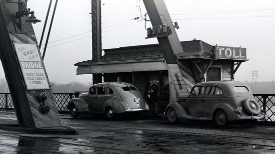
Library of Congress photo (1938)
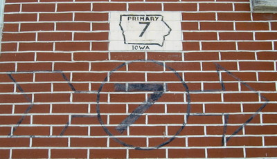
They wouldn't assign a significant portion of the River-to-River Road to a primary number if that number didn't go from river to river, would they?