
(July 1, 1920-October 16, 1926)
- In 1920, they knew it as: The Blue Grass Road, "a model dirt road through the famous Blue Grass Belt of Iowa," registered December 1, 1917, but born in October 1910 (12 counties)
- We know it as: L35 (old US 275) from Council Bluffs to Glenwood, and US 34 (pre-realignment/freeway) across the rest of Iowa
- The entire route with the exceptions of the Council Bluffs and Middletown-Burlington segments was paved in five years (1926-30). Significant portions, bypassed decades later, have their (often very patched) original surfaces today.
- Let's get granular: Huebinger's Map and Guide for Blue Grass Road, upon which much of the below is based, was field-checked in August 1911 (Chariton Leader) and published the following April. Below, BGR=Blue Grass Road.
- Council Bluffs: Broadway, Main Street, 9th Avenue, 3rd Street, 16th Avenue, High Street, Graham Avenue, Tostevin Street, South Avenue, Harry Langdon Boulevard
- Broadway assuming IA 8 was signed to the Missouri River
- Council Bluffs to Glenwood: L35 (before 2003, still US 275) from the Iowa School for the Deaf southward
- Glenwood: Not H30/old IA 949, but Sharp Street (turning at the Mills County Courthouse),Vine Street, Green Street (now broken at Keg Creek), Ives Avenue, a road paralleling H30/Ingrum Avenue to the southwest, Irish Avenue (dead end)
- Glenwood to Hastings: US 34, with abandoned segment Jurd
Avenue between former IA 242 and the
railroad
- Hastings to Corning: H34 (with unrounded corner at roadside park), Kane Avenue (east of Emerson south of railroad), H34, vacated G Avenue, Coolbaugh Avenue and (probably) Eastern Avenue in Red Oak, H34, T Avenue, 205th Street, H34
- Significant portions of H34, paved in 1928-29 and bypassed in the 1960s, retained their original concrete into the 21st century.
- Corning: 6th Street, IA 148, 4th Street, vacated road forming the west boundary of Happy Hollow Country Club, Kentucky Avenue, Hunter Trail and the extension of abandoned concrete to its east
- Corning to Creston: US 34, with the following stairsteps northeast of Kent: Beechwood Avenue, 220th Street (vacated to west), Clover Avenue, 205th Street
- I found no record of the primary going into downtown Creston. However, BGR followed New York Avenue then Adams, Elm, Clark, Birch, Fremont, Vine, Page, and Chestnut streets.
- Creston to Afton: US 34 with two left-behind segments named 180th Street
- Afton (1): Old Highway 34, Nuthatch Avenue with RRX abandoned in 1980s, 187th Street, Nebraska-Dodge-Railroad-Douglas streets (EB?)/Kansas-Browning streets (WB?), Kansas Street, Colfax Street, Filmore Street
- By 1924 (or earlier but it's not marked on the 1914 map), the Afton route changed from the BGR route listed here to avoid going south of the railroad.
- A 1920s traveler on Kansas Street would have seen the old Union County Courthouse in the town square.
- Afton (2): Old Highway 34, Jefferson Street, US 169, Iowa Street and vacated extension east, US 34
- In 1930, changed to a now-vacated extension of Jefferson and the present angled 34.
- Afton to Murray: US 169, 185th Street and vacated eastward extension north of Thayer, Kansas Street (part of which remains dirt today)
- Murray: 5th, Grant, 2nd, Colfax, and 1st streets, then R16
- Murray tried to fight relocation of the primary highway a mile south, saying it "will suffer untold and irreparable losses" (Osecola Sentinel, December 16, 1926) It lost, of course. The consolation spur became IA 152 basically at the same time the 1926 system was signed.
- Murray to Osceola: US 34, Old Highway 34 to Idaho Street, Ivy Street and vacated westward extension (broken at I-35)
- Osceola: Truman Road, Ridge Road, Cass Street, Jefferson Street, US 69/Main Street, US 34
- Osceola to Chariton: US 34, 315th Avenue, Sherman and Clarke streets in Woodburn, Idaho Street, 480th Lane, abandoned road on south side of railroad that runs into 487th Lane, 137th Trail, US 34, Front Street in Lucas, 185th Trail, 490th Street
- Chariton: Curtis Avenue, 16th Street, Brookdale Avenue, Auburn Avenue, Main Street, Court Avenue, Grand Street, Woodlawn Avenue, 7th Street, Albia Road, 472nd Lane (dead-end between Albia Road and Red Haw Lake State Park)
- Osceola Avenue is a "false positive", in a manner of speaking, at least according to the BGR guide. Maybe it's because this moved the RRX to the far northwest part of town rather than four blocks from the courthouse.
- Chariton to Albia: US 34; vacated stairsteps east of IA 68; old segments of 34 including 197th Trail, a tiny segment that is barely drivable, 204th Trail, and 196th Street
- Albia: Washington Avenue, Main Street, Benton Avenue, 192nd Place (corner)
- "It will not be necessary for the city to do any paving on West Washington in order to connect with the hard surface" because the state would do it, the Albia Union-Republican said October 31, 1927. The westernmost 1/3 mile, bypassed when US 34 was paved in the county in 1928, remains gravel to this day.
- Albia to Ottumwa: H35
- Ottumwa: Albia Road, Ferry Street, Richmond Avenue, Church Street, 2nd Street, Green Street, Main Street (dead end)
- Old East Main Street is blocked off at 110th Avenue; east of there, the original concrete remains.
- Old Agency Road is really old, as in old enough to be replaced by a more favorable route to the north by the early 20th century.
- Agency area: 73rd, 74th, Burlington, Ann, and Main streets; old (pre-2005) US 34 to near IA 16; US 34
- Miller Road, including an abandoned piece now used as a driveway, came with paving in 1926.
- Construction of the US 34 freeway broke or totally obscured parts of both previous alignments between the east side of Ottumwa and Agency.
- Batavia: Davis, 3rd, and Front streets, with dead-end old 34 east of the exit
- The portion of 1st Street north of Davis Street was part of the route from 1926, when it was paved, to 1955, when the entire route from the county line to Fairfield was repaved. Old pavement terminates by the diesel pumps at the gas station.
- Batavia to west of Lockridge: US 34 with a more-jagged route 2 miles east of Batavia, old US 34, Business US 34/Burlington Avenue, US 34 with the exception of 213th Street (double-dead-end), 215th Avenue and vacated eastward extension to county line, Velvetleaf Avenue, 218th Boulevard
- 213th Street, now serving three farmsteads, is at the extinct map dot of Glendale.
- The 1955 construction project also lengthened the curve between Fir and Filbert avenues; only a portion of the abandoned road remains (but follow the tree line).
- The Federal Aid Project No. 3 designation would remain in use through US 34's relocation in the Lockridge area in 1957.
- Old 34, aka 218th Boulevard, is blocked at Velvetleaf Avenue after four-laning cut off its intersection at the west end.
- Near Lockridge to Mount Pleasant: 218th Boulevard, 217th Street and vacated extension southeast, Old Highway 34, vacated extension southeast to bend in 225th Street, 225th Street, 4th Street and straight-south extension in Rome, Skunk River bridge just north of present 34, abandoned curvy route that can still be seen from the air, Dakota Avenue starting about where it turns northeast, Old Highway 34
- "Oak Tree in Road," the BGR guide said about 217th Street at the county line.
- A 1936 overpass at the CB&Q was removed in 2003, so now old 34 from the east flows into Benton Avenue. Ironically, this new part overlaps the pre-1928 route that then angled into 225th Street. You can tell where old meets new because the 1928 pavement exists to the west.
- A short abandoned scrap of 1928 pavement is just east of the intersection of Old Highway 34 and Dakota Avenue.
- Mount Pleasant: Courtland Street; Carnahan Road; Saunders, Elizabeth, Henry, McCoy, and Monroe streets
- I cannot pinpoint the exact time of the switch to Washington Street through Mount Pleasant. The route that connects to Goodyear Road to reach Old Highway 34 was paved in 1928. The diagonal to New London became part of the BGR in 1912 or 1913. The most likely scenario is that in the 1920s, IA 8 used Monroe west of downtown and Washington east, with one block of Jefferson Street (IA 40) connecting the two.
- Mount Pleasant to New London: Business US 34, US 34 (eastbound lanes), 260th Street and vacated extension northwest past Oakberry Avenue
- New London: Main, Elm, and Cleveland streets, plus vacated extension directly southeast
- Abandoned pieces of old 34 and old old 34 form a loop east of where the street now turns south to meet the four-lane.
- US 34 went to an all-Main-Street alignment in 1952.
- Des Moines/Lee county line to Middletown: Diagonal road on the other side of the railroad tracks, Columbia Street, Boundary Avenue
- The only trace left of this road outside Middletown is Plank Road in Danville. Paving in 1928 flipped it and eliminated the two RRX's at either end.
- Middletown to state line: Old Highway 34, Mount Pleasant Street, Chalfant Street, Lucas Avenue, Central Avenue, Washington Street, Main Street, High Street, MacArthur Bridge
- The road from Middletown to where it meets the four-lane remained part of US 34 until 2005. This segment contains the first rural four-lane divided highway built in the state. It appears to have been built in two segments: Middletown to former IA 80/IA 406 in 1942, and there east to Burlington in 1948.
- Related and sort-of-related routes:
- IA 41, Malvern's consolation prize for being taken off the BGR
- IA 97, Russell's consolation prize for being taken off the BGR
- IA 68, Melrose's consolation prize for being taken off the BGR
- IA 120, spur to Stanton, which was on the BGR but went 4 years without a state highway
- IA 129, later renumbered IA 123 (II), spur to Rome. The number was assigned in 1924, which is odd/interesting because from what I can tell, the highway route in the area did not change until paving in 1927.
- IA 152 (I), spur to Murray and part of the BGR. The segment in Murray was later secret IA 929.
- IA 213, spur to Blakesburg, which was on the BGR but went 10 years without a state highway
- Unsigned designations for bypassed segments (non-900's are four-lane-related):
- IA 231 (II): Old 34 through New London
- IA 334 (II): Old 34 between Agency and IA 16
- IA 340 (II): Old 34 in Batavia (another part of old 34 here was IA 981)
- IA 434: Old 34 from Danville to West Burlington, including part of the diagonal from 1928 and the original four-lane to Middletown
- IA 904: Burlington Avenue through Jefferson
- IA 934 (IV): Frontage road at Russell Sale Barn (unlike the rest in this segment, 34 is two lanes here)
- IA 935: Part of Mount Pleasant Street in West Burlington
- IA 949: Old 34 through Glenwood
- IA 951 (I): Old 34 west of the Clarke County Fairgrounds
- IA 980: Albia Road on the west side of Ottumwa
- IA 989: Old 34 between Albia and Ottumwa
- IA 983 (II): Old 34 outside Chariton city limits; also carried the IA 995 and 996 designations
WEST End (probable): Missouri
River (Ak-Sar-Ben Bridge), Council Bluffs
IA/Omaha NE, Pottawattamie County IA/Douglas County NE
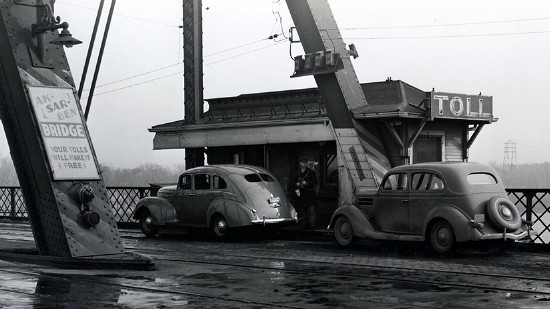
Library of Congress photo (1938)
It's much more likely that IA 8 was continued to Omaha, rather than end in downtown Council Bluffs, because the BGR continued into Omaha. The end of the auto trail was the New Henshaw Hotel at 15th and Farnam streets. The Douglas County Courthouse and Omaha City Hall are at 18th and Farnam streets, which the the nexus for routes in Omaha. This was the starting point of the Omaha-Denver Transcontinental Route ("An intensified highway from the Missouri River to the foot hills of the Rocky Mountains"), which ended at the Colorado State Capitol. That route was later incorporated into the Detroit-Lincoln-Denver Highway, became US 38 in Nebraska, and today is part of US 6.
WEST End (possible): IA 2/IA 6/IA 7, now Main St. at Broadway, Council Bluffs, Pottawattamie County
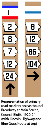
Facing north on Main (6/20/17)
It
might be the Harding - Federal Highway No. 34 may be great military
road running from coast to coast.
Senator Du Pont of Delaware, has introduced in the
present session of congress a bill providing for a super government
highway from the Atlantic to the Pacific. The proposed highway as
suggested by the Du Pont bill is to be 500 feet wide and to traverse the
most direct route and through cities of 2,500 only where impractical to
go round them. The bill provides also building tourist parks, emergency
airplane landing fields and emergency facilities and structure for all
navigation.
In view of the fact that the Harding Highway is
recognized as the most direct route across the central portion of the
continent we are wondering if it might not be the superhighway route
that the Delaware Senator has in mind.
It is hardly probable that our government is ready to
build the proposed super highway but it is only a matter of years till
the United States as part of her national defense plan will have at
least one great hard-surfaced government highway across the continent
from east to west and another from Canada to the gulf, and it is not
beyond the possibility that these two highways may be the Harding and
the Jefferson.
— Osceola Sentinel, December
16, 1926
EAST End: Mississippi River (MacArthur Bridge), Burlington IA/Gulfport IL, Des Moines County IA/Henderson County IL
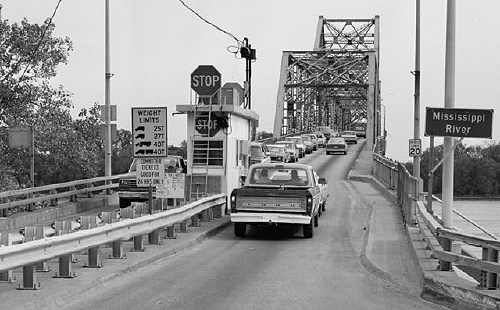
Facing east on 34 (October 1987)
Library of Congress photo
Page created 6/3/20