
The Iowa DOT’s draft five-year plan released this month still puts the big money toward urban interstate projects, but it has a couple of surprises inside.
One of the projects of note is IA 58 and Viking Road in Cedar Falls, labeled as a future interchange in the press release. I know the area, and have one huge question: How do you cram an interchange in there?
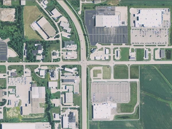
Here’s what the intersection looks like today (via ortho.gis.iastate.edu). The Target in the southeast quadrant was the last to fill in the area. Everything except half the buildings in the southwest quadrant, and the one building on the west side of the frontage road in the northwest quadrant, is less than 15 years old. The trail running along the east side is relatively new too.
Right now, there’s only one entry in the construction plan: Grade and pave in 2016, $16 million. No right of way acquisition, no “bridge new” — two things that usually come before or at the same time if an interchange is being built. The listing does say “State share,” so it’s possible that the city of Cedar Falls is handling those aspects.
Compare that area with the future interchange of US 218 and C50 (PDF) to the north in Janesville, which is comparatively sparse development-wise, yet will move the entire expressway over to the east.
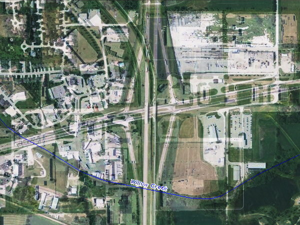
Here’s an overlay of aerial photos of the 58/Viking intersection with the interchange of I-35 and IA 122 at the same scale. While US 18/IA 122 is not directly east-west, and 58 curves, the interchange is about in the same spot; the ramps run the entire 450-pixel height and then some. Now, I know it’s not the easiest to see, but the interchange and right-of-way run:
- Right alongside the edge of Target and into its parking lot in the southeast quadrant.
- Through the western edge of the Farm and Fleet building in the northeast quadrant, plus a third of its parking lot — note that 58 curves, so the building might be spared but the lot wouldn’t.
- On top of the restaurant in the very corner of the northeast quadrant. It’s sitting between the mainline and the ramp.
- On top of the gas station in the northwest quadrant. With the curve, more buildings are in the way.
- On top of or near three buildings in the southwest quadrant.
There have been issues about traffic and accidents at this intersection practically since it was built (see, for example, here and here), so redesigning the area is not necessarily a surprise. Unfortunately, the road was built in the early 1990s on plans that had bounced around for decades, and ROW for a future interchange simply was not in the works. With the Avenue of the Saints, the intersection has become a victim of its own success.
It will be very interesting to see how this plan progresses.