
“My father had a farm in eastern Dallas County…” — “Progress,” Robert John Ford (from the musical “Utopia”)
The sight last week was so incongruous I couldn’t pass it up. Three bins, one tractor, one cornfield, just like so many other places in the state — except for the background. The harvest scene was surrounded by suburban multi-family units and buildings for the fastest-growing school district in Iowa. In the past the land was along what used to be a gravel 300th Street in rural Dallas County. Now it’s beside the four-lane-with-turn-lane concrete of University Avenue inside the Waukee city limits.
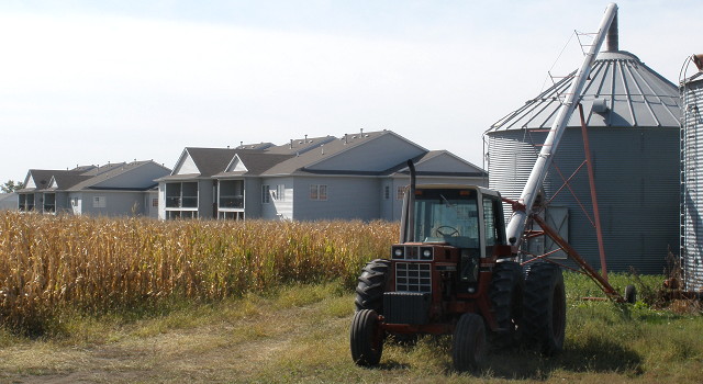 Cornfield in Waukee, across from Prairieview Middle School
I don’t know who owns or farms the land; it’s unlabeled on this map of property owners in the area (PDF). I don’t know if the owner has been offered money, and if so how much. Farmland in Dallas County is worth more than $7,500 an acre, but here in the middle of it all that would be an ultra-lowball offer. Its time as farmland, though, is certain to be short.

via ortho.gis.iastate.edu
That’s the way this whole area looked from the air March 12, 1990. See the bins? They’re along the road, in the upper-left corner of the dark field. The entire view is farmland, one road, and the old Chicago and Northwestern Railroad. In 2005, the now-Union Pacific line was terminated in the vicinity of this photograph, and the tracks were removed from the state map, from Waukee diagonally northwest to Perry and then Dawson.
This is what the same area looked like last year:

via ortho.gis.iastate.edu
The three bins are still there, dwarfed by the oddly-shaped buildings across the street (Waukee High School and Prairieview Middle School). The north-south road coming in from the top and ending at University is Alice’s Road. Waukee and West Des Moines have received grants to extend that road down to I-80 and have a new interchange there. The bridge has already been built.
In the immediate future, Alice’s Road is going to be extended down to I-80, first as three lanes, then six. Planners expect it “to carry over 20,000 trips per day.” Every square inch of the area that hasn’t already been developed has been hammered into a structured “master plan” that stops just short of saying where individual trees will go. It has already been decided that this cornfield will be commercially zoned, with “Office Class B” space where the bins are, and some “Retail Community” to the east.
In other words, they’ll pave paradise and put up a parking lot.

All throughout this area, some of the richest soil in the world has seen the plow for the last time. But in this harvest season, the three bins still stand there, the last icons of the land’s pastoral past, waiting for the inevitable destruction of progress.
Sources:
“Iowa Farmland Values-Iowa Workforce Development” (Excel spreadsheet)
“Alice’s Road Corridor Master Plan”, p. 2, 7, 8 (8 MB PDF via link)