
Short of the Supreme Court declaring the Senate unconstitutional (see: Reynolds v. Sims), there will be large population mismatches in Congress. Even with the House reapportioned as it is, Iowa’s per-district representation is higher than all but two multidistrict states.
Online mapmaker Neil Freeman has twice tried to “rectify” the situation.
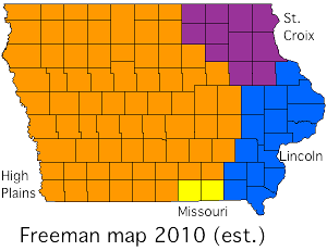
His first effort, in 2010, divided most of Iowa into three different states. (Note that Missouri really didn’t change much, showing that it’s very close to average in population, but did steal Appanoose and Davis counties.) I can’t tell for certain, but this is what I think his first mockup does. High Plains includes Nebraska, the Dakotas, and eastern Montana and Wyoming; St. Croix is the eastern two-thirds of Minnesota and western Wisconsin; Lincoln is much of downstate Illinois.
That version started with existing state boundaries. His new version, which has a much more detailed map, starts with metro areas. Iowa again gets divided mostly into three states. (Image also here.)
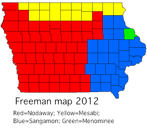
Des Moines is the capital of the new Nodaway, centered near Corning, which includes the Kansas City, Topeka, and Sioux Falls metro areas, plus eastern Nebraska. Sangamon (capital Springfield) is centered east of Keokuk and has eastern Iowa, western Illinois, and northeast Missouri including St. Louis, Columbia, and Jefferson City. Mesabi (capital St. Paul) is reconstituted Minnesota, far western Wisconsin, far northern Iowa, and the I-29 corridor north of Sioux Falls. Dubuque County becomes a corner of Menominee (capital Madison), which is most of the rest of Wisconsin excluding Milwaukee, Michigan’s Upper Peninsula, and the west half of the Lower Peninsula.
Note on the map, again, how empty the West is. Four states are all that are needed for the Rockies and much of the Great Plains. Chicago is a city-state unto itself.
In the redrawn country, while the Gladbrook-Reinbeck school district now finds itself in two separate states, Iowa State gets to play Nebraska and Kansas (and UNI) as in-state rivals while Iowa and Missouri can fight the Honey War. Of course, now the problem is that all of them have to change their names — and the state of Nodaway has two counties named Cass.
Freeman admits this is an art project/academic exercise, but it’s interesting to see how borders would have to change to be equal in population (at least until the next census).