
After 3½ years, Missouri finally updated its state highway map. The previous one was labeled “2010-12” and this one was released just two months ago.
The biggest, most visible change is the addition of I-49 along US 71 on the western side of the state, down to Pineville. (Less notably, the interstate/business loop markers are now a lovely shade of barf, at least onscreen.) But then, when you look at the St. Louis area, you see a new interstate drawn in.
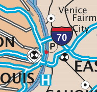
Attached to that I-70 marker is the Stan Musial Veterans Memorial Bridge, which has been under construction and kind of under the radar for the past five years or so. As the Midwestern interstate system goes, it’s one of the biggest changes to an existing interstate in the past quarter-century. Other changes have been extensions (I-64, I-355) or new designations (I-49, I-88, I-39).
However, the bridge won’t open until next spring at the earliest. This is MoDOT’s attempt to future-proof the map, which says “Centennial Edition” but does not include a year or span of years. The St. Louis inset includes the new bridge, too, and has I-44 taking over that part of I-70 past the Gateway Arch, but with the existing exit numbers still attached.
Construction of the new bridge and surrounding interstate is being affected by, of all things, the St. Louis Cardinals in the World Series. In the fall 2013 newsletter (PDF), an Illinois DOT official said in regards to work on I-64, “If the Cardinals continue to be successful through the post-season, we are considering completing this project during non-peak traffic hours with lane closures.”
A close study of the construction plans reveals that the interchanges at either end will not be complete interchanges. Certain traffic movements won’t be included. When new I-70 opens, work on the existing Poplar Street bridge and the I-55/64/70 interchange will eliminate some traffic movements there too, notably former eastbound I-70/new westbound I-44/southbound traffic onto the PSB.
Elsewhere on the map, the overextended I-155 has been brought back to its actual length and endpoint in Tennessee, but there’s an I-670 shield sitting on US 71 between I-435 and I-70. Go figure.