
Toledo, Ohio, Oct. 4 — I drove in downtown Detroit, and around Detroit, and survived, clinching the entire portion of I-94 east of the Missouri River* along the way.
Route: I-280, I-75, M-39, I-94, I-75, I-375, (loop Woodward to Michigan-Cass and downtown), M-10, I-75, I-94, BL 94, I-94, I-696, I-275, I-75 to x199 and turn around, I-475, I-75, US 20, OH 420, I-280
I-75 was six lanes all the way, some parts in better condition than others, and early rain cleared up halfway between Toledo and Detroit. I hopped off the interstate only to cut to I-94 and take that to close to downtown, then looped into downtown. Cadillac Square at noon was bustling, but I made it through. I-375 ends as the freeway turns southwestward into a boulevard, only for the boulevard to re-emerge as a freeway heading northwest. There was no Spur I-375 signage.

Michigan attempted to conserve space on this sign by putting two cities on one line, but there needs to be a hyphen in there or something. This is on M-39.

Graphical BGS leaving downtown Detroit.
The drive to Port Huron was nice, mostly four lanes. Construction at the west I-69 interchange and AM radio said to tune to AM 1610 for info. A looping message said GPS users might not know that last exit before Canada is now a right turn. This matches new Google Maps. Indeed, there are national flags on the last BGSs before the Blue Water Bridge. Where before a fork to M-25 was the last US exit, now the last exit is much earlier on I-69/94. However, the on-ramp remains still a short distance north of the freeway, so the business loops still double back.
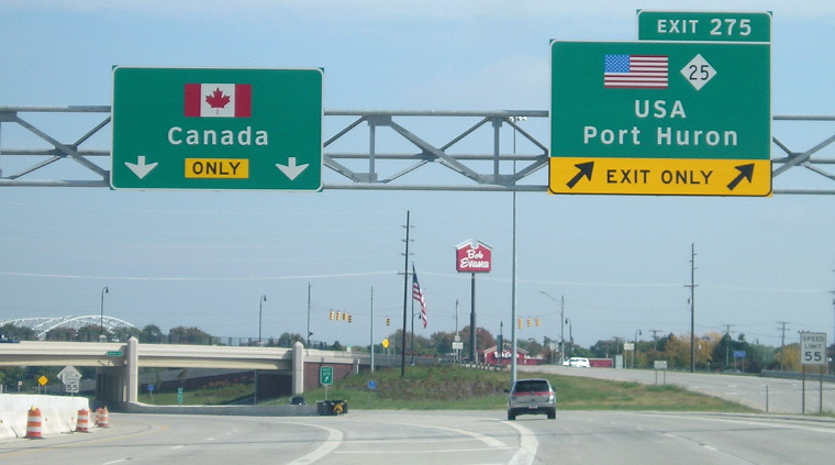 If you keep left, you will have no choice but to enter the land of poutine.
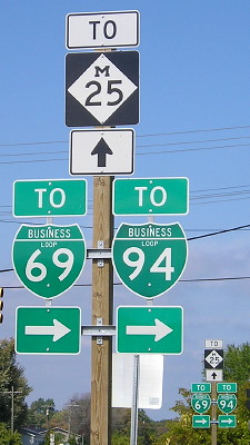
Interestingly, this sign set at the intersection of the offramp from WB 69/94 (the first US exit) and Hancock Street in Port Huron directs “TO” the business loops, not the business loops themselves. However, the intersection of Hancock and Pine Grove (M-25), just to the east, signs BL 69/94 as if they turned onto Hancock and then turned again here to rejoin the interstate.
I came back down on BL 94 and took the interstate back to 11 Mile Road, where I-696 started. I-696 and I-275 form the “loop” around Detroit, and arguably the complex interchange at their meeting has I-696 go a bit west to end, but I followed the westbound-to-southbound mainline. I-696, despite its large amount of lanes, was moving quite rapidly.
After I crossed the state line, button copy and sound walls returned. I went halfway to I-80 in order to close my I-75 gap in Toledo. There was some construction going on at the north 75/475 interchange, and it needed it; 75 was a pretty rough road.
Here, at the north beginning of I-280 from I-75, Ohio uses the word “Turnpike” instead of the Ohio Turnpike logo or I-80/90 shields.
Then I-475 co-signs with US 23 (which itself could be an interstate all the way to Ann Arbor), and both the pavement and the signage get markedly newer going south.
New counties so far: 39 (2 IL, 10 IN, 11 KY, 2 MI, 13 OH, 1 PA)
*If I had done this on the heels of my first Canada trip in May 2007, I could have said “I-94 in the Central Time Zone,” but Morton County has shifted completely over from Mountain to Central, making North Dakota’s time zone map weirder in the process.