
This corner is all that’s left of Bloomfield Township in Polk County (2013 map).
Polk County’s Bloomfield Township has been gradually shrinking since it was created.
In 1875, the township had boundaries of the Raccoon River, the section line that is now along Hartford Avenue, the Des Moines River, and the section line corresponding to East 30th Street. It ran 12 miles across the bottom of the county.
Sometime between that year and 1912, possibly in 1890 when the city of Des Moines greatly expanded, townships in the southern half of Polk County were completely redrawn. The city of Des Moines was now in Des Moines and Lee Townships, which together formed a rectangle that at the time encompassed the city. Bloomfield Township was squished down, its northern extent now Watrous Avenue except for a small part west of 63rd Street.
In 1957, Des Moines moved its city limits southward, but only between Southeast 14th Street (US 65/69) and the airport, splitting Bloomfield Township in two. West Des Moines, however, still maintained the Raccoon River as its southern boundary. That remained the case (save the addition of Ewing Park in 1975) until 1989 — just in time for the 1990s redistricting — when Des Moines went west to 63rd Street and east to East 36th Street, closing the eastern Bloomfield portion. Six years later, West Des Moines, feeding a new addiction to land, finally jumped the Raccoon, eating into Bloomfield between 63rd and what by that city’s grid is 11th Street.
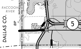
Finally, in 2002, as the IA 5 bypass was being completed, West Des Moines made its last annexation so far in Polk County, taking everything east of I-35. Two other small moves also occurred in the 2000s: Des Moines’ involuntary annexation of Fort Des Moines Park and Norwalk’s annexation of the tiny strip south of IA 5 around the IA 28 exit. That left a very rump portion of Bloomfield Township.
Today West Des Moines owns much of the southeast corner of Dallas County (PDF), except for the portion south of the Raccoon River in the easternmost two miles. The excluded portion includes the already existing development west of Dale Maffitt Reservoir.
Why didn’t West Des Moines finish off the job and end Bloomfield Township’s existence? The answer requires a look beyond the map to aerial photos. The area left as a rural part of Polk County mostly consists of one municipal facility — the Des Moines Water Works. It’s why Maffitt Lake exists.
So West Des Moines has to leave the land un-annexed. Otherwise we’d have a situation where one city’s water treatment facility is on land that’s part of another city — geographically quirky, but politically troublesome.