
Now that the Republican primary for the U.S. House Third District has been held, it’s time for a look back at a well-traveled representative. Tom Latham moved from Alexander to Ames to Clive while representing 57 of Iowa’s counties at one time or another over 20 years.
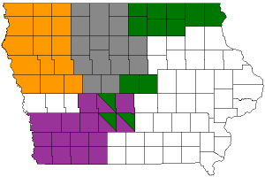
The orange and gray represent the Fifth District of the 1990s, the green and gray represent the Fourth District of the 2000s, and the purple is the Third District of the 2010s. (This color scheme and map are based on my Iowa Congressional Maps series. Right now the bottom is about the delegation members through 2007, and I haven’t decided how I’ll update that.)