
Next spring, Iowa will publish its first two-year map under a cost-cutting measure. There won’t be another one until 2017.
Along with the new US 34 bridge, there are at least three other areas that need modification.
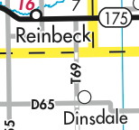
- Tama County blacktopped T69 north of D65 to the Grundy County line. (I don’t have any external links or a picture, though.)
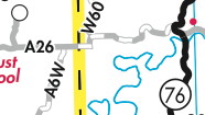
- Allamakee County paved A26 from IA 76 to the Winneshiek County line. (Supervisors minutes)
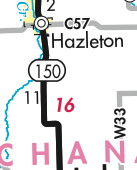
- The sharp curves in IA 150 south of Hazleton are are now a gradual slant.