
A combination of having politics and state borders on the mind…
The Connecticut River forms the border between Vermont and New Hampshire, two states that would fit comfortably inside Iowa. Halls Creek forms the western part of the border between New Hampshire and Quebec. But Halls Creek flows into the Connecticut just south of the 45th parallel (Quebec’s border with Vermont and Upstate New York, at least ideally) while the Connecticut River takes a tack east.
That means at the town of Beecher Falls, Vermont, the Green Mountain State’s northern border intrudes less than 2 miles into the Granite State.
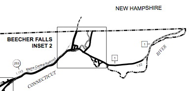
That’s from the Vermont Agency of Transportation’s map of the “Town of Canaan” in Essex County. Boundaries in New England far predate township-and-range, of course, and looking at a map of Vermont’s “towns” makes you appreciate that system that much more.
Here’s a link to the spot on Google Maps (at least, I hope it’s a link). US 3 runs on the New Hampshire side.
The New Hampshire primary is today, and there’s one burning (Bern-ing?) question: Will Vermin Supreme get more votes than Jim Gilmore?
UPDATE: Yes he did! (241-125 after midnight CST)