
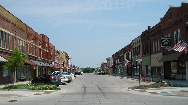
July 7, 2013: Downtown Belle Plaine is a block south of today’s signed Lincoln Highway route. Main Street, formerly 12th Street, is now one-way eastbound.
It’s time to refine the history of the Lincoln Highway in Belle Plaine, and along with it the earliest history of one of Iowa’s most iconic transportation landmarks.
I have known for a long time that the alignment of the main road through Belle Plaine wasn’t always on 13th Street. I knew that George Preston’s gas station started in a location that is not the one we know and love today. What I didn’t know, and have discovered through research that five years ago would have been an eye-straining needle search through a microfilm haystack, is that the history of both is more complicated than I thought.
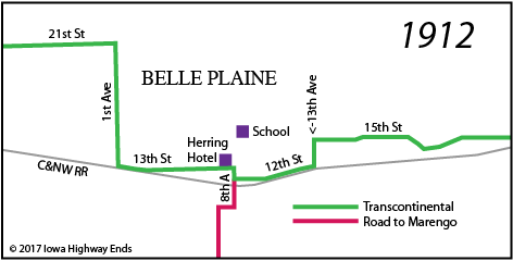
We start a year before the Lincoln Highway was created, in 1912, when the Iowa Publishing Company put out Huebinger’s Map & Guide for Iowa Official Transcontinental Route. That guide has been digitized at the University of Iowa Library.
This is not the route signed as a Lincoln Highway loop today. However, this is the route that would have been adopted in fall 1913 when the Lincoln Highway was announced to great fanfare. It was that way for at least the first year, because on July 9, 1914, the Belle Plaine Union reported that a road grader “will go onto the Lincoln Highway, beginning at 7th Avenue and 13th street and this road will be graded west to 1st Avenue and then north to the Edwards corner.” Then a year later, on June 3, 1915, the Union interviewed Lincoln Highway Association President Henry Joy on his famous trip along the Lincoln to San Francisco:
“Commenting on the routing of the Lincoln Highway in Belle Plaine north on 8th Avenue from 13th street to 19th street thence west to 7th avenue and north on 7th to 21st and thence west, Mr. Joy said it was just the thing and that he highly approved of the change, which gave the tourist a better route through the city and a better impression of the city.”
That’s the modern-day loop, running north from downtown and then leaving to the west. The first route followed the railroad more, but this one goes past the high school built in 1911. The intersection of 8th Avenue and 13th Street is the site of the Herring Hotel, which after falling into disrepair in the late 20th century is in the early stages of restoration.
But instead of turning east there on 13th to head toward Cedar Rapids, the Lincoln Highway went a block more south, then turned east through the business district, and had two corners and an angle before reaching Buckeye Clay Products on the edge of town (marked on Huebinger’s Transcontinental as “Brick Kilns” and today the site of Pierce Lumber). This difference is small enough it is not on state maps of the time, but you can see it driving there today, because the cemetery entrance is offset from the modern road!
Cities were in charge of improving all roads inside city limits, even this primary road, which received the IA 6 designation in 1920. Thus, it was up to Belle Plaine to do what at the time was known as the 12th Street extension because it followed the skew of the street closest to the railroad. That opened in October 1923.
While that was happening on the east side of Belle Plaine, on the north side, George W. Preston bought the gas station at the intersection of 7th Avenue and 19th Street. Thus, the Preston Station is “Since 1923”, and on the Lincoln Highway, but in the wrong place…and that’s where Part 2 will pick up.