
The USDA’s Plant Hardiness Zone map “is the standard by which gardeners and growers can determine which plants are most likely to thrive at a location,” the website explains. Three sub-zones — 4B, 5A, and 5B — cover Iowa except for a narrow band at the southernmost point.
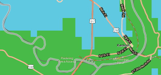
The blue is Zone 5B; the green is Zone 6A. At this rendering level, the 6A line creeps up the Mississippi River to Galland School but doesn’t extend beyond the shoreline. On land, the green zone runs a mile and a half to two miles into Iowa, including part but not all of Keokuk. The east part appears to run near the survey line between sections 22-23-24 and 27-26-25 in T65N. Since most of the Keokuk city grid is angled, there’s no numbered street running the length of the line, but the short Cleveland Avenue is there.
The entire run of US 136 in Iowa lies inside this growing zone. It’s still not a place to put palm trees, though.