
September 17, 2007: Westbound US 18 at US 75 in Sioux County. There are some ag-related businesses here, half a mile east of the unincorporated village of Perkins (which consists of a few houses and a salvage yard).
I have wondered if it would ever be possible to track down the status of US 18 in the fall of 1926, given the many documents that showed the highway was scheduled to end at US 75 but by every 1927 map had it already continuing into South Dakota.
As late as Oct. 4, 1926, the Iowa Highway Commission declined to join the South Dakota Highway Commission in requesting that US 18 be extended west to US 85. That was coming right up against the installation of the route markers in Iowa, which began about a week later and was completed Oct. 16 (as Jason Hancock learned a long time ago). This was on the early end of signing across the country, working off plans that had been two years in the works.
Now, thanks to a short front-page article in the Sioux County Index of Hull*, I have the best confirmation we’re likely to get that US 18 was SIGNED to end at US 75 for a brief period in late 1926. According to the story, the extension was approved at the AASHO meeting of November 11, 1926, which is considered to be the official birth of the federal highway system.
Black Hills Highway
O.H. Hetli, State Engineer, of South Dakota, was present at a government meeting of State Highway Engineers in Pinehurst, North Carolina, on Monday. In the interests of the Black Hills Hiway, Mr. Hetli asked that Federal Highway No. 18 be extended from Perkins Corner, west through Inwood over the Custer Battlefield Hiway, across South Dakota over the C.B.H. into Wyoming to the point where it intersects with U.S. No. 85, which then takes it into Denver.
— Sioux County Index, Nov. 26, 1926
US 18 would have been signed into South Dakota by the end of the year, since 1927 maps and the Highway Commission’s service bulletin all say so. To make a comparison that no one would have understood 90 years ago, Iowa’s October signage was based on a software “late beta” before the release of Version 1.0.
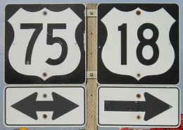
So, for a few short weeks at the end of 1926, the equivalent of the assembly shown here read “End 18.” After that was changed, for about three years, 18 and 75 went a mile north, then three miles west, heading north on K42 toward Doon. Then they split and 18 went west on A42 to Inwood and 75 angled northeast toward Rock Rapids.
Ironically, through all the early preparation and fine-tuning of the system on both the state and national levels, it appears no one ever looked at the maps and said, “Hey, wait a minute. US 218 is based on an even number and is going north-south. What’s up with that? Why isn’t it US 265?”