
We have a lot of census-related numbers floating around right now, and each makes one piece of a puzzle, but it will be hard to put them all together until the granular data comes out later this year. Here’s what I DO know:
- The OFFICIAL April 1, 2020 population of Iowa is 3,192,046. This is 30,000 greater than the July 1, 2020 estimate of 3,163,561. The estimate is “without incorporation or consideration of the 2020 Census results” but still, that’s a LOT.
- That’s 798,011.5 per congressional seat. Anyone got a house straddling county lines?
- That’s officially 31,920 per state House seat (larger than 77 individual counties) and 63,841 per Senate seat.
- The 2020 estimates amount to 790,890/31,636/63,271.
- That’s a difference of 7,121 per between estimates/actuals per district — more than the populations of 12 counties. (Three more are under 8,000.)
- The 2020 county estimates released May 4 will be superseded when intercensal numbers come out in 2022.
- The fear of Iowa losing a seat in 2030 is far-fetched. In 2010, when Iowa went from five representatives to four, it had the third-most people per district of states with more than one representative. One of the two with more, Oregon, is getting another seat for 2022. Iowa will have four people in the U.S. House in the 2030s.
All that said, I can still make maps based on the data that doesn’t count — for entertainment purposes only, of course. Maps with those numbers (the estimates that will be voided in 2022) will come later, but I’ve already found one wacky circumstance.
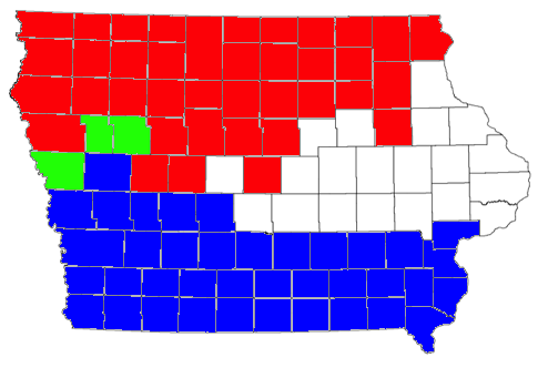
The BLUE counties plus Ida, Sac, and Monona = 790,150. The RED counties plus Ida, Sac, and Monona = 790,150. This number is 740 less than the per-district division from the 2020 estimates, thus a functional number for the second iteration of my redistricting game. If I assign Boone County to the Blue Group and the other three to the Red Group, both will form districts that vary from the 2020 estimate ideal by less than 1000 — and look like plausible districts, to boot. This also means that the remaining 19 counties account for half the state’s population.
Coming up with exactly 790,150 people through two almost completely different county combinations? That’s far out, man.