
Pinning down early highways in places that fall in the “large town” category is often difficult. Records are sparse and, because the state was not in charge of routes within city limits until later, county maps omit detail and city maps almost never exist. The two communities I’ve found hardest to decipher are Greenfield and Centerville. Both have two state highways that follow straight alignments today, but both also have a courthouse square that is off those routes, which is a solid indication that what we see today wasn’t always the case. I think I have been able to reverse-engineer Greenfield but Centerville has an additional complication: Its street grid is inconsistent.
Original routes on the edges of town came without too much difficulty. I knew that original IA 60 left to the south on Drake Avenue, and original IA 3 came in on Washington Street and out on State Street. But Drake stops at Maple (present IA 2), and the State-to-Washington connection eluded me.
Then, when the DOT put up a handful of “Early routes” files, what I thought to be a sure thing wasn’t quite so. Yes, Haynes Avenue today changes directions and it’s a dead giveaway to IA 60’s previous route, but it didn’t exist north of Franklin Street until 1924. Haynes and Drake are half a block offset from each other.
Through a lot of combing through the DOT archives and the Centerville Iowegian archives (typically in the manner of “let’s see if this particular phrase gives me anything”), here’s what I’ve been able to come up with for Centerville’s highways. Years in parentheses show realignments. To cover changes south of Centerville, I have a “gap” in the map.
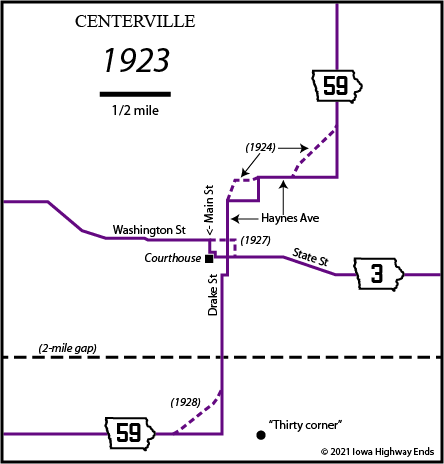
The courthouse area is derived from a small Iowegian item September 16, 1927, specifically mentioning that the route had “led onto the square” but will now use 15th Street.
While I’m on the topic of Centerville, I’ll bring up these bullet points:
- See this blog post for more about the north-south highway in Centerville, which has had four different numbers. Specifically, it’s about the curve labeled “(1928)” above.
- The newer building of the Motel 60 complex was renamed Westbridge Inn and Suites in 2017. I do not know if the original part remains active.
- The Double R Dairy Bar, a longstanding local eatery at the northeast corner of the IA 2/IA 5 intersection, closed in 2017.
- Google Street View has yet to go through anything in town other than the highways and right around the courthouse. Can they get on that and similar situations rather than adding to their eight sets of I-80, please?