
The actual 2020 census numbers came out yesterday, in extremely large and complex files meant to be interpreted by extremely expensive and complex software. I am but a simply country blogger of limited means. So, in order to get fast numbers, I had to take the brute force approach: Stumble upon this interactive map, go to Iowa, select county-level data, and manually enter 100 lines.
Behold, Mock 13, on Friday the 13th, which like my first mock redistricting presents Ashley Hinson with her worst nightmare: Johnson County. (I did some other maps in the interim. Mock 12 was a self-check of this proposal at Bleeding Heartland, which appears to have used 2018[?] estimates and substantially undercounted Dallas County.)
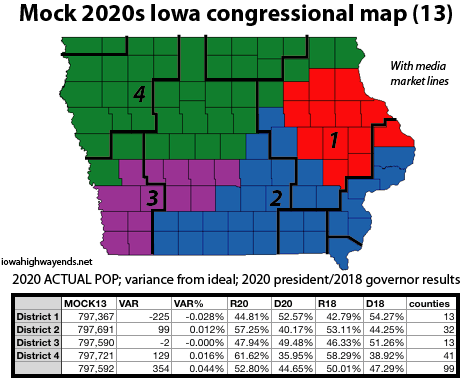
LOOK AT THAT THIRD DISTRICT. IT’S SO PRETTY. Number-wise, I mean, and map-wise, kinda too. But remember when I said that working on Polk County-centric districts often led to a busted map because east-central Iowa kept throwing things off? A similar thing happened here. I played with different reconfigurations of the counties on/north of I-80 — only to realize, in separate maps, I’d forgotten to include Lee and Wayne counties — and landed on this when I said good enough. There’s a variation that swaps out the northern ones for Johnson, and it fits within my self-imposed 1000-person deviation, but it’s not as close to the ideal.
Looking at the partisan breakdowns, I don’t know if the Legislature would bite on this one. Any map that puts Johnson and Linn together could meet resistance … unless the state legislators are very happy with how their districts turn out.
UPDATE: Better map placed shortly after post time.
UPDATE 9/22: Fixed slight Scott County population error.