Corrections are important, even if they come 110 years late. This one affects stuff I’ve written recently.
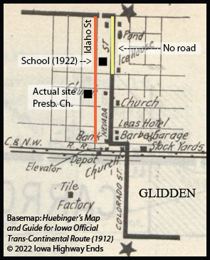
Huebinger’s Map and Guide for Iowa Official Trans-Continental Route, published in 1912, draws Glidden’s business district in the wrong place.

Huebinger puts the business district at the south end of Nevada Street, with a full extension to the north side of town, where US 30 is today. However, a 1906 county atlas and modern Google Street View show that neither are true.
The “bank” building marked in the map exists today, at the corner of Idaho and 1st streets. The Presbyterian Church is also a block west of where it’s marked. The school, built in 1921-22, did not need to take out a part of Nevada Street because that part of Nevada Street never existed. It’s marked as an “irregular survey” in the 1906 city map.
There are at least two cases where the route appears to have shifted between the time the guide was created and the time the Lincoln Highway took the route as its own, but this is the only outright, unexplainable map error that I’ve found.
So in Huebinger’s route, the Transcontinental should have gone down Idaho Street, then used two blocks of 1st Street before going south on Colorado Street. From what I can tell, Idaho continued southward to the next road at the time, instead of the Transcontinental needing to use Colorado, and the 2011 Heritage Byway reflects that.
Idaho Street’s time as part of the Lincoln Highway was limited. Two railroad crossings between Glidden and Ralston could be eliminated if an alternate route a mile north became official. The day before the Lincoln was dedicated, the Glidden Graphic newspaper warned against a change in the route. In early 1914, as Iowa State Highway Commission county maps were being finalized, the south route to Ralston was omitted completely. “We Lose the Highway,” the Graphic editorial headline said Feb. 12, acknowledging defeat but vowing to continue support for the road.
Gregory Franzwa wrote in his 1995 book on the highway in Iowa, “Strangely, old-timers insist that, this evidence notwithstanding, the Lincoln Highway did in fact come in from the south and pass through the business district.” He found correspondence in the national association’s archives showing multiple officials had the wrong impression about the road.
Either way, the south route is remembered today with the Heritage Byway Loop that goes through Glidden, east on 210th Street, and past the corner markers that George Gregory set up in March 1914. IA 6 and US 30 always skipped downtown Glidden.
