
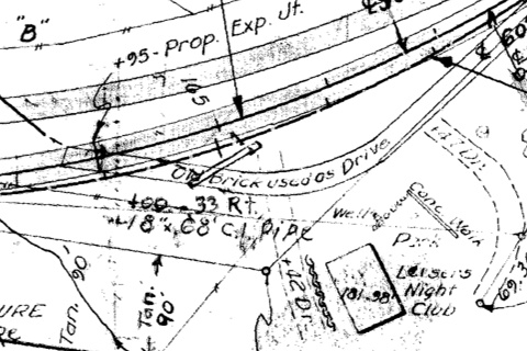
This clip from 1949 Iowa Highway Commission blueprints shows three alignments of IA 3 in Sageville that are nearly on top of each other. The top gray line is the 1932-49 pavement. The middle, with a centerline, is a change to the curve. “Old brick used as drive” refers to the original brick road that ended a few hundred feet away. The building for Leiser’s Night Club remains.
Federal Aid Project No. 148 in 1927 paved today’s IA 3 in Dubuque County between Luxemburg and Boy Scout Road or “Gillespie Hill”, with an official stop at the Little Maquoketa River. However, the route through Durango, one of the trickiest winding roads in the state, remained gravel. (In a 2002-06 traffic study, 42% of crashes were animal-related, mostly deer.) For unknown reasons, state maps mark the segment west of Sageville as paved years before it actually happened.
An ad in the Cascade Pioneer on May 23, 1929, explained that the $1.8 million bond issue had covered previous paving, and $900,000 more was needed to pave north of Luxemburg, Durango to Sageville, and Key West (the US 61/161 junction just south of Dubuque) to Cascade. The road through Cascade had been paved with Jones County’s portion of US 161. The bond vote four days later passed in Dubuque County by a 5-to-1 margin, a huge swing from 7½ years earlier, when the bond could only muster 10.7% of the county outside the city. In fairness to the farmers, the November 1921 bond vote fell under a different regime that charged landowners who lived within a certain distance of a paved road a special assessment. But that also meant that voting down bonds meant being, well, sticks in the mud.
Dubuque County’s $2.7 million in primary road bonds would end up being the sixth-highest in the state.
This bond approval happened early enough in 1929 that half of the US 161 project, from the east city limits of Cascade to about a mile southwest of present-day D41, was completed before winter. The rest was finished in 1930, along with US 55 north of Luxemburg. The road through Durango, however, needed a two-step process that would also override one of the oldest paving segments on the Iowa map.
In 1930, US 55 was realigned from Durango eastward to avoid two crossings of the Chicago Great Western Railroad. The old route is Burtons Furnace Road today, but half of it was vacated in the 2010s. The west end of the 1932 paving plan was at Boy Scout Road/Little Maquoketa bridge, but the east went all the way to the Dubuque’s then-city limits, on the section line, now approximately the intersection with Ruby Street.
The “monolithic brick” road from the Dubuque city limits to Sageville was one of Iowa’s first hard-surfaced segments outside of city limits. It was approximately 3⅔ miles long and built in 1917-18, as covered in the Iowa State Highway Commission Service Bulletin. But in 1932, likely due to a combination of improved road-building techniques and 15 years of wear, a concrete surface was called for.
Parts of the brick roadbed were overlaid, but other parts, including the area at the CGW overpass, were bypassed, and no trace remains today. The CGW trackage was abandoned in 1981 and is now the Heritage Trail. The 1932 roadbed south of the C9Y intersection was partially bypassed in 1974; what’s left is Sageville Road and a short stub named Welcome Way. (This means there are three semi-distinct alignments of the highway between the former IA 386 junctions, but only 1½ remain.) The brick ended at the C9Y junction, but the curve between there and Leiser Lane was more angled. Some remnants of the 1932 route and Leiser Lane angle no longer exist in the field, but do exist on the map: The city limits of the southern extension of Sageville incorporate both.