
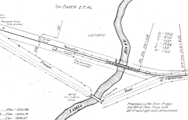
This 1918 construction document for “Inter County Highway” shows the plan for a truss bridge south of Leon. Note the intricate illustration for the river.
The 2023 Jefferson Highway conference starts today in Mason City.
The Jefferson Highway, also known as the “Pine to Palm Highway”, ran from Winnipeg to New Orleans. In Iowa, this became IA 1 in 1920. Today, for the most part, it follows the US 69 corridor south of Ames and the US 65 corridor north of Colo, overlapping the Lincoln Highway in between. A few years ago, it was signed as a Heritage Byway in a manner identical to that of the Lincoln Highway, complete with loops for old alignments. The most notable loop is Ankeny to Nevada via Elkhart and Shipley. Here’s the Iowa DOT online map. Here’s a complete Winnipeg-to-New-Orleans map with points of interest.
Unfortunately, signage of the route leaves a lot to be desired. It completely disappears between Indianola and the intersection of University Avenue and East 13th Street just north of I-235. For now, I’m going to leave Des Moines and other locations aside and pick out/pick on two big issues in Decatur County.
May 20, 2023
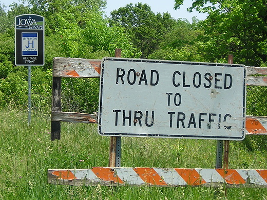
The Jefferson is signed very cleanly onto “Old 69 Highway” between Davis City and Leon. The problem is, it heads right to a bridge that has been closed since the end of 2016, according to supervisors minutes. A certain unsuspecting traveler found this out the hard way, but at least 255th Street was there to avoid a full backtrack. The present county map marks old 69 as a continuous road.
Northbound only, there is signage for a loop following 250th Avenue and Popcorn Road. This is the route used before 1924. Much of 250th here is graded dirt and likely would have been considered decent for someone driving west of the Mississippi River in the 1910s, as long as it hadn’t rained much in the past 48 hours. Getting a steady 25 mph was an achievement back then. However, the turn onto Popcorn isn’t signed, the return to US 69 isn’t signed, and there is no signage on 69 at Popcorn indicating the loop. A mile north, at the east end of former IA 258, there’s a double-arrow for J14’s intersection with the Jefferson.
The 1921 Blue Book for the Upper Midwest, Vol. 10, covers major routes for Iowa north of and including the Lincoln Highway, with a special extension of the Jefferson Highway south to Kansas City. In Leon, this routelog uses 7th Street instead of 10th Street to go over a block from Main Street to present US 69. This illustrates a difficulty with trying to retrace auto trails: In-city routes were at times closer to suggestions than hard-and-fast designations. They could change when a certain street was paved or on the whim of a city council.
In the 21st century, though, good signage is imperative.