
For years I have tried to reconcile early 20th century maps of the area just east of Traer with the present alignment of IA 8. I knew that at least part of the diagonal heading east from Second Street did not exist until 1940. I thought I had a solution with a bridge connecting Second Street at the edge of Traer to the Chicago & North Western railroad depot, but that bridge was washed out in a flood in 1924, so at least part of the time the route had to be somewhere else.
It turns out that I was trying too hard.
Commission favors change in No. 58
The state highway commission has notified the county board of supervisors that it approves the change in the route of primary road No. 58 into Traer on the east, by which it is proposed to make about a half mile of new road from the Axon corner, east of town, through the Sieh farm, entering Traer on Second street instead of First street [emphasis added], passing the south side of the C.&N.W. station. This would eliminate two corners. The change to be effective must yet have the approval of the county board.
— Traer Star-Clipper, November 11, 1923
Second Street west of Main Street/US 63 is Traer’s business district, but there are some businesses to the east. That street connected most directly with the railroad depot, but dead-ended after the bridge. That’s where I kept running into problems. I kept wanting to bring the road back to Second Street once it got into the city limits. In my interpretation of the news item above, the 1920 routing of IA 58 can use First Street east of Main Street, because IA 59 went directly through the bulk of the business district on Second Street west of Main.
The change in the road would take another five years to come to fruition. The earliest cover in the Iowa State Highway Commission’s plans was signed by Chief Engineer Fred White on October 8, 1923, but there are three covers in all, the last dated December 12, 1927. (The dates aren’t always visible in the copies, but I lucked out.)
The plans went through a revision in 1925, following protests from F.O. Sieh. He was upset the road would cut diagonally through his farm, “the two divisions being ill-shaped for satisfactory farming purposes,” said the Star-Clipper. In April 1925, he and his son Henry proposed a slightly different alignment. In the revision, the road starts angling southeast at Coon Creek, instead of a few hundred feet east, past the depot and railroad tracks. This is the one that was used.
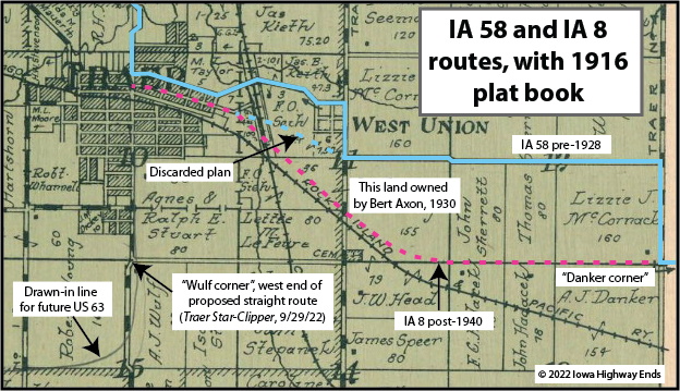 Note that F.O. Sieh’s name is misspelled in one place (between the blue lines), and correctly spelled in another (to the right of “Discarded plan”). The 1928-40 connection ran west from the center of section 11 to the railroad tracks, and today is the gravel road on the south side of the North Tama Athletic Complex.
The map above is a version of the map on my IA 8 page, which I also updated.
This is a lot of work for figuring out a mile of road, and that’s even with my obvious familiarity with this area. But it’s emblematic of what I run into all over the state as I try to figure out routings that many times were gone within a decade after they started. (See IA 31 at Smithland.) There’s no way I could have done this even in 2010.
(One detour during research in this saga: The Standard Oil Company bought a property at the intersection of First and Walnut streets, which is a block north of the business district, in September 1919 and planned a gas station there. In March 1921, the Traer Star-Clipper reported the company “made a mistake in the purchase of a site” and wanted somewhere else instead. By the end of 1930 Traer had six gas stations. Three were at the intersection of Main and First, a block north of IA 8’s west end. One, at the intersection of Second and Linn streets, presently houses the Traer Ambulance Service. One is the present Sinclair station on the north side of town, and the last on the south side of town was known as Gas-N-Grub in the late 1990s but has been closed for nearly two decades.)