
The City Development Board approves actions related to municipal boundaries in Iowa, which makes it an important source for annexations and discontinuations. The board’s website is pretty good at posting agendas and minutes, but no additional information is included. This makes it tricky when I see an entry for an annexation and have no idea what area of land is being talked about.
For example, the September minutes included annexation items for Sioux City, North Liberty, Fairfax, Cedar Rapids, and Des Moines. This point is where I have to start digging into city council minutes and hope the cities in question have “best practices” on public records. I also have to kind of guess that I have the “right” annexation when it comes to cities that do it on a regular basis. I’ve asked if maps could be included on the CDB’s website and was told that won’t happen.
This blog post is going to talk about what might be the smallest addition ever to Iowa’s largest city. It’s not an empty space for building a dozen houses. It’s not one house. It’s not even an alley. It’s the space between the Days Inn and south side of the Taco Bell parking lot on Merle Hay Road. If you scan around on Street View there’s one tiny clue of the change between Des Moines and Polk County jurisdiction: The curb on the frontage road disappears.
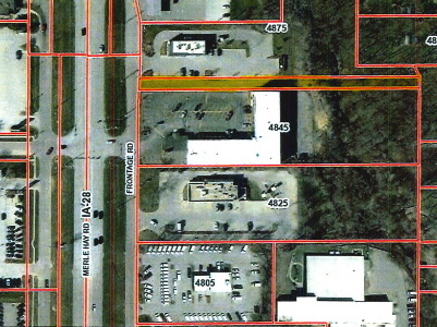
A Des Moines City Council packet from June 12, about a hearing on the annexation, highlights the parcel on Page 3 (above). The right-of-way parcel for Merle Hay Road adjacent to it is at/near Des Moines’ northernmost extent.
The only way Des Moines can expand northward is through small acquisitions like this, although this one is really tiny. East of the Des Moines River, most of the city’s northern border has been stuck at Aurora Avenue since 1890. The GIS map for the county at NW 6th Drive, for example, shows the teal city border running down the middle of Aurora Avenue. Each parcel is outlined in red.
If we assumed each house was on an equal-sized portion of land (they’re not, but work with me here), an “80/20” annexation means 4 of 5 landowners in a given area would have to want to be annexed by the city. Each individual landowner could request annexation, but the city isn’t going to grow by leaps and bounds (or even tens of acres) that way. This also explains why Ankeny keeps adding to its southeast but can’t swallow Saylorville.