Jun 05

New IA 330 interchange plans released

There’s the obvious one, an interchange at the present intersection, and the expensive one, an interchange between the intersections with a sort of frontage road on the east side.

Posted in Construction | Comments Off on New IA 330 interchange plans released
Jun 03

Map exhibit at Figge Art Museum

I took advantage of one of the few days that didn’t have much rain in it to go to Davenport and see the exhibit “Marking Territory: Cartographic Treasures of the Mississippi River and the World Beyond.” It’s around for two more weeks.

I have to say it was a mixed bag at best. I loved seeing the old maps. However, this is an art exhibit, not a map or history exhibit. The maps aren’t in much of a chronological order and documentation was skimpy at best and included little that was Iowa-specific. The narrative that does exist clearly has an agenda/perspective, not unlike the American West and Regionalism galleries elsewhere in the museum. (The text at the links is the text at the entrance to each gallery.)

Elsewhere in the museum, the most interesting pieces may have been the “blueprints” for Wayne Manor and the “Brady Bunch” home” along with a map of Mayberry in the Pop Art exhibit. On the other end of the spectrum, there’s … this.

Posted in Maps | Comments Off on Map exhibit at Figge Art Museum
Jun 02

“We’re not interested in Iowa State”

Not necessarily news, but interesting nonetheless. This selection from Gordon Gee’s comments come around the 11:38 mark, right after he says there’s no way the Big Ten would take Cincinnati or Pitt. (SI’s Andy Staples has excerpts right before and after. When you read this, Gee calls it Missou-ruh.)

“One of the problems we face is that Iowa has tremendous pressure about Iowa State. We’re not interested in Iowa State. We are interested in Missouri and Kansas eventually, I think. … I would see potentially Missouri and Kansas. By the way it goes without saying this all has to be speculation that remains right here.”

Mike Hlas has some more observations.

Iowa State didn’t need another reason to be disgusted with Ohio State, or the Big Ten in general, but there you go.

Posted in Sports | Comments Off on “We’re not interested in Iowa State”
May 31

Google Maps, what have you done?

Over the last couple of years, Google Maps has steadily been encountering feature creep and some decreases in quality. Yesterday, things took another turn for the worse.

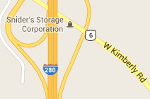
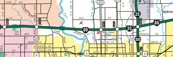
  • The point size of all route markers has been decreased. It’s much more difficult to read. I keep clicking to zoom in some hope they will become bigger. In addition, the numbers do not line up! See, for example, below:

gmaps_may2013 gmaps_may2013.2

Look at the numeral “1”. It is a little taller, or starts a pixel higher, than the others. In addition, it’s not kerned correctly. These images key along to the next points:

  • Route numbers are not centered properly. Look at how the “2” in I-280 touches the edge, and how a single-digit US 6 isn’t aligned. US 61 (not shown) is too far to the left. This is literally a one-pixel issue, and it may take some eyeball adjustments by an actual person to tweak.
  • The Iowa road name dataset is sorely outdated. Many of the spur routes from the Second Great Decommissioning appear on the maps — they’ve been dead for nine years and 11 months — and there are some from the 1980s. IA 233 east of Albion and IA 311 east of Liscomb are still there.
  • The Iowa road name dataset is missing county roads. Unless the road was named as such in the E911 system, a county road designation does not appear anywhere. And even in places where that IS the case, Google is attaching the county road designation it “should” have. For example, E69 in southwestern Tama County is not labeled E69 at all, but 390th Street.
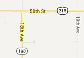
  • Some designations are just plain wrong. Even when IA 198 and IA 394 were alive, they never went north of US 218 or Donnellson, respectively, but at least one marker appears.
  • The US shield design, which has been messed up for a long time, still hasn’t changed. This may have a bearing on the centered-number issue above, although it affects numbers on any shield.
  • Style conventions are inconsistent. City names start out lowercase but become all-caps at the 2000-foot zoom level. These names, although bold, are in a smaller point size than the street and landmark text, which may also have changed. Park/lake names are now italicized when they didn’t use to be (which isn’t inconsistent so much as another aesthetic change).
  • And for the love of Rand and McNally, why can’t there be a toggle for county lines?!? Mapquest has displayed them for 15 years!

I’ve searched for a general feedback page or e-mail address, but can’t seem to find one. (Ironic, yes?) The errors are too widespread and systematic to narrow it down to a specific location and say “Report problem here.” I don’t know what’s going on in the Googleplex, but perhaps the team needs a road geek or two.

Posted in Maps | Comments Off on Google Maps, what have you done?
May 30

Census redefines metro areas

At the end of February, the census put out new lists of metro areas based on the 2010 census. The metropolitan (>50,000) and micropolitan (>10,000) areas are drawn up based on “a high degree of social and economic integration with the core as measured by commuting ties.” That means counties with commuters to multiple surrounding areas, such as Cedar and Tama, don’t get included in any of them. The Census Bureau noted that it had changed the definition of Combined Statistical Areas, which affected Iowa too. The only map available online is pretty rough, though (PDF).

West Des Moines officially got equal billing with Des Moines at the end of 2005 (PDF) after reaching 50,000 population. Here’s how things stand now, with changes in bold:

  • One-county micropolitan areas: Boone (Boone), Clinton (Clinton), Fairfield (Jefferson), Fort Dodge (Webster), Marshalltown (Marshall), Muscatine (Muscatine; Louisa is out), Newton (Jasper), Oskaloosa (Mahaska), Spencer (Clay), Spirit Lake (Dickinson), Storm Lake (Buena Vista). Pella (Marion) is off the list.
  • Multi-county micropolitan areas: Burlington (Des Moines and Henderson IL), Mason City (Cerro Gordo and Worth), Ottumwa (Wapello and now Davis). Hancock County IL has been added to Lee IA and Clark MO for Fort Madison-Keokuk, creating a three-county, three-state micro area.
  • Metropolitan areas entirely within Iowa: Ames (Story), Cedar Rapids (Benton-Linn-Jones), Des Moines-West Des Moines (Polk-Dallas-Guthrie-Madison-Warren), Dubuque (Dubuque), Iowa City (Johnson-Washington), Waterloo-Cedar Falls (Black Hawk-Grundy-Bremer).
  • Metropolitan areas on the border: Davenport-Moline-Rock Island (Scott plus three in Illinois), Omaha-Council Bluffs (Harrison-Pottawattamie-Mills plus five in Nebraska), Sioux City (Woodbury and now Plymouth, two in Nebraska, Union SD). Also of note, Fillmore County MN, which borders Iowa, is now part of the Rochester MSA; Houston County MN in the southeast corner remains in the La Crosse WI MSA; and all three South Dakota counties that border Iowa are in MSAs (Union with Sioux City, Minnehaha and Lincoln with Sioux Falls).
  • Combined Statistical Areas: Cedar Rapids-Iowa City is a new five-county CSA. Des Moines-Ames-West Des Moines is a six-county CSA, replacing Ames-Boone and Des Moines-Newton-Pella. Clinton, Muscatine, and Scott counties are in a new Davenport-Moline CSA, three counties in Iowa and three in Illinois.
  • All told, 38 of 99 counties are in metropolitan or micropolitan areas.

I wonder if the closing of Maytag was a major factor in the central Iowa change. Also, it’s likely only a matter of time before West Des Moines bumps Ames in naming position.

Posted in Maps | Comments Off on Census redefines metro areas
May 29

Huebinger 1912 Auto Trail Guides and old county atlases

I may be a teensy bit excited about discovering this resource.

Notice that one is called the Transcontinental Route because the Lincoln Highway wouldn’t be born until the next year and wouldn’t be recognized in Iowa until 1915.

Full county plat book list. Many of these were mass-produced by the same company, which explains why they include census tables and a map of the Panama Canal(!) at the end.

Direct link to the 1916 Tama County Atlas

Posted in Iowa Miscellaneous, Maps | Comments Off on Huebinger 1912 Auto Trail Guides and old county atlases
May 28

Quest for 100

The 2012 city estimates by the Census Bureau show that Des Moines, with a population around 206,000, is the 104th largest city in the nation. It trails Birmingham by about 5,500.

Wouldn’t it be nice to be in the top 100, especially for promotional purposes? Is there an easy way to get there, or at least closer? Yes and yes. After seeing the suburbs continue to eat into Dallas County, it’s time for Des Moines to do some annexation of its own. The city added a bunch of land to the east and south in the last decade near the US 65/IA 5 beltway, even into Warren County, but one obvious strip visible in the map below remains ignored.

DMmetroannex

All that white space between Aurora Avenue (42nd Avenue) and I-35/80 has remained a part of Polk County for decades after the interstate was built. Because of this, technically, I-35/80 does not run through Des Moines. In the far right of this clip you can see the post-2009 city limits extend near there, but the city map (PDF) shows they stop at the right-of-way instead of the median/centerline. (Why? Beats me.)

The catch is, because the area is already populated, it would probably take a majority of property owners or residents agreeing to the annexation before it happened. The last annexation was largely an involuntary one, and it took a decade to become reality. That purple in the map is Ankeny creeping downward to grab more open space east of I-35, and who knows what other plans are in store.

On the surface, it seems logical. The area already has infrastructure, although there is the question of who is more responsive to repairs/upgrades, the city or the county. It would give the city more control over how it is presented to travelers coming south off the interstate. (Two words: Big Earl’s.) Finally, it would clean up the seeming geographic oddity of the land there not being part of Des Moines. On the other hand, tax rates would be a factor.

(And while we’re at it, Johnston and Urbandale, can you figure something out for that parcel northeast of 86th Street? It looks silly. Thanks.)

Posted in Geography, Maps | Comments Off on Quest for 100
May 26

Carving up Clearfield

OLYMPUS DIGITAL CAMERA
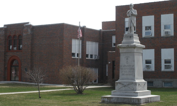
April 1, 2010: The stone soldier out front couldn’t guard against a century and a half of demographics. (Note: He faces north.)

Clearfield is the only school in Iowa I know of that has a Civil War monument on its grounds. Despite not even being incorporated until the 1880s, this town 16 miles from the Missouri border managed to get its own.

But the town’s population peaked in 1900 — a statistic that is not uncommon in Iowa. Today, it has a population of only 363, down from 698 at the turn of the previous century.

For years after losing the high school, Clearfield soldiered on. Likely because of its location, both centralized and isolated among four other districts, it let students in seventh grade and up enroll into their school of choice. But now, like districts on the opposite side of the state, holding on for dear life is no longer an option.

None of the four districts surrounding Clearfield — Bedford, Diagonal, Lenox, and Mount Ayr — were interested in a full merger. For Diagonal it wasn’t even an option; combining the second-smallest and fourth-smallest school districts in the entire state wouldn’t come close to a 300-student threshold.

Dissolution of a school district is rare in Iowa, but in this corner of the state it’s happened twice. Grand Valley, which straddled the Ringgold-Decatur county line, dissolved in 1998, divided up between Central Decatur and Mount Ayr. New Market, which straddled the Taylor-Page county line, dissolved in 2008, divided up between Clarinda and Bedford. Clearfield, right in the middle, will follow in 13 months.

Iowa gives a district great latitude in deciding the manner of its demise unless it repeatedly falls short on finances, including deciding where students will go. That, in turn, means already jagged school boundaries largely determined in the 1950s don’t get smoothed out when the opportunity comes.
Clearfield2

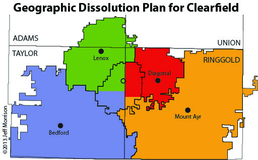
This map is what I would propose as a way to divide Clearfield’s students. The county line runs north-south. To the west, the border is on 190th Street, and to the east, it is on the half-mile between 210 and 220th streets. This gives Diagonal and especially Lenox a greater number of students because small schools can use all the help they can get. It’s clean, simple, and totally not going to happen.

See that squiggle to the far east? That’s Mount Ayr snaking into the town of Grand River after Grand Valley went kaput. See the dents in Bedford’s west? That’s Clarinda poking into the remains of New Market. Even when given a golden opportunity, not only did borders wind up as skewed as ever, the towns themselves got carved up.

This article in the Mount Ayr Record-News gives the impression that the same thing is going to happen again. By certified enrollment, the district has 69 students on the Taylor County side and 13 on the Ringgold County side. The Record-News says Mount Ayr is a front-runner in preference for the east side of the district and the town kids are split between it and Lenox.

Although we’re only talking about 13 students here, extending Mount Ayr’s boundaries up the west side of Ringgold County could put some psychological pressure on tiny Diagonal. I say could, because Diagonal has been pretty darn tenacious and being surrounded on three 2½ sides by Decorah hasn’t made North Winneshiek buckle yet. (I still say that if doomsday does happen there should be a name change wrangled out of it.)

The other big question is what happens to the Clearfield building itself. If it’s not sold, whichever district gets that land will own it and want to unload it as soon as possible. The Record-News says the dissolution plan includes money for demolition — in effect, putting aside money for its own funeral.

How would Clearfield students in town react to going to districts far apart from each other? Could the Clearfield school building become the new headquarters of the Lions Club there? The Lions Club is the town’s most-known feature, running the shuttles at the Iowa State Fair. What will happen to the statue? In the next 13 months, a 132-year-old school district must find the answers to these questions as it prepares to fade into history.

Posted in Schools | Comments Off on Carving up Clearfield
May 24

Iowa highway map press release

Just in time for Memorial Day weekend, although two months behind the normal schedule.

Kendallville is an unincorporated place on IA 139 five miles from the Minnesota border, BTW.

Posted in Maps | Comments Off on Iowa highway map press release
May 23

2012 Iowa city population estimates

After you’ve gone through the rigamarole in my earlier post, you will be able to see the actual numbers. Here are some quick hits from the 2012 city population estimates. Most of these are not radical changes from 2010 yet, of course.

  • 2,435,611 Iowans live in incorporated places, an increase of about 30,000 from the 2010 census, and 79% of the overall state population in the 2012 estimate.
  • Half of all Iowans who live in incorporated places live in the 20 largest cities (see bottom for specifics).
  • Pella becomes the 39th city in the state with a population above 10,000. Those 39 have a combined population of just over 1.5 million.
  • West Des Moines continues to make a serious run to supplant Ames as the eighth-largest city.
  • Since April 1, 2010, 4500 people (the entire town of Hampton, itself the 89th-largest city in Iowa) moved to Ankeny.
  • Tabor joins Keosauqua and Odebolt in falling under 1000.
  • Every town in Tama County has lost at least a few people except Vining, which stayed at 50.
  • The median-population city (half have more, half have less) is Martensdale, pop. 464.
  • The 20 largest cities in the state have a combined population of 1,230,334 (50.5% of the city total), while the rest total 1,205,129. Move Ottumwa into the second group and it becomes the larger one.
  • That means that 40% of the entire population of Iowa lives in 20 cities.
Posted in Iowa Miscellaneous | Comments Off on 2012 Iowa city population estimates