Apr 02

Walcott visitors center open

The welcome center at the World’s Largest Truck Stop replaces the one that closed in LeClaire.

The move is actually  beneficial for travelers because now no matter how you come in to the Quad Cities, there is an eastern Iowa I-80 welcome center available.


Posted in Highway Miscellaneous | Comments Off on Walcott visitors center open
Apr 02

Early history of each Iowa county

I’ve been looking for county information for a new project (great, but shouldn’t you be working on your old ones? -Ed.) and found that the Iowa Association of Counties digitized a book with a few paragraphs and important dates in each county’s early history. (The “%20″s in the link are spaces. Bad HTML form.) There is also a PDF version of the whole book, published in 1992.

There are some neat little gems in there. I was amused by this one from Ringgold County: “Then in 1884 a large brick building was completed from bricks made and fired in this county.  …  Inferior brick and lack of drain tiles caused such large cracks that it was condemned as unsafe in 1921.”

And Wright County: “In an 1890 election the voters approved the building of a new courthouse and jail. When the results were released to the public there was much celebrating done. Some of the residents of Clarion were so excited that they soaked the jail in oil and set it on fire.”

Posted in Geography | Comments Off on Early history of each Iowa county
Apr 02

Photos by the numbers: 152

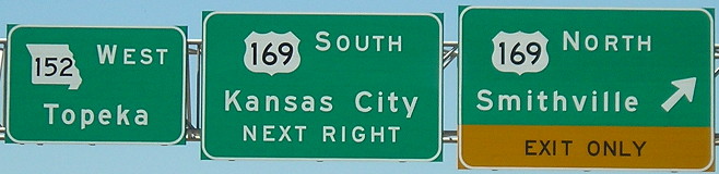
August 3, 2010: In the 1990s and 2000s, Missouri upgraded MO 152 to be a four-lane connector between I-29 and I-35 on the north side of Kansas City, but south of the airport. The use of Topeka as a control city is a little sleight of hand: MO 152 ends at I-435,  4 miles from the Kansas border, but MO 152/I-435/I-70 is a good way for Topeka/eastern Kansas traffic to get to I-35 without going through downtown.

Posted in Sequences | Comments Off on Photos by the numbers: 152
Apr 01

Without a net

Fifteen years ago, give or take a few months, I set up my first live website. For the first five years, I didn’t do much with it, setting up a few pages about the Titanic movie (!) and a couple road odds-and-ends but not much else.

In November 2001, I set up Iowa Highway Ends there, and in short order it became large enough that I exceeded the 20 MB (!) limit and needed a second sub-site. Soon, I had to start storing photos on my iDisk, requiring a manual re-edit of many pages to create absolute links.

A few years ago, I decided to move everything exclusively to my iDisk, after Angelfire’s interface failed to change. It was more efficient.

But then, last year, Apple lowered the boom. Join iCloud! Apple says. Except there’s one problem — probably because now that everyone uses templates or third-party sites (or, sigh, Facebook) to hold all their pictures and do their page work for them, Apple decided against a web-hosting service.

So ninety days from now, everything at homepage.mac.com/jeffmorrison — more than a decade’s worth of stuff — disappears forever. It might be the biggest purge of the Internet since Yahoo closed Geocities.

That’s why this website was created.

I think I’ve moved everything, and notified everyone I can think of, but there’s only one way to be sure. That’s where the self-imposed “link rot” comes in. The Angelfire pages have remained up, but the accumulation of minor edits to all of them have resulted in un-updated, or worse inaccurate, information.

So today I took a big step. I logged in to Angelfire for the first time in a really long time and found a new interface … that I won’t be interfacing much with. And, in the sub-site, I batch-deleted file after file, files that took untold hours to upload but seconds to go away.

I’m already having second thoughts, but it is one of those things that should be done. In a week or two I’ll go in and delete a chunk again, and hope that everyone who gets a 404 will be able to point to this place.

Posted in Uncategorized | Comments Off on Without a net
Apr 01

Photos by the numbers: 151

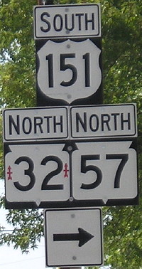
August 10, 2007: Wrong-way multiplex for US 151, WI 32, and WI 57 in Chilton, Wisconsin. This isn’t the only time 151 is contrary; in Cedar Rapids, US 151 and US 218 have a wrong-way triplex with US 30. The arrows on WI 32 are for the 32nd Infantry Brigade of the Wisconsin National Guard.

Posted in Sequences | Comments Off on Photos by the numbers: 151
Mar 31

A dose of thoroughly useless data

The east-west part of Chicago’s Dwight D. Eisenhower Expressway, aka “the Ike” or I-290, which turns into Congress Parkway in downtown, is about one mile north of the Monona/Harrison-to-Linn/Johnson county line. (About 41°51’N.) In fact, if you add five to longitude numbers in downtown Chicago, you will find yourself in southern Tama County along County Road E69.

Much of the Chicago metro area is in the latitudes between US 20 and I-80 in Iowa; US 20 dips southeast starting at Rockford to go into the city.

This isn’t particularly ground-breaking, but I was playing around with some numbers after I took the Jeopardy online test.

Meanwhile, this weekend Google is offering “8-bit mode” for “quests” like on on Nintendo games. These two characters are hiding north of the Chicago Loop.

Posted in Geography | Comments Off on A dose of thoroughly useless data
Mar 31

Photos by the numbers: 150

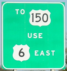
April 18, 2006: Guidance on I-280 approaching I-74. At a cloverleaf interchange on the south side of the Quad Cities, US 6 leaves I-74, then turns east at the airport, and then intersects US 150. US 150 used to go into Rock Island and end at least within sight of the state of Iowa, but the exact circumstances of its end are unclear. IA 150 was created in the hopes that it would become an extension of US 150, but it runs north-south instead of northwest-southeast line US 150. Now, of course, 150 has been removed completely from far eastern Iowa and ends in Vinton.

Posted in Sequences | Comments Off on Photos by the numbers: 150
Mar 30

Photos by the numbers: 149

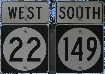
October 13, 2006: South English. Keokuk County has seven state numbers — 1, 21, 22, 23, 78, 92, and 149 — but no US routes. (It also had IA 77 until 2003.)

Posted in Sequences | Comments Off on Photos by the numbers: 149
Mar 29

Photos by the numbers: 148

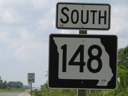
August 21, 2006: Sign at the Missouri state line, 13 miles north of its south end near Maryville. Even-numbered highways in Missouri conventionally run east-west, but this is an exception because it was created to continue from an Iowa number. It was MO 27 until 1968.

Posted in Sequences | Comments Off on Photos by the numbers: 148
Mar 28

March’s US 63 news

This was in one of the links of the map post, but I thought I’d break it out: The House approved a bill that would add the segment of US 63 between Ottumwa and Waterloo to the Commercial and Industrial Network. So far, the roads with this designation are identical to the ones enrolled in the National Highway System. All that a layperson would notice with this is that the rest of 63 would be red on the state map instead of black.

Meanwhile, although the Kirksville bypass is done, the 60-odd miles between there and Ottumwa will remain a bottleneck. KTVO has a report on some progress there — very, very preliminary progress. (I think they went a little overboard on the tagging under the video.) And Kirksville is already thinking about expected development on new 63 — so in 30 years we’ll have to do it all over again.

Posted in Construction | Comments Off on March’s US 63 news