Aug 17

Final loop ramp at 80/380 interchange to close


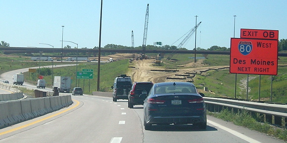
August 16, 2021: Looking straight ahead as the freeway bends, you can see the grading for the ramp from southbound I-380 to eastbound I-80. There’s also grading for the future ramp to westbound 80.

The I-80/I-380 interchange project has reached a big milestone: The final interior loop ramp from the original construction is shutting down.

According to an e-mail from the Iowa DOT, the new flyover ramp from southbound I-380 to eastbound I-80 will open Friday. The PDF is here, but its address indicates that it’s one that will change for other updates.

For now, the Exit 0B and 0A designations for the ramps to Des Moines and Iowa City remain intact, because there isn’t a unified exit point before a split. However, the Iowa City exit will now come before the Des Moines exit. The flyover ramp goes over I-80 but then under US 218 before merging with I-80 near the Clear Creek bridge. Here is a full diagram of the finished interchange.

Posted in Construction | Comments Off on Final loop ramp at 80/380 interchange to close
Aug 15

Mixmaster meeting focuses on I-80 east of interchange

Information on another stage of the Northeast Mixmaster was released online and in a public meeting August 9. This project is about expanding I-80 between I-35 and US 65.

The PDFs are here. The expansions shown in the “full build” — adding lanes on I-80, widening or replacing bridges, and making northbound 65 to westbound 80 two lanes — are years in the future. The grading/bridges component is programmed for 2024, according to the short video linked in the meeting.

Posted in Construction | Comments Off on Mixmaster meeting focuses on I-80 east of interchange
Aug 12

The names of the BCR&M live on


October 12, 2021: Two intersections in Walker, in northern Linn County.

Ely has streets named Dows, Rowley, Traer, and Walker. Walker has streets named Dows, Ely, Greene, Rowley, and Traer. Mount Auburn has a Traer Street. Rowley has a (very short) Ely Street. Greene has sequential streets named Ely, Dow (no S), Traer, and Rowley. Only Dows and Traer do not have streets named for these other towns. (Traer has a Green, but not a Greene.)

What these towns all have in common is being stations on the Burlington, Cedar Rapids & Minnesota Railroad, which lasted less than 20 years before being folded into the Burlington, Cedar Rapids & Northern. In 1903 the BCR&N became part of the Chicago, Rock Island & Pacific.

Here’s an excerpt from the Traer Clipper (Volume 1, No. 25) on June 19, 1874:

George Greene, the namesake of Greene, is a notable figure in Iowa history* before his time with the railroad: He was a territorial legislator, one of Iowa’s first state supreme court justices, and a founder and surveyor of Cedar Rapids. (That means he’s also to blame for the street grid. Nobody’s perfect.)

Ely’s sesquicentennial celebration is this weekend; Traer’s is one year from now.

*General Assembly “-5” in the weblink, as part of the territorial legislature. Cute.
Posted in Iowa Miscellaneous | Comments Off on The names of the BCR&M live on
Aug 10

We’re not getting the tram back, are we?

The Iowa State Fair killed off the interior tram last year, said nothing about it coming back, and kept the official website on a “safety protocols” wording that might have passed last year but not now. It’s up to a KNIA/KRLS story from last month about the Pleasantville FFA’s volunteer operation to tell the truth:

“Last year the indoor trams were cut due to covid and funding issues so we only did the trams outside of the fair,” Pleasantville FFA Alumni President Marris Clark told the radio stations. The tram “outside the fair” is a shuttle that runs back and forth across the parking lots on the north side of the fairgrounds.

You’d think that providing an important service to fairgoers — an essential one if you’re over 60 and interested in going to Pioneer Hall or the Cultural Center — would be something to keep active, but I guess not. At least the campground shuttle is still active, even though its endpoint moved from the Triangle to Heritage Village years ago.

Posted in Iowa Miscellaneous | Comments Off on We’re not getting the tram back, are we?
Aug 08

I-74 bridge has different type of lane markers

Last month, WQAD did a story about the lane markers on the I-74 bridge. Each white line has a black counterpart and is called “contrast marking”. The story says the Iowa DOT is planning to add this type of marking to Iowa interstates over the next five years.

The video is embedded above, but is a set size and so the whole thing might not be seen. The video on the website does NOT autoplay.

Posted in Construction | Comments Off on I-74 bridge has different type of lane markers
Aug 03

Public meetings on two big projects coming up

A project 40 years in the making and project that only seems like it will have been 40 years in the making are in line for Iowa DOT public meetings in the next week.

An in-person hearing on the US 30 Missouri Valley bypass is tomorrow in that city. A bypass was first proposed in the 1980s and got so far as to be included on five-year plans, then was shelved following an Army Corps of Engineers study and public opposition in 1991.

But non-construction then, plus lessons learned from three decades of intermittent flooding, offers an opportunity. “The timing of the Iowa DOT and USACE projects creates the potential to combine a portion of the new levees in the same location as the new US 30 corridor using a single embankment that combines the levees and roadway,” says the environmental assessment that is online already (large PDF).

The bypass on the south side of Missouri Valley will start just east of the I-29 interchange and end near the F58 intersection just south of the Welcome Center.

The other meeting, scheduled for next Tuesday, is about the Northeast Mixmaster in Des Moines. Work is imminent on the most pressing need, the I-35 northbound flyover ramp. A virtual meeting (and, I hope, PDFs) will be available online that day and afterward.

Posted in Construction | Comments Off on Public meetings on two big projects coming up
Aug 01

‘Iowa is the most Midwestern state in the union’

If you’ve read the book, or walked/drove around last week (this week not so much), you already know that the Midwest is God’s gift to Planet Earth. But, in a region spanning from the Badlands to Appalachian Ohio, how can we tell the MOST Midwestern place of them all?

Well, the Washington Post has statistically(ish) proven that it is none other than the Hawkeye State, based on having the most Airbnb entries that include the term “Midwest”.

Three of the “most Midwestern things on the planet”, according to the analysis, are fish-related, and the tenth is “supper”, as is right and proper. “Blacktop” is also in there, and while there is a technical difference from asphalt, especially south of IA 92 in Iowa and on nearly any lettered road in Missouri, it’s often simply a synonym for a non-concrete/non-gravel road. As for “rehabbed” I think that’s more a watched-too-much-HGTV thing than a Midwest thing.

But it’s clear the Post has never been to Kalona, or Cantril, or Hazleton:

“Amish” may seem surprising, given their deep roots in Pennsylvania, but the Midwestern states of Indiana and Ohio have some of the country’s largest Amish populations, with smaller groups of the old-school Anabaptists spread throughout the Midwest Farm Belt.

Cantril is home to the Dutchman’s Store, after the Pennsylvania Dutch.

On a recent Sunday drive I happened to go through the Kalona area and saw more buggies than ever before — at one point, three in the rearview mirror and one in front of me. The buggy riders and I shared the same feeling: We knew it was a day the Lord had made, and we would rejoice and be glad in it — and wave when we passed each other on the road.

Posted in Iowa Miscellaneous | Comments Off on ‘Iowa is the most Midwestern state in the union’
Jul 29

Two new ‘corridor preservation zones’ assigned

The Iowa DOT has put out a “corridor preservation notice” for two areas along four-lane roads. “Corridor preservation is a tool the Iowa DOT uses to preserve land for future highway needs,” the press releases say. One location is an interchange we know is coming, and one is for an intersection that, for now, will remain so.

The first preservation zone is at the X20 intersection in Springville. Interchange proposals here were already in the public presentation stage nearly a decade ago. I can’t find earlier notices if there were any, so/but doing it now seems really delayed.

The second preservation zone is on US 20 east of the Peosta interchange. The press release does not mention an interchange. However, the newest five-year plan includes “grade and pave” at the Cox Springs Road intersection in the preservation zone. This area had an issue three years ago (KCRG), when construction of a subdivision closed a nearby road, and the city of Peosta wasn’t in complete control of the situation because the developer built the road. There was a non-fatal accident at Cox Springs Road in 2018.

Posted in Construction | Comments Off on Two new ‘corridor preservation zones’ assigned
Jul 27

Eldora school demolished 15 years after closure

Every once in a while for a long time I would check the Eldora newspaper’s website to see if there was any progress on demolition of the 1916-17 school building. Nothing kept happening, so I let it slide. But after the Gladbrook school finally came down this summer, I thought about it again.

It was demolished earlier this year, according to news story snippets from late March and mid-June. Both the Eldora Herald-Ledger and Iowa Falls Times-Citizen websites only display a few sentences before a paywall kicks in, but that was enough for me to see…

HEY THAT’S MY PICTURE!! A photo of the side of the school with all the windows boarded up, taken in 2015, was posted on this blog in April 2017 and printed in the Times-Citizen on March 23 without my knowledge. Eldora Historical Society, would you like to explain yourself?

Based on a T-C snippet and Iowa Department of Education building lists, it looks like I was a year off on the beginning of Eldora-New Providence and Hubbard-Radcliffe starting sharing as South Hardin, so that has been corrected in the timeline to 2007. Based on a snippet from the H-L in May, the gym continued to be used after the school was closed. It was built in 1958-59, according to an application to get Eldora’s downtown on the National Register of Historic Places, and the minimal connection between the two structures would have permitted continued use.

(I didn’t intend to write about two cases of reproduction-without-notification, but they just happened to crop up within a few-day span.)

Posted in Schools | Comments Off on Eldora school demolished 15 years after closure
Jul 25

A RAGBRAI database, with some assistance


June 19, 1977/October 3, 2010: A daily map for RAGBRAI V, photographed from microfilm. The 1977 and 2022 routes share some similarities, including an overnight stop in Ida Grove, a route south of US 18 from Whittemore to New Hampton, and an end in Lansing.

Back when I was working at the Des Moines Register, I wondered if there was a compilation of all the RAGBRAI towns, or even all the routes. The answer appeared to be no, so I did what I do best and started digging through archives. I knew/found out when town maps were published (June in early years, or each day during the ride, eventually moving to a full map on the third Sunday in March). I created an internal database and then a simple list of towns for each year, as shown in the Register’s maps. I uploaded the compilation of the latter 10 years ago Saturday and have updated it ever year since.

Well, it appears this work has not gone unnoticed. Needless to say, the Register’s database is fancier. I’d like to think my list’s presentation has its own strengths, though. I suppose this counts under “turnabout is fair play” — after all, the lists were compiled from the newspaper in the first place. There is a credit, which I appreciate greatly.

Back in the halcyon days of blogging, there was a code, exemplified in this book from 2008: “the true coin of the realm in the blogosphere is links. … As a general rule, the more bloggers who link to your blog or to your individual posts, the more influential you are as a blogger.” (The book was rendered obsolete almost immediately, as Facebook ate nearly the entire blogosphere during Obama’s first term and Google strangled RSS in 2013. Now Safari doesn’t even have built-in RSS.)

I’m glad my information is being found useful, but an e-mail and a link about it would be appreciated along with a credit.

UPDATE 7/28/22: A couple locations I wrote in a specific style are replicated that way in the database. Hmmm.

Posted in Iowa Miscellaneous, Maps | Comments Off on A RAGBRAI database, with some assistance