
Cause of death: Progress. This is only 10 months after the US 30 bypass/bisection of Tama/Toledo opened.
The King Tower was on the easternmost part of 30 that was bypassed, part of the original Lincoln Highway, near the bridge.
Cause of death: Progress. This is only 10 months after the US 30 bypass/bisection of Tama/Toledo opened.
The King Tower was on the easternmost part of 30 that was bypassed, part of the original Lincoln Highway, near the bridge.
The Woden-Crystal Lake-Titonka softball team lost Wednesday night to North Sentral Kossuth/Armstrong-Ringsted, closing the door on the last part of that school district.
NSK/AR is, itself, a shared program of two schools, which were three only a decade ago. (Talk about acronym overload.)
Technically, it’s called a “derecho.”
As the system passed through the northern Des Moines metro area at 3:30am, it rapidly intensified and accelerated eastward. Over the next hour and a half the storm plowed eastward through Story, Marshall, and Tama Counties, blasting the area with winds of up to 105 mph, the equivalent of an EF1 tornado.
There was widespread damage in Tama and Marshall counties and beyond. Part of the Traer Manufacturing building got ripped apart, potentially having long-term implications for attempts to get something there in the future.
Delayed many years by budget troubles and one more year by rainy weather, US 30 is now four lanes from State Center to IA 330 – and, by extension, from Ogden to the casino in Tama County. It happened last week.
Meanwhile, heavy winds rolled across Marshall and Tama counties Sunday night. The Waterloo Courier has a slideshow of damage in Clutier and Dysart.
Now they’ll be even harder to tell apart from Minnesota’s.
The color of the print on newly issued Iowa license plates will change from blue to black starting next week.
Now at YMC, the standard plates have about a thousand permutations left. Actually, less, assuming that U and V are inexplicably skipped in second and third positions again.
Sometime between July(ish) 2010 (lower left)…
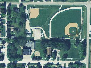 (Iowa Geo Info Server)
…and Wednesday, when I drove by and found stairs leading to an expanse of dirt.
The Algona Upper Des Moines recently had an article about reunions in nearby Ottosen. Livermore, Ottosen, and Bode joined up to form Twin Rivers in 1956, and then much later did whole-grade sharing with Gilmore City-Bradgate as Twin River Valley. But that came to an end in May, with the two districts going in separate directions.
Compare and contrast. From the official site:
Due to state budget reductions and advances in new driver-assistance technologies such as GPS, online driving directions and in-vehicle navigation systems, WSDOT is no longer offering paper copies of the state highway map.
From DailyTech.com:
According to the Washington State Department of Transportation, 623 collisions occurred within the state from 2006 to 2010 due to GPS units/computers. Two of these collisions were fatal.
Washington has had many GPS-related issues in the recent past. For instance, three women from Mexico used a GPS system to navigate their way to an Embassy Suites in Bellevue’s Eastgate area. They were in town for a Costco convention, and when driving back to the Embassy Suites in their Mercedes SUV around midnight, they turned onto Interstate 90 West instead of East, and made a turn off Bellevue Way Southeast. They were then led down the Sweyolocken boat ramp into Mercer Slough. The vehicle sank, but the passengers got away safely and slightly drenched.
There’s still a place for consulting a good old paper printout.
The Mississippi Valley Welcome Center, a one-stop source of information for visitors to the Quad-City area, will close after more than 20 years of operation.
The Quad-Cities Convention & Visitors Bureau manages the center, located on a bluff overlooking the river in LeClaire, Iowa. The bureau’s board of directors approved the closing Thursday.
I was just there, although it was closed at the time.
If this were THE westbound I-80 welcome center, it would be worse. Fortunately there’s still one in Wilton.
This will be a periodic feature. I’ll be keeping track of new letter combinations I see on Iowa license plates until we reach 999ZZZ and the system divides by zero. (This category will also apply to anything else plate-related.)
In the past week there’s been YIZ, YJA…and YMB? I assume that means that the YK’s and YL’s have been assigned far from Polk County, and not that entire sequences were skipped.
Note: Standard license plates with a first letter of D, I, O, Q, U, or V were never issued, as far as I have seen.
The State Data Center of Iowa’s website was redesigned just in time for release of the 2010 census data. The new site is completely dynamic without a single directly downloadable PDF or Excel file in sight. It does not seem to provide a way to get a simple table: A listing of Iowa’s cities in descending order by population, WITH a ranking, and NOT including Census Designated Places.
So I made one.
The 2010 census page is one of the last static pages on the old site. This is where the original files came from. I could explain the process, but the end result is what matters:
Iowa city population and rankings, in ranked order, 2010 (PDF)
Iowa county population and rankings, in ranked order, 2010 (PDF)
For data going back past 2000, the State Data Center is maintaining those files, at least for now:
Rankings from 2000 going back to 1850 (PDF)
Root page for multiple statistical compilations for cities
(This new site hasn’t even begun to sit upright, let alone crawl or walk, but if I’m going to put up link bait, this is a good place to start.)