Feb 20

Township population list misaligns certain numbers

While working on the Tama County Board of Supervisors post back in October, I wondered if there was a comprehensive list of populations of Iowa areas by township. This agglomeration of information, including cities independent of townships, is a building block for state legislative district maps. It’s also a data set to play with, and you know how much I love playing with data sets.

The good news is, I found a 2020 census township population list, on the Iowa Secretary of State’s website. The bad news is, once I got the PDF wrangled into a sortable spreadsheet, I found a misallocation of cells right away.

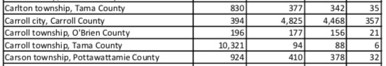
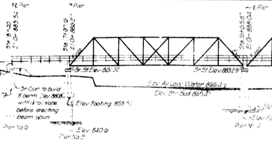
This is a clip from the original PDF. My conversion of the file to a sortable spreadsheet was a multi-step process using the Zamzar file converter, lots of copying and pasting, and a dummy CSV document to create separate columns for township and county.

The order in the row is subdivision, population, total housing units, occupied housing units, vacant housing units. Carroll Township in Tama County doesn’t have a single town, but this shows 10,321 people crammed into 88 houses. Imagine the line for the bathroom.

What has clearly happened is that the population for “Carroll city, Carroll County” has jumped lines with the townships in O’Brien and Tama counties. How do we know which township should have which number? Gannett papers had an excellent database that presented census numbers in many interesting ways. It appears to have vanished from the Des Moines Register‘s website, but it’s still active at the El Paso Times. Here we can find out that Carroll Township, Tama County, had a population of 196 in 2020. (It would take a month for all of them to move to Waukee.)

The same problem appears every time an independent city has the same name as a county township in the state:

  • Bloomfield (city, Davis; county, Clinton and Polk)
  • Carroll (city, Carroll; county, O’Brien and Tama)
  • Cedar Falls (city/county, Black Hawk)
  • Clear Lake (city, Cerro Gordo; county, Cerro Gordo and Hamilton)
  • Clinton (city, Clinton; county, Linn, Ringgold, Sac, Wayne)
  • Danville (city, Des Moines; county, Des Moines and Worth; the five cities in Des Moines County are independent from their townships)
  • Dubuque (city/county, Dubuque)
  • Eldora (city/county, Hardin)
  • Fairfield (city, Jefferson; 6 other counties)
  • Fayette (city, Fayette; county, Decatur and Linn)
  • Harlan (city, Shelby; county, Fayette and Page)
  • Humboldt (city/county, Humboldt)
  • Jefferson (city, Greene; 23 other counties)
  • Keokuk (city, Lee; county, Wapello)
  • Osceola (city, Clarke; county, Clarke and Franklin)
  • Sumner (city, split across Bremer and Fayette; 5 counties, and/but for historical continuity Bremer’s is officially named Sumner No. 2 Township in census data)
  • Waterloo (city, Black Hawk; county, Allamakee)

In every case, the problem can be solved by cutting the bottom-most cell in the name-set, selecting and moving the entire stack of numbers in the set down one cell, then pasting the previously bottom-most number at top in the “city” line.

The city of Carroll was separated from the townships around it in the summer of 1907, according to the July 2, 1907 Carroll Sentinel. The former Carroll Township was renamed Maple River Township. It’s not possible to know about this case on the modern DOT county map. On older ones, there was an additional “CARROLL” label in the township font. (And now I have learned that the DOT has redone its map website and the clickable drop-down lists are a little different.)

As this blog post goes live, the 2020 list with the incorrectly aligned data is still active on the SOS website. If anyone in state government is looking, hit me up and I can help you out.

Posted in Iowa Miscellaneous, Maps, Tama County | Comments Off on Township population list misaligns certain numbers
Feb 17

Marcus intersection will eventually get roundabout


July 23, 2009: Eastbound IA 3 at the south end of IA 143.

The intersection of IA 3 and 143 just south of Marcus is on the Iowa DOT’s horizon for installation of a roundabout.

The Cherokee Chronicle Times reports that “an abnormally high level of fatal accidents” has prompted the state to look toward a $4 million project. It’s not on the most recent five-year plan, but could get added to a future one.

There has been an increase in development in the area. Big flashing red lights have been added to the north-south stop signs, but IA 3 traffic remains free-flowing.

Unlike most roundabouts, this one is wanted by the city, the Chronicle-Times reports.

Posted in Construction | Comments Off on Marcus intersection will eventually get roundabout
Feb 15

Bellevue bond issue would keep 1848 building

Multiple bond votes in the 2010s to replace Bellevue Elementary failed. This time, the Bellevue school district has scaled back its construction proposal, and the complex with a building from 1848, where school has been held since 1861, would remain in use.

Phase 1, according to the school and the Bellevue Herald-Leader, would build an elementary for grades 3-5 on the site of the current school for grades 6-12. This is the part that requires a bond vote. Lower grades would stay at the current site until Phase 2, which would build an addition to the new elementary. That would be paid for entirely with PPEL/SAVE money, the district says, and would start around 2028.

The story and school both call the 1848 building “one of the oldest” in the state. But a quarter-century ago*, the Des Moines Register cited Bellevue Elementary as the oldest school building in Iowa. Working off a list with that story, Bellevue Elementary is Iowa’s only public school with classroom space from the 19th century in use in 2023. Of the others on the list of pre-1900 facilities:

  • All those in Sioux City were replaced in 2006 or the 2010s.
  • Burlington replaced one and sold the other to a private school, hence the “public” qualifier. History of Des Moines County, Iowa, Volume 1 (1915) pegs Prospect Hill School to 1892.
  • Decorah’s 1897 East Side Elementary was ordered closed by the state fire marshal in 1999. (Decorah Journal, 6/17/99)
  • Vinton’s 1898 East Elementary closed in 2002.
  • The oldest part of Sabula’s school opened in January 1883. It closed in 2013 when East Central merged with Preston and was demolished in the 2015-16 school year.
  • Des Moines’ Moulton Elementary School (old North High of 1896, according to a 1976 history of the district) is listed, but the oldest part today is from 1914.
  • “Moulton-Udell school boiler room”: I thought this was weirdly specific, but I found the answer: When Moulton’s 1897 school building was demolished in 1987, the Daily Iowegian said, “The basement of that building is being retained” (8/28/87). So technically there is a part of the Moulton complex that is 116 years old (in 2010s aerial photos, the white-roofed portion directly west of third base), but it’s not classroom space.
  • To the best of my knowledge, the next two oldest active public school buildings are Greenwood (1902) and McKinley (1905) elementaries in Des Moines. They are followed by Davenport Central High School (1907) and Des Moines East High School (1912, side facing East 13th Street).
    • Those are opening years, not cornerstone years. Whenever possible, because construction times vary, I’m trying to date schools to when they opened to students.
    • A brief in the January 31, 1907, Cedar Rapids Republican said a commencement ceremony in Davenport on January 29, “the first function in the new building,” had an incident between juniors and seniors that resulted in five expulsions: sons of the county school superintendent, school board president, music teacher, and two in “prominent families”.
    • The entrance to East bears a dramatic resemblance to Curtiss Hall at Iowa State University, built a few years earlier. Both were designed by Proudfoot & Bird/Proudfoot, Bird & Rawson, responsible for lots and lots and lots of landmark Iowa buildings.
    • Arthur and Garfield elementaries in Cedar Rapids, which opened in 1915, are scheduled to close in 2024 too.
  • We have plenty of the 1911-30 crop that has stuck around. (To wit.) However, many have been shuttered (but still extant) or replaced just since 1997. Newell’s 1912 building has been replaced in the past year, or if not it soon will be. Based on research so far, Blairsburg (1910) and Victor (early 1913) and are contenders for second-oldest rural school behind Bellevue.

*The August 31, 1997, Register made Historic Pages following a last-minute addition in the first edition that would later be updated: “Princess Diana hurt, boyfriend killed in car crash.”

Posted in Schools | Comments Off on Bellevue bond issue would keep 1848 building
Feb 13

Millions for special effects, but not one cent for proofreading

Forty seconds into this trailer for SyFy’s “The Ark” — it’s hard to tell because it’s small and pausing on YouTube puts the video controls over it — the word “maintenance” is misspelled on an ID badge.

This is not the first big-budget production to screw up on the little things. “Star Trek: Discovery” — which I only watched because CBS aired Season 1 (2017) during the pandemic — misspelled “protocols.” Put it in the okudagram hall of shame.

(Also, the word “representative” is misspelled in a hallway in a quick scene in “Joker”, but I don’t have a screengrab of that.)

(Related post.)

Posted in Uncategorized | Comments Off on Millions for special effects, but not one cent for proofreading
Feb 10

The winding history of the Sageville-Luxemburg road (2)


This clip from 1949 Iowa Highway Commission blueprints shows three alignments of IA 3 in Sageville that are nearly on top of each other. The top gray line is the 1932-49 pavement. The middle, with a centerline, is a change to the curve. “Old brick used as drive” refers to the original brick road that ended a few hundred feet away. The building for Leiser’s Night Club remains.

Federal Aid Project No. 148 in 1927 paved today’s IA 3 in Dubuque County between Luxemburg and Boy Scout Road or “Gillespie Hill”, with an official stop at the Little Maquoketa River. However, the route through Durango, one of the trickiest winding roads in the state, remained gravel. (In a 2002-06 traffic study, 42% of crashes were animal-related, mostly deer.) For unknown reasons, state maps mark the segment west of Sageville as paved years before it actually happened.

An ad in the Cascade Pioneer on May 23, 1929, explained that the $1.8 million bond issue had covered previous paving, and $900,000 more was needed to pave north of Luxemburg, Durango to Sageville, and Key West (the US 61/161 junction just south of Dubuque) to Cascade. The road through Cascade had been paved with Jones County’s portion of US 161. The bond vote four days later passed in Dubuque County by a 5-to-1 margin, a huge swing from 7½ years earlier, when the bond could only muster 10.7% of the county outside the city. In fairness to the farmers, the November 1921 bond vote fell under a different regime that charged landowners who lived within a certain distance of a paved road a special assessment. But that also meant that voting down bonds meant being, well, sticks in the mud.

Dubuque County’s $2.7 million in primary road bonds would end up being the sixth-highest in the state.

This bond approval happened early enough in 1929 that half of the US 161 project, from the east city limits of Cascade to about a mile southwest of present-day D41, was completed before winter. The rest was finished in 1930, along with US 55 north of Luxemburg. The road through Durango, however, needed a two-step process that would also override one of the oldest paving segments on the Iowa map.

In 1930, US 55 was realigned from Durango eastward to avoid two crossings of the Chicago Great Western Railroad. The old route is Burtons Furnace Road today, but half of it was vacated in the 2010s. The west end of the 1932 paving plan was at Boy Scout Road/Little Maquoketa bridge, but the east went all the way to the Dubuque’s then-city limits, on the section line, now approximately the intersection with Ruby Street.

The “monolithic brick” road from the Dubuque city limits to Sageville was one of Iowa’s first hard-surfaced segments outside of city limits. It was approximately 3⅔ miles long and built in 1917-18, as covered in the Iowa State Highway Commission Service Bulletin. But in 1932, likely due to a combination of improved road-building techniques and 15 years of wear, a concrete surface was called for.

Parts of the brick roadbed were overlaid, but other parts, including the area at the CGW overpass, were bypassed, and no trace remains today. The CGW trackage was abandoned in 1981 and is now the Heritage Trail. The 1932 roadbed south of the C9Y intersection was partially bypassed in 1974; what’s left is Sageville Road and a short stub named Welcome Way. (This means there are three semi-distinct alignments of the highway between the former IA 386 junctions, but only 1½ remain.) The brick ended at the C9Y junction, but the curve between there and Leiser Lane was more angled. Some remnants of the 1932 route and Leiser Lane angle no longer exist in the field, but do exist on the map: The city limits of the southern extension of Sageville incorporate both.

Posted in 1920 Highway Sytem, Highway Miscellaneous | Comments Off on The winding history of the Sageville-Luxemburg road (2)
Feb 08

The winding history of the Sageville-Luxemburg road (1)

Near the beginning of July 2022, a closure of IA 3 in Dubuque County began. The official detour runs all the way from Luxemburg to Dubuque via US 20 and will last two years although the road will be open during winter. This project has been in the works for a long time. In 2018, when this very large PDF compilation of maps was released, construction was anticipated in 2020. By early 2019, it was pushed to 2021.

Earlier in 2022, a public meeting was held on reconstructing IA 3 from Sageville to a point northwest of Boy Scout Road. The maps with that project share an interesting trait with other blueprints of this road in the DOT archives: They’re upside down. That is to say, north is on the bottom. I believe there’s a simple explanation for this: The map series are designed to run from south to north, whether that was for IA 20, US 55, or US 52 until the Southwest Arterial opened in 2020. From Sageville to Luxemburg, that meant going from east to west.

The Driftless Area topography here challenges both engineers and drivers. The closest competition for “most un-Iowa-like highway in Iowa” is IA 76, especially the part north of Waukon.

Before I could look into the history of the Sageville road, I had to answer a question: Where is Gillespie Hill?

Gillespie Hill is a landmark in the Dubuque County area, and referenced often. Fortunately, to find it, a couple of links pop up early in a search. One is to a DOT press release in 2011: “The restriction is necessary for guardrail construction on U.S. 52 from milepost 56 to milepost 57, which is in the Gillespie Hill area.” On a mile marker map of Dubuque County, US 52 mile marker 58 is approximately the intersection with Boy Scout Road. (The present project is replacing those with IA 3 mile markers.) The road goes to Camp Burton, which is the BSA’s Northeast Iowa Council’s summer camp. The NEIC serves Allamakee, Clayton, Delaware, and Dubuque counties, plus Jo Daviess County in Illinois. The lodge at the camp was rebuilt in 2021.

Another location helper was a comment on a vintage aerial photo: “Hwy 3 (US 52) and Boy Scout Road. ‘The foot of Gillespie Hill’.” This intersection, right by a fork of the Little Maquoketa River, has been a division point for highway construction projects.

The nearest free newspaper archive is the Cascade Pioneer, which fortunately covered construction all across rural Dubuque County. Excerpts below are from there.

Commissioners named to appraise valuations on property abutting the north No. 20 paving project from Luxemburg to the foot of Gillespie hill and assess costs approximating 12 1/2 percent on valuations against the improvement here have completed their work… The project is divided into two sections and is being rushed to completion as fast as possible and in keeping with the weather conditions. (11/11/26)

Supplies have been placed to insure completion of this stretch of road despite weather conditions to Hess’ corners, where pavement over nearly a four-mile stretch is already in and open to traffic. …[C]ontractors will then work out of Durango to complete the remainder of the 15-mile paving project to the foot of Gillespie hill. Contractors state that the project will be completed on or before the contract date of August. (2/24/27)

The 1927 state map shows a paved stretch in the Rickardsville area, concurrent with the “nearly four-mile stretch” mentioned above. It’s a bit hard to spot because Rickardsville did not become an incorporated town until 1964 or appear on the state map until 1967. But it was in that late 1926 segment that IA 20, which became US 55 at that time, bypassed St. Joseph’s Drive through the town. It’s not until the 2022 project, though, that intersections at either end are being reconfigured to be T’s rather than Y’s. Google Street View happened to go through the area at the right time and clearly shows the end of the complete rebuild with concrete half-shoulders vs. the old asphalt with gravel half-shoulders.

Said the Pioneer on August 25, 1927:

Paving of a 15-mile stretch of primary road on north highway No. 55, from the foot of Gillespie hill to Luxemburg, was completed by the Harrison Engineering and Construction company Monday morning, the last batch being poured at 11:30 o’clock. The project, costing approximately $454,414.32, was started in August last year. … The highway will probably be formally open to traffic in September…

…and then Dubuque County ran out of money.

Posted in 1920 Highway Sytem, Construction | Comments Off on The winding history of the Sageville-Luxemburg road (1)
Feb 06

Page County newspapers smushed together

The first attempt at journalism in Page county was the founding of the Page County Herald, the first issue of which bore date of May 24, 1859. … The Herald was a six column folio, all home print, for that was before patent ready print or “plates” were even dreamed of. … When first established it enjoyed but four columns of advertisements and as the whole population was less than four thousand, the subscription list was very small and profitless to the publishers.
History of Page County, Iowa (1909)

The 1909 Page County history book carried a list of defunct newspapers, “and upon their tombs we lay a flower as a tribute to their memory.” In the span of 18 months in the 21st century, three more were added to the list.

The Clarinda Journal was established in 1893, according to that history book. The Herald and Journal merged in 1930, and I’ve used its archives for multiple features including East  River Township School and the untold story of IA 999. Shenandoah’s first newspaper came about in 1882. The Essex Independent was established in 1894, and its final edition was printed on July 29, 2021.

Now the Herald-Journal and Shenandoah Valley News have been combined into the Southwest Iowa Herald, effective Jan. 25. The title does call back to Page County’s oldest paper, so it might be considered a linear descendant of the H-J, although the name and the coverage area are the only things in common. The rebranded/merged Herald is the only paper in Page County.

Next door, Fremont County still has one newspaper within its borders, the Hamburg Reporter. The Sidney Argus Herald ceased publication in February 2021.

Posted in Iowa Miscellaneous | Comments Off on Page County newspapers smushed together
Feb 03

Vinton gas station rebranded

The headline is generic, but the story is a little longer.

John’s Qwik Stop in Vinton, on IA 150, was turned into a Casey’s at the beginning of the year. The owner announced his retirement in November.

The gas station at the corner of C Avenue and 9th Street had more food than the regular convenience store fare, including an A&W and Godfather’s Pizza Express.

When the new Casey’s opened on US 218 a few years ago, its gas station in downtown Vinton (seen in this photo) closed, leaving the chain with no presence on 150 in town. The conversion of “JQS” into a Casey’s rectifies that.

Posted in Iowa Miscellaneous | Comments Off on Vinton gas station rebranded
Feb 01

Benton bond issue would close Keystone, Norway schools

The Benton Community School District, one of a declining number of districts operating sites in more than two towns, is proposing to centralize most of its elementary students.

A $48.5 million bond referendum to be voted on in March covers construction of a new PK-6 building in Van Horne. This would be more than a replacement for the elementary building that closed in 2015. In coached language, the district says, “Depending on growth projections, it is the district’s intent upon opening of the new school for students attending or expected to attend Keystone Elementary and Norway Intermediate to instead attend the new elementary school.”

Based on an animated diagram on the school’s bond issue webpage, almost all K-3 students would go to this new school, and all 4-6 students. Atkins Elementary, on the growing side of the district, would remain and serve grades K-3 for the Atkins and Newhall areas. It would also get some benefits from the bond issue.

Keystone’s gym was built in 1938 (seen at the 57-second mark in this video), and the school in 1983. The oldest part of Norway’s school is from 1956 (on the fourth try) with another part from 1962. If the Van Horne elementary is built, those two schools would close in 2026 — the 35th anniversary of Norway losing its high school and sharing with Benton.

Benton’s bond referendum is scheduled for March 7. Other school districts having bond issue votes for facility improvements/additions include North Tama, Bettendorf, Calamus-WheatlandCedar Rapids, Charles CityCorning (but not Villisca), DurantIowa Valley, Solon, and South O’Brien. Nashua-Plainfield wants to build a baseball/softball complex at the site of the now-demolished Plainfield school; currently N-P plays softball there.

Two bills in the Iowa Legislature propose substantial alterations to the bond referendum process. Senate File 49 would restrict future bond issue votes to the regular November odd-year city/school elections, drastically slowing down the process. Currently, there are five open dates in a two-year cycle. Just last year, Creston tried twice and failed twice.

House File 1 would require public school districts to put in a 10% down payment before the bond is even voted on. If either or both laws pass, any referendum that fails March 7 would have a much steeper and longer hill to climb.

Posted in Schools | Comments Off on Benton bond issue would close Keystone, Norway schools
Jan 30

Janesville’s old US 218 bridge is gone


Iowa Highway Commission blueprints, April 1928

I have no idea how many overhead truss bridges remain on paved roads in Iowa, but they are few and far between nowadays. The one I knew of for sure, on old US 218 in Janesville, is now history.

The bridge was a silent signal of one of Iowa’s greatest fights by a small town against the Highway Commission when it came to highway routings. Originally, IA 40, later US 218, followed Main Street and Barrick Road, using a bridge from 1882 to cross the Cedar River. The 1928 paving plan called for the highway to skirt the edges of Janesville, and residents fought so hard against it the IHC let them be, well, sticks in the mud.

It took a year and a half, but the IHC’s plan won out. A contract for a new bridge over the Cedar River was let in September 1929, with construction over the winter. (Bridgehunter is way off on the construction date. “Old IA 969” refers to a very short-term designation of the route between when the four-lane 218 opened and the state turned over the road.)

The paving through Janesville, completed in 1930, was the last link in a continuously paved US 18/218 from Emmetsburg to Waterloo, and from there to Chicago via US 20, or by that fall, to Des Moines via IA 59 and US 30 or 32.

(h/t Austin Draude)

Posted in Construction | Comments Off on Janesville’s old US 218 bridge is gone