
Hold on, because this may get confusing, and I haven’t had time to make maps yet.
The presumed route of the Lincoln Highway heading out of Denison from the present north US 30/59 intersection was southwest on later-abandoned concrete around a motel, Boyer Valley Road between two sets of railroad tracks, and then (of course) gravel Lincoln Way away from the railroad and then back paralleling the railroad into Arion.
Well, in the 21st century signage of the route, a substantial part of the Lincoln Highway isn’t on Lincoln Way at all. Instead, from the north 30/59 intersection, the route follows present-day 30 southwest to Q Avenue, then crosses the railroad tracks, then heads southwest on gravel.
To further complicate the issue, the 1912 Trans-Continental Route guide has the road entering Denison from the south side, south of the tracks, using now-abandoned roads between US 59 and Main Street, and a 1920 Crawford County plat book doesn’t show a road in the present-day Boyer Valley Road place at all.
What I do know is that US 30 was paved through Crawford County in 1929. By no later than the late 1930s, from 4th Avenue and 7th Street, the concrete followed an arching path across the Boyer River (concrete that would remain until the 1990s), intersect Boyer Valley Road at a Y intersection, cross the Chicago and Northwestern (now Union Pacific) double tracks on an overpass, and then have another Y intersection with the road going south to Harlan.
From the south Y, US 30 then went southwest, and that road exists today as Chamberlin Drive.
 June 22, 2013
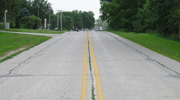
In this picture, facing west, you can see the original concrete in the middle of the road, with a slightly different shade of gray on either side. That comes from shaving down the “Iowa curbs” and widening the road. Most (but not all) of the shortcut curve from northeastbound 30 to southbound old US 59 exists, as does some of the north-south concrete, now dead-ending at a house.
Is today’s Lincoln Way not signed on Boyer Valley Road because of a desire not to put more traffic on a road that goes between railroad tracks and then intersects a heavily-traveled route where left turns would be involved? Or is it because in at least one iteration, the south route was the Lincoln? More research will be required.
(Oh, and despite the few streets in Arion for the Lincoln to follow, there may be multiple permutations there too.)