
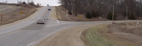
November 22, 2006: This intersection, where the Lincoln Highway turns southeast, will be removed under the preliminary plan for a US 30 expressway.
I was unable to make Thursday’s meeting — having a quarter-inch of ice covering the car will do that — but things related to it have been published online promptly. Two PDFs and a short presentation are on the PIM site.
The entire existing route of US 30, which runs on a section line, would be obliterated in favor of a new four-lane running a short distance to the north, about the width of a regular interstate median. The road won’t be a pure straight line, but very slightly wavering. As you may imagine, all the houses on the north side of the road will have to be removed. The plan does not include a bridge over the former railroad at the extinct village of Gladstone, instead leveling the land.
Current intersections with gravel roads would be maintained but the E66 intersection would not. Instead, R Avenue, a mile to the east, would be the (paved) connecting road and E66 between current 30 and R Avenue would be a mile-long dead end.
The expressway would come back to the current road west of IA 21, where there is a slight bend in the road for a bridge. That’s where this work area stops.
This is merely the environmental assessment part of the project. There is no funding set aside to do any of this. The Benton County portion is scheduled to be graded in 2016 and paved in 2018.
EDIT: I forgot to publish this post! That’s rectified now.