
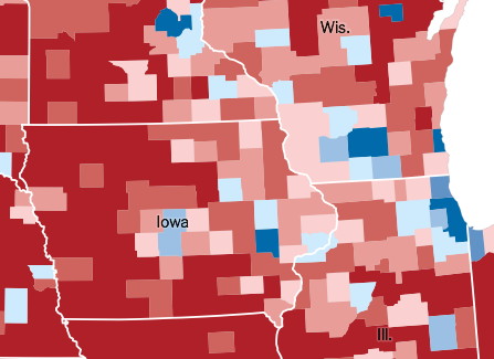
New York Times visualization of the 2016 presidential vote by county. Note that the Driftless Area (NE IA, SW WI, SE MN) tilted Republican, and while not strongly so, it’s in deep, stark contrast to the 2008 map.
First, go read this. I’ll wait. It’s important to understanding the earthquake with an epicenter of rural America that just shook the world. There’s also a Wall Street Journal article about Sac County, if you can get to it.
Now, recall this blog post I made nearly two years ago about the geographic composition of the Iowa Legislature. I noted how the Democrats dominate urban Iowa, the Republicans rule in rural areas, and the most flippable districts in the Iowa Senate would be the handful that are rural and/or had a small city.
Of the six districts that flipped Republican on Election Day, five matched that pattern to some extent.
- Mary Jo Wilhelm, the most rural Democrat in the Senate, didn’t just lose her northern district, she got creamed. Brian Schoenjahn, in a district with parts of four counties whose largest city was Waverly, also lost. Wilhelm held the largest Democratic Senate district by area. That distinction now passes to Tod Bowman, whose seat was not in this cycle but, as I said in January 2015, has/had the second-smallest population center (Maquoketa).
- The district that paired Marshalltown with the rest of Marshall County and Tama County*, and the district that paired Burlington with the rest of Des Moines, Louisa, and rural Muscatine counties, both flipped. In the district next door to the latter, mostly consisting of Lee and Henry counties, the Democrat barely survived. All have a strong blue-collar component.
- Muscatine is paired with the area surrounding Davenport on the north and west, including Eldridge and Blue Grass. Here, it could be suburban(ish) voters who changed the balance.
- The outlier is the story that by itself should have shaken up Iowa politics: Majority Leader Mike Gronstal lost the only seat Senate Democrats had west of I-35.
In January, Senate Democrats will hold all or part of 20 counties plus the towns of Cumming and Wilton. That’s it. Eighty-four percent of Iowa’s land area — about 60% of the population — will be served by a Republican state senator (or David Johnson, whose disavowal of the party over Donald Trump will … you know, I’m not even going to try finishing this thought).
On the House side, only two seats changed hands, but their location is telling: Districts 56 and 57, Clayton/Allamakee counties and all of Dubuque County outside of Dubuque. Both are in the heart of the Driftless Area, roughly defined in Iowa northeast of a line from Chester to Anamosa to Clinton (the Maquoketa River watershed and those to the north but not the Wapsi). In 2012, the mostly rural area went for Obama and caught some attention as a political anomaly (the Daily Beast wrote about the Wisconsin side two weeks ago in less-flattering terms). In 2016, the flip of those northeast Iowa House and Senate districts, taken with what happened in southwestern Wisconsin, dealt a big blow to the “Driftless Area Democrats”, but its long-term significance or permanence is unknown for now.
* Until Tuesday, Tama County had not voted for the Republican presidential candidate since 1984. Only six counties in Iowa — the five most populous and Story — went Hillary Clinton’s way. That is absolutely astounding.