
When I started my Big South Trip October 18, 2016, I didn’t have plans in mind beyond that. The following 12 months — to the day — would have me hitting the road far beyond Iowa multiple times.
By the time I landed in Cedar Rapids Oct. 17, 2017, the state-level map of my year’s worth of visits looked like this:
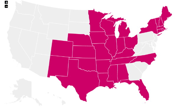
Is there some fudging in there? Yes (including double-dipping late 2016 in a “year” roundup), but it’s all technically correct!
- Pensacola is part of Florida, even if it feels like Alabama.
- Thirty feet south of the New Mexico/Oklahoma/Texas corner is still Texas.
- I was about as far from the Upper Peninsula as I could be and still be in Michigan, at the tri-state corner (and I was in the very western/northern parts of the UP in 2013 along with the very southeast corner of Michigan later that year).
- And I changed planes in North Carolina.
The nearest states I didn’t touch in that period were South Dakota (hit the edge of Sioux Falls in 2015), North Dakota (2007), Wyoming (2016), and West Virginia (10 hours away!).
In fall 2016, I added counties in 7 states; in 2017, I added counties in 20 (Indiana both years). When Kyle Munson interviewed me this February about my travels, I was 101 counties short of half in the entire country; I am now 19 away from that mark. I hit my remaining counties in Connecticut and Rhode Island and every county in Massachusetts that doesn’t require having a boat or marrying a Kennedy. Folding in my Nebraska-Wyoming trip from August 2016, I visited 160 new counties in a year and a half, the nearest of which was 270 miles away and the farthest of which borders New Brunswick.
If you took all those trips, where are the pictures? Excellent question! They’re all on my hard drive. I am bad at keeping up to date on trip reports. Because of that, I made a single page with one photo from every state I visited to bring a flavor of the places.