
“The Eagle Has Landed.” Forty-five years ago to the minute.
Related, from 2009: ISU alumnus was honored for role in Apollo 11
“The Eagle Has Landed.” Forty-five years ago to the minute.
Related, from 2009: ISU alumnus was honored for role in Apollo 11
On July 19, 1989, one of the nation’s worst aviation disasters — and one of the best under-the-circumstances success stories of heroism and emergency response — happened in Sioux City. The Argus Leader and AP have stories on the anniversary and remembrance of United Flight 232.
National Geographic created a “Seconds from Disaster” episode about the crash. It’s 46 minutes long with survivor interviews and re-creates events leading up to it (although not quite late-’80s accurate).
This introduction from an interview with Capt. Al Haynes reinforces the crew’s actions against all odds:
That’s when a 12″ pie-shaped section of fanblade cut all three independent hydraulic systems on a DC-10 with 296 souls on board. They don’t cover that in recurrent simulator training because it’s mathematically impossible. After it happened, the NTSB replicated the data of Flight 232 and not one of the 57 crews they tested in the simulator could control the airplane all the way to the ground.
Two years after the crash, Haynes said: “Enough redundancy was built into the system to where the odds were placed at 1 to 10^9th power, or a billion to 1, that complete hydraulic failure would occur. … On July 19th, Murphy’s Law caught up with us, and we did lose all three systems.” (The link goes to a long transcript of a presentation in California.)
For the first time in decades, Tama County has (sort of) paved a new rural road.
County Road T69, L Avenue, runs north-south just west of Dinsdale. It comes south from IA 175 as paved, but that stopped at the Grundy/Tama county line. When Tama County undertook a comprehensive rebuilding of D65 last year, the old asphalt from that was recycled into a bituminous/”blacktop” covering for T69.
By and large, rural Iowa roads are either paved with center- and edge-line markings or they are gravel. This is different from other states, where a middle style of not-gravel-but-not-painted blacktopping is plentiful. The new T69, though, is in this middle style, as is the former IA 362 in far western Iowa.
The county road/farm-to-market designation continues south on L Avenue, Ridge Road, and K Avenue to US 63, but there are no plans to change anything there.
(I am a little late to the party on this, but for a rural county this is a notable thing.)
The official route announcement in January was for the Register’s Annual Great Bicycle Ride Across Iowa to stop in “Okoboji,” but the maps only show the route following A34 through Milford. It was the Iowa Great Lakes area as a whole that got the stop.
Now with less than a week to go, we know more details from the overnight website. Campers will be spread out at four different locations, including the town of Okoboji proper and up at Spirit Lake school. Campers in Milford will leave on A34, while those to the north will use US 71 and 240th Avenue out of Arnolds Park.
Entering this year, Spirit Lake was the sixth-largest Iowa city and largest non-suburb* that RAGBRAI had never been to. That second distinction now passes to Kalona, pop. 2363.
*This is intended as a short-hand and not a slight to Bettendorf, which has been passed by Urbandale as the largest unvisited city overall. RAGBRAI has never officially ended in Bettendorf, which I was surprised to see when I charted everything.
A curious item in this month’s Iowa Transportation Commission minutes:
Transfer of Jurisdiction – 219th Lane in Boone County
Most of US 30 through Boone County has the rural address of 220th Street. The only 219th Lane I see on the map is a short road in the northwest quadrant of the US 30/IA 17 interchange.
The Boone News-Republican has a story from March 12 saying the road, which serves a few businesses, was going to be paved. It also says it “was a state-owned frontage road running parallel to U.S. Highway 30.”
That’s very interesting. The state of Iowa generally doesn’t own frontage roads, at least to my knowledge. This stub never received a number and was never on any map.
Last week, the Iowa City school board determined names for buildings soon to be built, including a high school on the east side of North Liberty. That one will be called Liberty High School. But why not “North Liberty High”? It’s both geographic for its position in the Iowa City district and easy correlation with the city of North Liberty.
Sure, some students with a home address of Iowa City will be going there, but plenty of students with home addresses of Des Moines suburbs go to Waukee. The other analogue I can think of is the Columbus school district with both Columbus Junction and Columbus City.
This will be the third high school in the Iowa City district, and the second division of an urban district in Iowa in the 2010s. The name will give the now-30th-largest city in Iowa a little piece of modern school history.
When Bryan Farr went across the county on US 20, he was interviewed by many media outlets along the way. Here are some late plugs from his westbound leg by the Rapid City Journal (catching him in Chadron) and the Douglas Budget in Wyoming. He has since made it back to Boston.
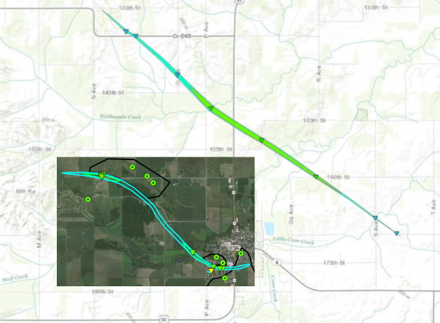
I know it doesn’t look great, but the NWS used two mapping services and I had to play with sizing. The slightly darker black line running north-south and then along the bottom left of the map is US 63. The blue bounds mark each tornado’s path with EF0-scale winds. The light green is for EF1 damage. The EF2 damage area in the southwest corner of Traer cannot be seen on this scale, only by the yellow triangle. The July 6 tornado was much longer, but left much less damage.
Bottom line, two tornadoes spawned within miles of each other a week apart, and Traer has a big item for the 2023 sesquicentennial book.
Report for June 30 (HTML with animated GIFs and Google Map)
Report for July 6 Grundy and Tama counties (PDF)
Full notification due after my earlier post. Tama County received both the disaster emergency and Iowa Individual Assistance Program qualification. Benton County only received the former.
The news of a potential split in the 19-team Central Iowa Metro League* bears some similarities to what went on in college sports the past half-decade. This time, though, it’s the have-nots taking the initiative and separating from the haves.
The splitters are a pretty obvious group: Five Des Moines high schools that are not evenly distributed in student numbers; Ottumwa, which was lumped in with the Des Moines schools** in the football “Metro Conference” until Class 4A was reorganized into districts last year; Marshalltown, which has an easy driving connection to Des Moines and a football team that had a spurt of success in 2009-12; and Indianola, the second-smallest school in the CIML.
Feeding into the parallel with college football-driven realignment, these schools aren’t as flashy in the facilities arms race and don’t get as much respect media market-wise (ValleyDowling ValleyDowling BattleOfAnkeny ValleyDowling). They also are the ones with the population problem; the Register noted Marshalltown and Ottumwa have had double-digit enrollment drops in the past decade. The suburbs, meanwhile, continue going like gangbusters.
We are talking about the separation of the top of the top; Indianola still has more students in grades 9-11 alone than 60% of Iowa’s districts have total. I’m a small-school fan, of course, but shakeups at the top are something to keep an eye on.
*How does a 19-team conference manage a decent basketball season, anyway? Or do all teams not play each other?
**In retrospect, that’s really why IA 163 needed to be four-laned.