
Starting last Monday, US 63 is completely closed through Hudson, using D46-IA 21-US 20 around the town. (IA 58 will be sent along D35 to meet 63.)
This is the information I was looking for before the DOT’s website change got me ranting.
Starting last Monday, US 63 is completely closed through Hudson, using D46-IA 21-US 20 around the town. (IA 58 will be sent along D35 to meet 63.)
This is the information I was looking for before the DOT’s website change got me ranting.
I swear, I go away for a week and everything goes sideways.
I knew something was up when my iBook rendered the main page as nothing but a gray background. It had been just fine. But later, checking the website on a more recent computer, I found the reason: The whole front-end is a dynamic scripted-up-the-ying-yang cluster of bells and whistles. The only clue this was going to happen is a March press release about a survey, and also possibly this July 11 notice about a mobile app.
I want a page full of links, not a one-panel tablet-optimized-so-keep-clicking window that is mostly a background image.
Yeah, yeah. Oldthinker unbellyfeels Web 2.0 and all that. But if I’m frustrated with the layout, less Web-savvy users may be too.
The press release page itself remains unchanged, so far. (Of course, that’s the one that needed work.) Clicking through from the main page, though, gives you only the two most recent.
Please tell me this isn’t serious. Please tell me this isn’t serious. Please tell me…

*facepalm*
Oh bother.
(Composite image via SBNation)
EDIT: Speaking of logos, USA Today…

Screenshot taken 2:10 PM. (Larger in new tab.)
Here’s something to start getting back in the swing of things.
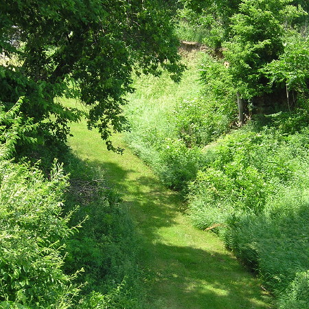
June 22, 2013
This is what’s left of the Honey Creek Cut, in public view anyway. At the time, it was much deeper and considered a notable work of engineering. However, the cut was bypassed by the end of the 1920s. You can see a bit of the loess soil near the top center of the picture.
The remnants of the cut can be reached via the recently opened Hitchcock Nature Area RV campground. To the northwest, plainly visible from the air but not accessible, are two telegraph/telephone poles.
With that, I’ve shown a little something of or about the Lincoln Highway in every county the route goes through. I took hundreds of pictures over the course of 3½ days, capturing as many aspects as I could of the historic road at its centennial. It would be nice to compile them, along with others, into a book, but I’d need some help doing that. (If you can offer advice, let me know.)
Don’t expect a Nebraska picture tomorrow. This blog will be on hiatus for a little bit.
Why do the highway lines on Google Maps now look more like Yahoo?
Why are pre-2003 and even pre-1980 highway designations showing up everywhere?
Why are there IA 57 markers running along the Butler-Grundy county line? Why are various other now-decommissioned highways going where they never did?
Why, if certain lesser roads are supposed to be a different width, do some of them change abruptly regardless of pavement?
Why/What is this giant gray blob southwest of Oelwein?
Why are there still no county road names in the entire state of Iowa?
And if all of this is supposed to be for Android, why are cleanliness and accuracy being sacrificed for features? (And why can’t the writer of the linked article use to/too/two correctly? Or see the error in the phrase “as a free downloads”?)
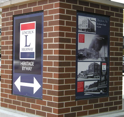
July 5, 2013: In downtown Carroll, the city erected special Lincoln Highway pillars at intersections between 3rd Street and the courthouse. One has a time capsule.
This week it was NBC’s turn in the HOW DO I GEOGRAPHY Hall of Shame, mislabeling a map related to the train crash in Quebec. It spent part of Tuesday night apologizing to the Granite State.
The Concord Monitor has the videos; Boston Magazine has some comments; the Clinton (Iowa) Herald has another news story.
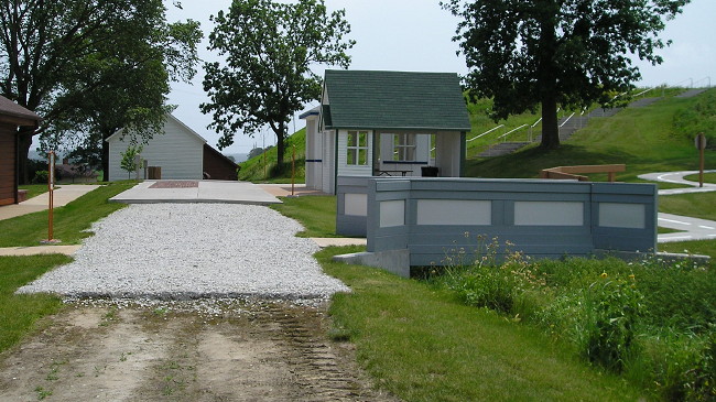
June 22, 2013
The Iowa Welcome Center/Lincoln Highway Interpretive Center northeast of Missouri Valley is a definite stop for any traveler. A film inside the welcome center, as well as the displays and representations of the early days of highway travel, are all worth seeing.
The picture above shows the evolution of surfacing, laid right on an old grade of the Lincoln Highway (a part of Monroe Avenue used to curve right instead of left as part of the route). You can walk from dirt to gravel to brick/concrete to asphalt. On the side are scaled-down replicas of a bridge, tourist cabin, and gas station typical of the era. The bridge leads to a kids’ play area on winding roads complete with a set of Burma-Shave signs.
Much of the signed Lincoln Highway between Missouri Valley and Dunlap is gravel, moved west and diagonalized in later stages. It’s narrow and not always straight, either, a contrast even to the 10 miles of gravel between Westside and Carroll.
Hold on, because this may get confusing, and I haven’t had time to make maps yet.
The presumed route of the Lincoln Highway heading out of Denison from the present north US 30/59 intersection was southwest on later-abandoned concrete around a motel, Boyer Valley Road between two sets of railroad tracks, and then (of course) gravel Lincoln Way away from the railroad and then back paralleling the railroad into Arion.
Well, in the 21st century signage of the route, a substantial part of the Lincoln Highway isn’t on Lincoln Way at all. Instead, from the north 30/59 intersection, the route follows present-day 30 southwest to Q Avenue, then crosses the railroad tracks, then heads southwest on gravel.
To further complicate the issue, the 1912 Trans-Continental Route guide has the road entering Denison from the south side, south of the tracks, using now-abandoned roads between US 59 and Main Street, and a 1920 Crawford County plat book doesn’t show a road in the present-day Boyer Valley Road place at all.
What I do know is that US 30 was paved through Crawford County in 1929. By no later than the late 1930s, from 4th Avenue and 7th Street, the concrete followed an arching path across the Boyer River (concrete that would remain until the 1990s), intersect Boyer Valley Road at a Y intersection, cross the Chicago and Northwestern (now Union Pacific) double tracks on an overpass, and then have another Y intersection with the road going south to Harlan.
From the south Y, US 30 then went southwest, and that road exists today as Chamberlin Drive.
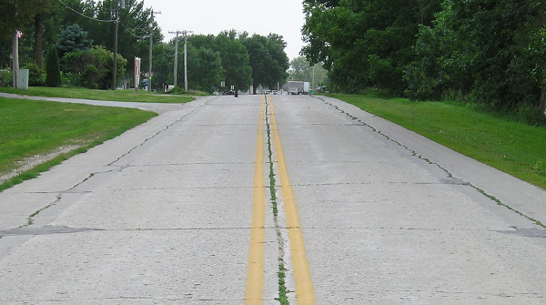 June 22, 2013
In this picture, facing west, you can see the original concrete in the middle of the road, with a slightly different shade of gray on either side. That comes from shaving down the “Iowa curbs” and widening the road. Most (but not all) of the shortcut curve from northeastbound 30 to southbound old US 59 exists, as does some of the north-south concrete, now dead-ending at a house.
Is today’s Lincoln Way not signed on Boyer Valley Road because of a desire not to put more traffic on a road that goes between railroad tracks and then intersects a heavily-traveled route where left turns would be involved? Or is it because in at least one iteration, the south route was the Lincoln? More research will be required.
(Oh, and despite the few streets in Arion for the Lincoln to follow, there may be multiple permutations there too.)