Mar 18

Viking Road SPUI construction restarting

According from a press release from the DOT, this week is when construction will resume on IA 58 at Viking Road. The two-year project to run the highway under grade and form a single-point urban interchange is expected to end around this Thanksgiving.

A rendering of the completed interchange (PDF) is on the first page of this newsletter from the city of Cedar Falls last year.

Posted in Construction | Comments Off on Viking Road SPUI construction restarting
Mar 15

The road to Backbone State Park

OLYMPUS DIGITAL CAMERA
July 29, 2017: The Iowa Civilian Conservation Corps Museum in Backbone State Park shows off the contributions the New Deal program made to Iowa’s state parks and natural resources. Backbone, Iowa’s first state park, celebrates its centennial next year.

At the end of 1926, Iowa had a network of newly signed highways. The brand new federal system linked the state from coast to coast and from the Dominion of Canada to New Orleans and the Gulf of Mexico (at the expense of the auto trails, which would dry up in the next five years).

The October 1926 renumbering included the introduction of the round shield with “IOWA” at the top. Ducking just under the wire for inclusion were #152 (a spur to Murray, signed at the same time US 34 was signed south of town), #153 (Wyoming to Oxford Junction), and #154 (the road that was superseded by IA 187 at the end of 1980).

In the remaining three years of the decade, nine new routes would be assigned, while additions to the system and construction changed the routing of others. The first true addition has a little bit of mystery at the beginning and a large mystery at the end.

On May 3, 1927, the Iowa Highway Commission added a road to the north entrance of Backbone State Park to the primary system. At the time, a month could pass between approval of a road in the system and assigning it a number, and another month or more before it was signed in the field, and still more time if construction was involved.

This tiny road was given a number that, months earlier, had run the length of the state: IA 19. Why 19? This ties in to my previous post: The westernmost extension of US 18 came after all the highway signs were put up in October. That meant that not only was #19 newly available, but the #19 shields could be shipped across the state for use. IA 19 had to be designated before September 20, 1927, when a memo explicitly said #104 was the only unused number, save for #24 which had been replaced by #2 a month earlier and had lots of signs.

The November 15, 1927 meeting of the Clayton County Board of Supervisors mentioned a minor change in IA 13 southeast of Strawberry Point. The change took the road off what today is East Mission Road running east out of Strawberry Point and put it on the modern alignment of IA 3/13, including the intersection of the road to Backbone, marked as IA 19 on the 1928 map.

That would have been the end of the story…but there’s one more thing.

In 1957, when the Highway Commission started reassigning numbers to get out of the way of the new interstate system, IA 19 was redesignated IA 410. There was no reason for this to happen. The online route description mentions a letter that, if it was on the microfilm, I missed despite going through the whole roll twice. The small number on a small road was replaced with a large number on a small road, and there it stayed until the Second Great Decommissioning.

The online addition of route descriptions answered the question about another spontaneous renumbering of a road to a state park: IA 162 became IA 322 because “two to three trucks per week” mistook the turn for US 169 half a mile away. Were drivers mistaking the beginning of IA 19 for the turn of IA 13? For now at least, the issue remains a mystery.

(Sources: Highway Commission microfilm viewed more than a dozen years ago and online Clayton County Register archives viewed more than a dozen days ago.)

Posted in Highway Miscellaneous | Comments Off on The road to Backbone State Park
Mar 14

The west end of US 18 that officially wasn’t


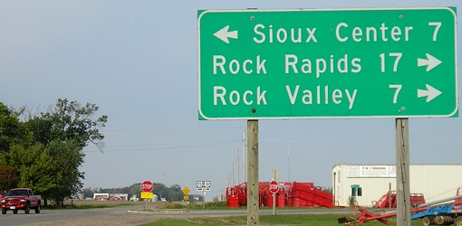
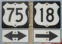
September 17, 2007: Westbound US 18 at US 75 in Sioux County. There are some ag-related businesses here, half a mile east of the unincorporated village of Perkins (which consists of a few houses and a salvage yard).

I have wondered if it would ever be possible to track down the status of US 18 in the fall of 1926, given the many documents that showed the highway was scheduled to end at US 75 but by every 1927 map had it already continuing into South Dakota.

As late as Oct. 4, 1926, the Iowa Highway Commission declined to join the South Dakota Highway Commission in requesting that US 18 be extended west to US 85. That was coming right up against the installation of the route markers in Iowa, which began about a week later and was completed Oct. 16 (as Jason Hancock learned a long time ago). This was on the early end of signing across the country, working off plans that had been two years in the works.

Now, thanks to a short front-page article in the Sioux County Index of Hull*, I have the best confirmation we’re likely to get that US 18 was SIGNED to end at US 75 for a brief period in late 1926. According to the story, the extension was approved at the AASHO meeting of November 11, 1926, which is considered to be the official birth of the federal highway system.

Black Hills Highway
O.H. Hetli, State Engineer, of South Dakota, was present at a government meeting of State Highway Engineers in Pinehurst, North Carolina, on Monday. In the interests of the Black Hills Hiway, Mr. Hetli asked that Federal Highway No. 18 be extended from Perkins Corner, west through Inwood over the Custer Battlefield Hiway, across South Dakota over the C.B.H. into Wyoming to the point where it intersects with U.S. No. 85, which then takes it into Denver.
— Sioux County Index
, Nov. 26, 1926

US 18 would have been signed into South Dakota by the end of the year, since 1927 maps and the Highway Commission’s service bulletin all say so. To make a comparison that no one would have understood 90 years ago, Iowa’s October signage was based on a software “late beta” before the release of Version 1.0.

So, for a few short weeks at the end of 1926, the equivalent of the assembly shown here read “End 18.” After that was changed, for about three years, 18 and 75 went a mile north, then three miles west, heading north on K42 toward Doon. Then they split and 18 went west on A42 to Inwood and 75 angled northeast toward Rock Rapids.

Ironically, through all the early preparation and fine-tuning of the system on both the state and national levels, it appears no one ever looked at the maps and said, “Hey, wait a minute. US 218 is based on an even number and is going north-south. What’s up with that? Why isn’t it US 265?”

*via Advantage Preservation, whose OCR-based microfilm scanning is THE GREATEST THING SINCE TABBED BROWSING.
Posted in Highway Miscellaneous, Maps | Comments Off on The west end of US 18 that officially wasn’t
Mar 13

Significant part of country already ‘ahead of time’


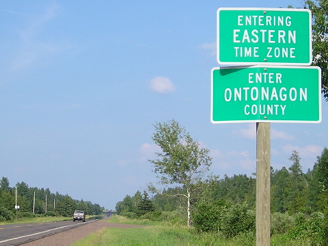
July 15, 2013: The westernmost highway entry into the Eastern Time Zone, MI 28 in the Upper Peninsula, is farther west than a lot of Illinois. Longitudinally, it’s roughly on par with Sterling, less than 30 miles from Clinton. It’s a good deal farther north, of course, but does this really look like 5:30 to you?

Once again, but this time with some additional politicians on board, they want to mangle clocks in the United States even more.

It is bad enough to have Daylight Saving Time spread across March and cover Halloween (now much of trick-or-treating is done in dusk or even daylight hours). It would be much worse to run it all year.

Sunrises would be exceptionally late in Iowa during winter under permanent DST — an entire month after 8:30, according to KCRG. Any state above 40° North latitude should oppose the idea. But there’s another argument against such a move: Significant portions of the country are in time zones that do not match their geography.

If time zone lines hewed closer to where they should, in 15-degree longitudinal increments with the “solar noon” in the middle, the contiguous United States would have dividing lines at 82.5° W, 97.5° W, and 112.5° W. Instead, they are up to hundreds of miles west.

This pair of tweets shows when “solar noon” happens across North America with and without DST. All the parts that are in orange are, quite honestly, in the wrong time zones. That includes huge swaths of Texas and the Great Plains, a good chunk of Idaho, the eastern part of the Florida Panhandle, eastern Kentucky and Tennessee, half of Ohio, and all of Indiana and Michigan.

DST puts solar noon more than an hour and a half behind clock noon in some places; permanent DST would make that a year-round problem. Florida’s House tried to make it even worse with a bill that would have put the rest of the Panhandle in Eastern Time.

(You know who would really be screwed with permanent DST? Canada.)

The change that is needed is not permanent DST. It’s smart DST, which would mean restoring pre-2007 (at least) calendar changes — something more difficult to regulate with a couple zillion more computers in Americans’ pockets and purses than there were then — and realigning time zone boundaries to better match the sun. Yes, I’m still in favor of changing the clocks.

At the very least, the Louisville area, Indiana, and much of Michigan’s Upper Peninsula (if not all of Michigan) need to be wrenched into God’s Own Time Zone where they belong. Move the lines all the way over up and down the country and maybe we can get broadcasters to acknowledge that a world exists outside of Eastern Time.

Posted in Geography, Maps | Comments Off on Significant part of country already ‘ahead of time’
Mar 12

Hancock photos sprinkled across pages

I raided Jason Hancock’s Flickr galleries (with his permission) to see if there were any gems that could augment these pages. They were taken at various points in the past decade, but they’re new here.

At least one new photo, although usually only one photo, has been added to: US 34, US 136, Business 61 Davenport (IA 461), 25, 32, 44, 83, 90, 105, 192. More photos were added to the Iowa side of I-129 as well.

Jason also had good coverage of the I-380/IA 100 volleyball interchange, which is a tricky one to do for a single driver, showing the replacement of Cedar Rapids with Iowa City on the BGSs. I used that opportunity to rewrite the text for IA 100 to reflect its completion to US 30.

Posted in Highway Miscellaneous | Comments Off on Hancock photos sprinkled across pages
Mar 11

License Plate Letters — HUG

OLYMPUS DIGITAL CAMERA
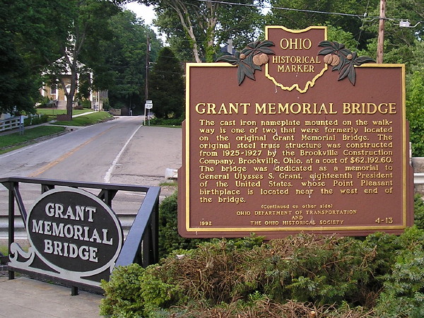
July 7, 2008: The US 52 bridge in Point Pleasant, Ohio, is the Grant Memorial Bridge, named for its most famous son. US 52 hugs the north bank of the Ohio River from Cincinnati to Huntington. Grant also lived in Galena, Illinois.

After not noticing new sequences for a while, I saw a spate of them in the past week or so. We’re almost through the H’s in Iowa.

But what does this have to do with the 18th president? Well, Ulysses S. Grant is not his birth name. He was born Hiram Ulysses Grant. I had read he didn’t like the initials HUG, but now I see sources that say the name change relates to Grant’s congressman misstating his name in the application to West Point.

Last year an annotated version of Grant’s memoirs was published to high acclaim.

Posted in License Plates | Comments Off on License Plate Letters — HUG
Mar 08

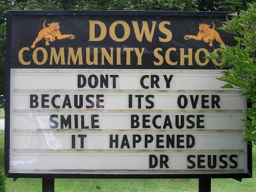
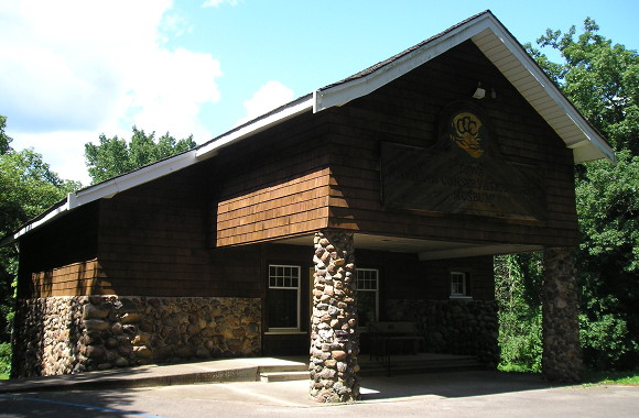
Four, count ’em four, visits to Dows


September 11, 2014: Eight years after starting its partnership with CAL, Dows started sending students to Clarion-Goldfield, one of the few times a school switched sharing arrangements before eventual consolidation.

(TLDR: I added a bunch of photos to the IA 72 page, including a bunch from July 2011 that I edited in August 2012.)

I have been to Dows four times for Iowa Highway Ends.

The first time, 2003, was on the way to a North Tama football game at Sheffield. It was after class on the Friday of Labor Day weekend, but hitting both Randall and Dows to get photos for IA 383 and IA 72 added a couple blocks to my growing website and I discovered a unique case of a highway whose east end faced west.

The second, in 2011, was a minor detour after a hotel stay in Lake Mills (with themed rooms) and a day that was mostly occupied with the Surf Ballroom and Music Man Square.

I swung by for the school in 2014 after the news that the Dows school district would merge with Clarion-Goldfield and its century-old building would close. That trip was to tackle a batch of tiny towns primarily in the north half of Humboldt County.

And then, in one of my few trips last year, I looked up what I could use better or updated photos of in north-central Iowa and traveled the old route of IA 72 from US 69 to I-35 one more time. (Still think Wright County’s motto can be “I can see for miles and miles and miles…”)

I think I’ve covered just about every angle, but who knows. If there are other places I’ve been to that many times specifically for trips, I might post about those too.

UPDATE 5/24: Clarified caption. Also, Marathon is a four-timer.

Posted in Iowa Miscellaneous | Comments Off on Four, count ’em four, visits to Dows
Mar 06

Springville interchange proposal moves forward

Security State Bank probably thought it had a swell deal with a high-visibility spot on four-lane US 151 at the new main entrance to Springville. A building opened in the northwest corner of the intersection with County Road X20 in 2005.

But with the completion of the four-lane to Dubuque, traffic on 151 increased substantially. For more than a decade, the intersection has been on the state’s list of most dangerous. A KCRG story from 2017 about one of the crashes said there had been 34 in seven years.

Nearly a decade ago, the DOT wanted to set up a J-turn — you may remember this term from when it was a possibility at the IA 330/US 65 intersection, and again when it was a possibility at the US 30/218 intersection. Indiana just started using it; it’s a close cousin of the “Michigan Left” except that a J-turn allows left turns from the dominant road. But it means that traffic from the intersecting road has to turn right, cut through two lanes of traffic moving at high speeds, and then merge from the left into other traffic moving at high speed. The technique has not appeared in Iowa yet, and every time it’s proposed it’s met with strong opposition.

Now, eight years after the state presented 16 alternatives for the 151/X20 intersection at Springville, the state … has completed the environmental assessment on an interchange. Three of the dismissed alternatives use a “parclo” setup which involves a loop ramp for northbound X20 to southbound (westbound) 151. But the DOT’s preferred option is a diamond interchange with that ramp going right through the existing Security State Bank building. The Casey’s next door would remain intact (or so I interpret).

There will be a meeting about the interchange, with a formal presentation, on March 12 at St. Isidore Catholic Church, which is right by the intersection.

The Springville intersection is likely the most important one between Marion and Dubuque that didn’t get grade-separation, because that part of 151 was four-laned earlier. But the situation there isn’t tenable anymore, and an interchange needs to happen.

Posted in Construction | Comments Off on Springville interchange proposal moves forward
Mar 05

Dateline Buckingham

!!!

Politico: A native Californian learns that Iowa is as nice as it’s cracked up to be.

BUCKINGHAM, Iowa — Janet and Mike Shock reclined in loungers while trying to write the first sentence of this story.

Janet offered a literal interpretation of my misfortune: “Stranded in Buckingham, Iowa,” she said.

…

He went to school in nearby Traer, where it’s customary to have cheese sandwiches with the meal. But she, a product of Waterloo schools, keeps to a tradition of peanut butter, hence the jar of JIF next to our butter and biscuits. We also talked about their family, and they FaceTimed with my wife and baby.

Just when I was about to swap out my “I ♥ Iowa” header. It can stay another week.

Posted in Tama County | Comments Off on Dateline Buckingham
Mar 04

Private schools dominate 1A basketball field

For the second time this century, more than half of the teams in a Class 1A state tournament will be private schools.

The bracket for the boys’ basketball tournament starting today has Algona Garrigan, Grand View Christian, Council Bluffs St. Albert, Clinton Prince of Peace, and Remsen St. Mary’s in the final eight, a much higher proportion than the approximately 15% of Class 1A competitors that are private. It’s been 25 years since Clinton’s school made it to state, but Grand View Christian is the defending champion.

The five-private-school total ties the 2008 Class 1A state baseball tournament, although Don Bosco lost to undefeated Lisbon that year. The tilt in Class 1A baseball has been around a while — public vs. private in the championship game almost every year for more than a quarter-century — but as recently as 2015 no private schools made it to the Class 1A boys’ basketball tournament.

Posted in Sports | Comments Off on Private schools dominate 1A basketball field