Jan 18

CAL losing junior high, high school

The Coulter-Alexander-Latimer school district, hammered by the population decline affecting nearly all of rural Iowa and the end of a sharing agreement with Dows a decade ago, is unable to hold on to its independence.

CAL will send grades 7-12 to Hampton-Dumont in fall 2018, the Mason City Globe-Gazette reports. That means there will be a full year and a half of “lasts” ahead — except the last football homecoming, because CAL already couldn’t field a football team and made an agreement with Clarion-Goldfield-Dows for 2016-17.

If not for the significant part of H-D in Butler County (Dumont and Aredale), “Central Franklin” would be a good school name, but since this is a one-way sharing agreement the current status of H-D is unlikely to change.

Posted in Schools | Comments Off on CAL losing junior high, high school
Jan 17

One contractor, two sign color problems


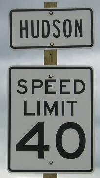
July 2, 2014: City limit sign for Hudson just north of IA 58’s rebuilt south end. Black-on-white and all-caps are both non-standard.

When IA 86 opened from IA 9 to the Minnesota border in November 2013, the “Dickinson County” sign was not only the old small style, but it was black text over a white background. It was fixed in a month.

When the reconstructed US 63 opened from the south side of Hudson to US 20 in summer 2013, more signs were the wrong color. The one seen above is still there.

As it turns out, both the IA 86 project and US 63 project had Cedar Valley Corp. as the primary contractor. If the contractor was in charge of the signs (and the letting contract for 63 did have signage pages), that could explain why two distant locations had identical issues.

Posted in Highway Miscellaneous | Comments Off on One contractor, two sign color problems
Jan 16

How do you ‘rebrand’ a corner?

The federal government gave the final approval last week to redo the I-35/80 interchange with IA 141 and add ramps at Meredith Drive, the Des Moines Register reports. Here’s the nugget that makes it weird:

The interchange is located at the junction of Urbandale, Johnston and Grimes. It’s known locally as Rider Corner for the 90 degree turn the interstate makes and for the Rider Coal Mine that once operated nearby. Johnson said re-branding will be a part of the project.

Why does the corner need to be “rebranded”? Is it because there was nothing out there until 25 years ago, or because a suburb can’t be associated with something as unfashionable as a coal mine? The name is on old USGS topo maps, so it’s not necessarily gone from memory. Is the city of Urbandale going to sell naming rights (“Rider Corner Presented by SuperTarget”)?

Posted in Construction | Comments Off on How do you ‘rebrand’ a corner?
Jan 13

Pilot Knob is not Iowa’s second-highest point. Or the third.


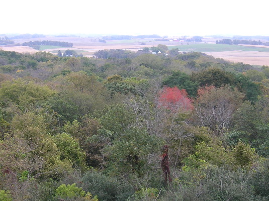
October 4, 2016: The view from the Pilot Knob observation tower, which is 30 feet tall. Enjoy it before I drop some earth-leveling news.

While working on the page for IA 237, the old spur to Ocheyedan, I had a realization. For decades, Ocheyedan Mound (elevation 1613 feet) was considered the highest point in Iowa. But when that recognition was moved to Hawkeye Point (el. 1670), it’s not like the mound disappeared.

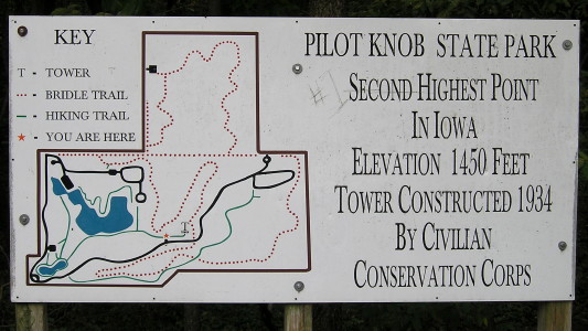
Then, last fall, after I visited Klemme and toured the Winnebago factory complex in Forest City, I stopped by Pilot Knob State Park, which will be 95 years old in 2018. Like Ocheyedan Mound, the highest point in the park is a glacial kame. But unlike the mound, it has a specific claim.
OLYMPUS DIGITAL CAMERA
October 4, 2016: Number 2 on the sign, but Number 1 in someone’s heart.

Wait a minute. Wait. Aaaaaaa. Min-ute.
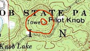
pilotknobtopo USGS topo; 1400, 1450 marked

OLYMPUS DIGITAL CAMERA
October 4, 2016: On the path to the CCC tower at Pilot Knob: Doe, a deer, a female deer.

An elevation of 1450 is a drop of more than 100 feet from the two Osceola County points. Once the highest something becomes the second-highest something, it follows that the second-highest something should become the third-highest something. But even the official Iowa DNR page still bills Pilot Knob as the second-highest point in Iowa, and that can’t be remotely true.
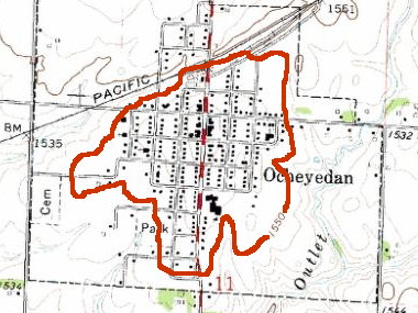
ocheyedan1550 USGS topo

The entire town of Ocheyedan is above 1550 feet — 100 feet higher than Pilot Knob. A significant percentage of Osceola County is above 1500 feet.

It doesn’t take much of a peak or rise to be a high point — at Hawkeye Point, you wouldn’t think about it if not for the newish stone slab saying so. But if you were standing in the parking lot of the now-demolished Ocheyedan school, you would be at a higher elevation than even the top of the Pilot Knob observation tower.

The reassignment of Iowa’s highest point automatically should have demoted Pilot Knob in the hierarchy, and the maps above show that it should go even lower. With the information and measuring tools we now have available, why hasn’t anyone else noticed this?

Posted in Geography, Iowa Miscellaneous | Comments Off on Pilot Knob is not Iowa’s second-highest point. Or the third.
Jan 12

Council Bluffs remakes Broadway intersection

OLYMPUS DIGITAL CAMERA
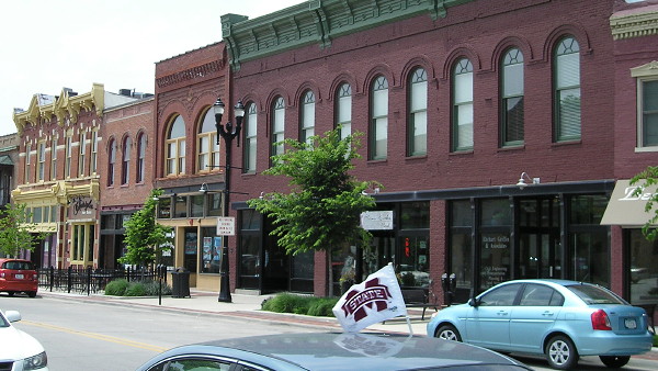
June 22, 2013: East Broadway in downtown Council Bluffs. The owner of the Mississippi State flag isn’t lost, just here for the College World Series. This photo is west of the Broadway/Kanesville intersection on the historic Lincoln Highway.

Although (as of this writing, after a call to the city) US 6 is still signed through Council Bluffs on West Broadway and Kanesville Boulevard despite an approved transfer of jurisdiction, the city is already changing the road. The Nonpareil reported last week that in a project that ended Dec. 29, the intersection of East Broadway and Kanesville was reconfigured from a Y to a T. The intersection was built in the early 1980s, when Kanesville was extended westward so US 6 could bypass downtown Council Bluffs. The Lincoln Highway gets back onto 6 here, goes northeast to the next intersection, then heads north on North Broadway. The road pattern that existed in the area when the Lincoln Highway went through and US 32/6 exited the city on McPherson is nearly buried, and this changes it further. The intersection is where IA 183 ended from 1969 to 1981 (after taking over the US 30A designation south of Missouri Valley) and a sign still pointed to the route until 2003.

The unusual part of this is that last I knew, the Iowa DOT was going to keep control of this part of Kanesville, since it’s east of downtown. Based on a photo of the new intersection, though, only a tiny portion of that road needed work, so there was probably some sort of agreement made.

Posted in Construction | Comments Off on Council Bluffs remakes Broadway intersection
Jan 11

G is for Gladbrook

IF

IF
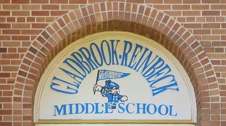
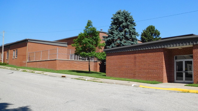
July 7, 2015: The former Gladbrook-Reinbeck Middle School was the Gladbrook High School before 1988.

The Gladbrook school is another recent addition to the list of closed schools in Iowa. This closure in 2015 triggered something that had never happened in Iowa history: Residents petitioned for the district’s dissolution. The yearlong process reached the point of a draft map being released to disperse the district among five bordering ones. But on Aug. 23, the board rejected the petition over the validity of signatures, making the previous year of meetings and efforts all for naught.

The GR school district and the city spent nearly $550,000 on a fitness center attached to the school that opened in 2008. There’s also an indoor pool, but the pool’s Twitter account has all of eight tweets in 50 days in 2014.

Posted in Schools, Sequences, Tama County | Comments Off on G is for Gladbrook
Jan 10

A look back at the Avoca courthouse

The Daily Nonpareil has a feature on when Pottawattamie County had two courthouses — but, depending on how you interpret the wording of an 1886 law, maybe not two de jure county seats. Pottawattamie is the second-largest county in Iowa (954 square miles), behind Kossuth (973), which should be two counties but isn’t because of a historical trail that involves Humboldt County being compared to Poland.*

If Pottawattamie County had been divided, Avoca would have been the Belknap County seat — a “four-by-three” like Audubon or Ida** — with the line running south from the southern part of today’s Harrison-Shelby county line. That would have left 522 square miles of Pottawattamie to the west, still larger than Belknap.

*How did a copy of “History of Kossuth County, Iowa” (1913) end up at the Stanford library?
**Ida County got cheated. Move a column of townships over and Ida gets Cushing, Danbury, and all but a corner of Correctionville, and Woodbury County would still be about the size of a “five-by-four” like Tama.
Posted in Iowa Miscellaneous, Maps | Comments Off on A look back at the Avoca courthouse
Jan 09

Three Kmarts in Iowa closing

Calvin: Dad, how do people make babies?
Calvin’s Dad: Most people just go to Sears, buy the kit, and follow the assembly instructions.
Calvin: I came from Sears??
Calvin’s Dad: No, you were a blue light special at Kmart, almost as good, and a lot cheaper.
— “Calvin and Hobbes,” April 18, 1987

I am barely old enough to remember when K-Mart (note hyphenation) was a main place to shop in the Crossroads area, even with a blue light special or two. That location closed in 2003. Now, after 25 years of Wal-Mart and about 10 of the Internet eating its lunch, the last Kmart in Waterloo is closing by the end of March. Dubuque and Sioux City are also losing their Kmarts, within 18 months of the stores in Clive, Ames, and Ottumwa closing.

Of the dozen stores that will be left in Iowa, five — Algona, Charles City, Oelwein, Red Oak, and Webster City — are in towns with fewer than 10,000 people but, more importantly, don’t have a Wal-Mart. In fact, the one in Algona is the only big-box store in a 40-mile radius.

Posted in Iowa Miscellaneous | Comments Off on Three Kmarts in Iowa closing
Jan 06

Iowa’s westernmost Casey’s moving a tad south

(It’s a slow news week, folks.)


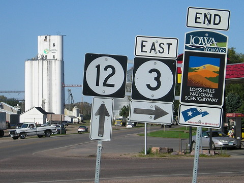
September 30, 2015: The Akron Casey’s is behind the signs for the IA 3/12 intersection and relocated end of the Loess Hills Scenic Byway.

The northwest Iowa town of Akron is getting a new Casey’s, the Le Mars Sentinel reports. This has only a thin string of relevance to this blog as it is the westernmost in the state (and yes, I have stopped there). A new gas station will be built on the southeast corner of the IA 3/12 intersection shown above. This is possible because the Iowa DOT closed the Akron maintenance shed/snowplow garage four months ago, along with Sabula (the easternmost site), Rock Valley (also in northwest Iowa), and four other locations. The DOT garage will be demolished.

Mother Nature decided to get the demolition under way a bit early by peeling off the top of one of the DOT sheds on Christmas Day, the Akron Hometowner reports.

The Sentinel article also mentions something about the convenience store chain’s history: The Casey’s style that was typical until about a decade ago dates back to the late 1970s.

Posted in Iowa Miscellaneous | Comments Off on Iowa’s westernmost Casey’s moving a tad south
Jan 05

Renwick rallies to save its bar

AP story via WCCO.

Residents of some towns are scrambling to hold on to at least a few places where people can still get together. It’s not just bars but groceries, cafes and other stores.

They don’t expect to turn around their communities’ prospects, but after watching so many businesses shuttered, they feel they had to draw the line somewhere.

Posted in Iowa Miscellaneous | Comments Off on Renwick rallies to save its bar