May 06

O is for Otranto


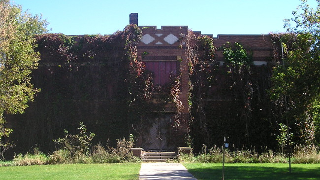
September 29, 2015: Iowa’s Prairie Castle of Otranto. The vines certainly add a gothic touch.

The school in tiny Otranto, just south of the Minnesota border, was in use for 50 years and closed in 1966, according to a reprinted article on the Mitchell County IAGenWeb site. That makes this structure a century old this year. According to a Mitchell County Press-News article from 2006 about an all-school reunion for Otranto,* the last high school class graduated in 1943 and after that it was an elementary school. Otranto rejected consolidation with St. Ansgar in 1956, which created a minor problem when some of the land planned for the new St. Ansgar Community School District was separated from the rest of the new district. Otranto held on for a while longer — “Otranto objects to loss of school under merger” is a headline in the Austin (MN) Daily Herald Feb. 27, 1962.

Also in Otranto, an 1899 truss bridge with an unusual design spanning the Cedar River, bypassed in 1999, was dismantled in March 2014 under mysterious circumstances.

*That article uses the same history text in the last paragraph as an Austin Daily Herald article from 2000 and Northwood Anchor article from 2003 about previous Otranto all-school reunions. Hmm…

Posted in Schools, Sequences | Comments Off on O is for Otranto
May 05

An IA 92 bypass of Oskaloosa?

There is a meeting next week to “discuss the conceptual alignments” of a bypass of IA 92 around Oskaloosa. The study area encompasses a wide space, since this is literally the first step in the process. Any construction likely wouldn’t happen for a decade.

Very preliminary looks at a west-side bypass of Oskaloosa for US 63 have been bandied about as well. Both plans would use the IA 163 extension built in 1997. It would be possible to remake the south interchange to accommodate all directions of traffic and IA 92 to go east and northeast from there.

UPDATE: A more detailed proposal is online now with multiple options. The 63/163 interchange would be turned into a folded diamond. A new interchange could be built either south of that interchange with a waaaay out-of-the way bypass for 92, or northwest of that interchange on a straight-then-diagonal alignment around the south and southeast sides of Oskaloosa.

Posted in Construction | Comments Off on An IA 92 bypass of Oskaloosa?
May 04

What will happen to St. Ansgar Elementary?

OLYMPUS DIGITAL CAMERA
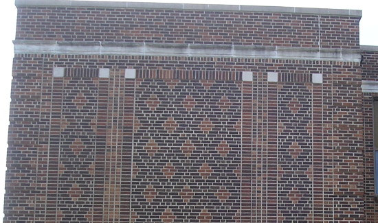
August 4, 2015: Detailed view of the brickwork at the southeast corner of the St. Ansgar Elementary building, which started out as the town’s main school building. They don’t build them like this anymore.

The St. Ansgar school district has built an elementary addition onto its high school complex along with a new gym, and the fate of the town’s 1928 school building will be determined soon. The Mason City Globe Gazette reports there are two options on the table. In one, the building will be demolished and six residences built on the land. In the other, the building would stay and become a community center.

Posted in Schools | Comments Off on What will happen to St. Ansgar Elementary?
May 03

Jefferson Highway book published

The Jefferson Highway, the much-less-known north-south counterpart to the Lincoln Highway in Iowa, is getting its time in the spotlight. There is now a book about the route, which went from Winnipeg to New Orleans (“Pine to Palm”).

In Iowa, the Jefferson — important enough to be numbered the first IA 1 in 1920 — roughly followed US 69 from the Missouri state line to Ames, US 30 between Ames and Colo, and US 65 to Minnesota. The big curve at Niland’s Cafe is because that’s the way the Jefferson went. US 65 did not run south of Colo through Collins and Bondurant to Altoona until 1940. (The book’s author says the first route of the Jefferson went through Shipley, south of Nevada, but by the time of the first Highway Commission map in 1919 the straight route through Ames had won out.)

The WHO story says the Jefferson Highway will be signed as a historic byway like the Lincoln Highway, so that will be something to check out next year.

Posted in Highway Miscellaneous | Comments Off on Jefferson Highway book published
May 02

Draft Gladbrook-Reinbeck dissolution map released

At a meeting last week, the Gladbrook-Reinbeck Dissolution Committee unveiled a first draft of the way the school district would be divided up should a vote pass. The district’s PDF is here (Google Docs) and I have replicated it below.

Surrounding districts have until the end of this week (“within 10 days of receipt of the proposal”) to make an objection. Then there will be another hearing for landowners inside the district to make an objection, and another notification to contiguous districts. The process is spelled out in this PDF (Google Docs).
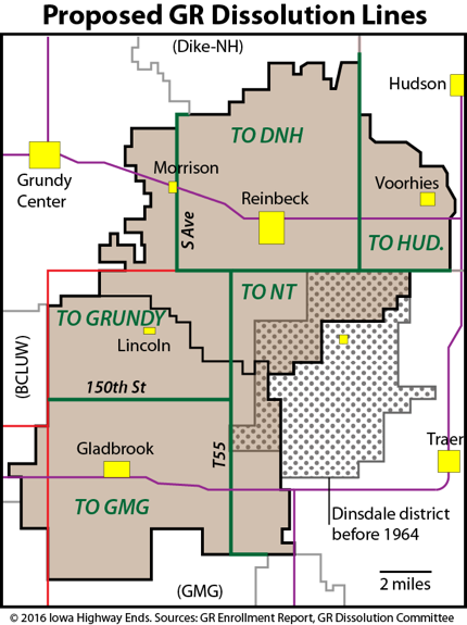
It doesn’t get any simpler than that. Hudson could get all of the district that’s in Black Hawk County (approx. 16½ square miles). North Tama could get everything in Tama County east of T55 (approx. 33½ square miles but possibly as few as 20 students). The north line for GMG would be 150th Street, a mile north of the township line. Grundy Center would make a major advance into Tama County with 32¾ square miles and the town of Lincoln, and then also the town of Morrison in Grundy County. The remainder, including Reinbeck, would be assigned to Dike-New Hartford. DNH had left open the possibility of keeping the Reinbeck building open — but it could be at the expense of New Hartford, which currently has the junior high.

If the dissolution passes, the boundaries of Grundy Center, Hudson, and North Tama would change for the first time in the modern era of Iowa school districts (post-1965). It would be the first major change in the surrounding area since 1992, when BCLUW and GMG officially consolidated and Dike-New Hartford began sharing. (GR merged later but was sharing earlier.) There would be a buffer of sorts separating Gladbrook from Reinbeck, and I’m not just talking about Grundy Center’s new border with North Tama. With GMG in the Iowa Star Conference and Class A football, and DNH in the North Iowa Cedar League and generally on the 1A/2A football cusp (2A next fall), the two towns would be in separate activity spheres except for large-area fine arts events.

The lines are clean and simple, but have one side effect. Because they are drawn on the section line instead of the half-section, students on the borders would go to different districts depending on which side of the road they live on. (The Iowa Department of Education’s lines for Farragut got caught in this trap when the few houses in Farragut on the west side of M16 were assigned to Sidney instead of Shenandoah.)

Judging solely on the basis of attendance at the meeting at the end of March, this proposed dissolution is not likely to pass, in which case nothing changes. But as with any election, it’s the side opposed to the status quo that is usually the most energized.

Oh, and by the way…next school year David Hill will be the shared superintendent for North Tama and Gladbrook-Reinbeck. I wish him luck, because he’s going to need it.

UPDATE 5/31/21: Corrected Dinsdale lines to 1964.

Posted in Schools, Tama County | Comments Off on Draft Gladbrook-Reinbeck dissolution map released
Apr 29

The ‘Oregon Trail’ Generation

With the news that millennials now outnumber baby boomers, I want to pass along this Huffington Post piece that points out not all millennials (and late X’ers) are created equal. I’ve thought for years that Generation Y should be broken up into two groups depending on what you got first, a driver’s license or a cell phone. Thus, this speaks to me.

We were the first group of high school kids to do research for papers both online and in an old-fashioned card catalogue, which many millennials have never even heard of by the way (I know because I asked my 21-year-old intern and he started stuttering about library cards). …

The importance of going through some of life’s toughest years without the toxic intrusion of social media really can’t be overstated. MySpace was born in 2003 and Facebook became available to all college students in 2004. So if you were born in 1981-1982, for example, you were literally the last graduating class to finish college without social media being part of the experience.

Meanwhile, Generation Z is beginning to enter college, and I have e-mails and ClarisWorks documents older than nearly all of them.

Posted in Uncategorized | Comments Off on The ‘Oregon Trail’ Generation
Apr 28

$1.986

I had back-to-back interesting number issues while filling my gas tank recently. (I also have a gas tank that refuses to let the pump run until it gets full, but that’s another issue.)

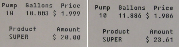
First, I got caught in a “nine-tenths” trap when I could have either an exact number of gallons or an exact amount of payment. That fraction turns out to be worth about three-thousandths of a gallon.

But it’s the second one that I’ve never seen before, and may never see again. The price did not end in nine-tenths of a cent, but six-tenths. On the board outside, it still said $1.999 — I had a 1-cent discount — but the digital pump readout said differently. The difference saved me all of three cents.

Posted in Uncategorized | Comments Off on $1.986
Apr 27

GR dissolution committee meeting tonight

The Gladbrook-Reinbeck dissolution committee will have a public meeting tonight at 5:30 in the MPR in Reinbeck. The agenda is pretty short with only one real new item: “Discussion – Begin boundary line drawing.” I don’t think there will be any real action on that tonight.

I attended the previous meeting.

UPDATE: First draft of breakup lines released (note: Google Doc PDF).

Posted in Schools, Tama County | Comments Off on GR dissolution committee meeting tonight
Apr 26

Council Bluffs highway decommissioning May 1


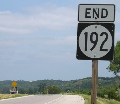
June 12, 2006: The end is here.

West Broadway (US 6) and North 16th Street (IA 192) will be turned over to Council Bluffs for $16 million on Sunday. Stories: Nonpareil, WOWT, KETV, KMTV. I’ve sent an e-mail to the Nebraska Department of Roads about the idea of swapping US 6 and 275 in Omaha; I have not received a response.

Elsewhere, the state is offering $28 million to Waterloo to please take University Avenue off its hands.

Posted in Iowa Miscellaneous | Comments Off on Council Bluffs highway decommissioning May 1
Apr 25

Forty years of Iowa route descriptions posted online

OH HO, what do we have here?

Transfer of jurisdiction agreement number TJ‑318‑0(3)‑‑2M‑86, between the city of Clutier and the Iowa Department of Transportation, transferred that portion of Iowa 318 from Front Street north and east to the east corporation line of the City of Clutier to city jurisdiction on August 18, 1980.

Transfer of jurisdiction agreement number TJ‑318‑0(2)‑‑2M‑86, between Tama County and the Iowa Department of Transportation, transferred that portion of Iowa 318 from the east corporation line of the City of Clutier east to a junction with Iowa 21 at the Tama‑Benton County line near the NE Corner Section 24‑T84N‑R13W to county jurisdiction on July 22, 1980.

To you, this is pretty dry stuff. To me, this is a treasure trove of information that otherwise would have taken days upon days going through microfilm with an un-assured chance of success — and I know this because I did spend days going through 40 years of microfilm of Highway Commission minutes, a decade ago.

The highways available in the list do not include any before the Great Renumbering of 1969, but do include the Great Decommissionings of 1980 and 2003. This means that in there are also the official hard-to-pin-down endpoints of all those spurs, like IA 318, above. Many spurs that survived to 2003 had endpoints closer to downtowns until 1980. (But completeness or not, I’m not keen on going back to Bussey to get a photo at the west city limits.) This will give us official dates, but not necessarily when signs came down or were changed.

There’s information going back all the way to 1936 and 1937, when exact route descriptions were logged for every city and county, but only if the route had the same number through at least 1978, when it looks like all the routes were re-entered. (God bless the township-and-range system.)

This will certainly cause me to do a complete revision and update to my 900s series pages (anyone remember I have these?) and may be the cause for blog posts later.

Big thanks to whoever did this. Kind of makes up for the Sufficiency Log going kaput.

Posted in Highway Miscellaneous, Iowa Miscellaneous | Comments Off on Forty years of Iowa route descriptions posted online