Feb 11

Great River Road to be signed like other Iowa byways

I travel the whole thing and THEN it gets new pretty signs.
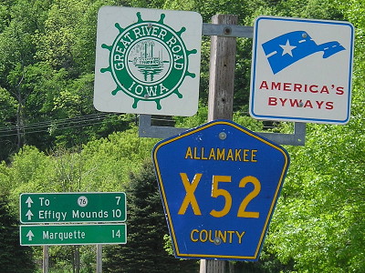

May 14, 2010: The current style of Great River Road shields in Iowa is a square smaller than square highway shields. This is at the north end of old IA 364 in Harpers Ferry.

When the Iowa DOT introduced a “graphic identity” for the state’s 10 official scenic byways plus the Lincoln Highway in 2010, the Great River Road was left out, perhaps because it already had a unique shield. Wisconsin and Illinois use Great River Road shields equal in size to regular highway signs, but Iowa’s were smaller.

At the end of last year, the DOT had a sign letting to replace every Great River Road sign with a larger one matching the new scenic byway style. The GRR logo will be centered in a larger black rectangle with a rounded top and the words “National Scenic Byway” underneath.

The DOT’s byway-signing manual is available online (PDF), with two recent and important changes:

  • The arrows that go under highway shields will now all be 21 inches by 15 inches, conforming to the latest standards in the Manual on Uniform Traffic Control Devices. This is three inches shorter in width than a square shield (24×24), which will annoy me to no end. Arrow shapes that until now have been squares and the “ahead” arrow, which had been interchangeable with left/right arrows (see the IA 96 page for examples of all of these), will be squeezed into this new shape.
  • “Beginning with the 2016 construction season, the Iowa DOT will require Perforated Square Steel Tube (PSST) posts for new sign installations.” That means no more wood, which again, is a change from what’s been used in Iowa since forever. I think the metal poles look flimsier than wood, but they may be better in windy conditions because they’re more flexible.
Posted in Highway Miscellaneous | Comments Off on Great River Road to be signed like other Iowa byways
Feb 10

Keokuk no longer a ‘control city’ on I-172

OLYMPUS DIGITAL CAMERA
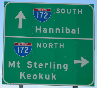
April 20, 2008: Former sign at a road intersecting I-172 in Adams County, Illinois.

I-172 is an interstate spur in far western Illinois connecting Quincy to Interstate 72. For decades, I-72 ended where I-172 began, until a new bridge across the Missouri River was built in Hannibal.

But for at least a decade, signs on the roads intersecting I-172 did not mention Quincy, instead mentioning Mount Sterling, Illinois, and Keokuk, Iowa. (The above is dated November 2002; replacements were up by October 2012.) The interstate reaches neither of those cities and in fact, they’re in two very different directions. Keokuk is the next largest city to the north, via IL 96; Mount Sterling is to the east, via US 24. In that way, I-172 was less a route to Quincy than a bypass of Quincy from I-72 to the routes to get to those cities.

Illinois has replaced all the signs in Clearview. Carthage and Macomb are the new destinations, which make much more sense from a corridor standpoint. Illinois has been upgrading an assortment of roads to four lanes between Galesburg and Quincy — US 34, US 67, US 136, and IL 94. Illinois wants to encourage traffic to use those highways (along with I-74 and I-88), and then US 36, between Chicago and Kansas City. The last part in the “CKC” corridor, the Macomb bypass, could be completed this year.

The state even went so far as to create a new number, 110, specifically to overlap the whole corridor. As far as I can tell, no one uses the number in an everyday manner, not even the state — the number shield is tacked on to larger signs at interchanges and never included in the main part. But Illinois is so into this “corridor” thing that there’s another number, 336, overlapping 110 and the previously-numbered routes between the north end of I-172 and Macomb. That’s the one that gets on the big signs. Illinois could’ve given more prominence to 110 and not dealt with 336 at all, but then, efficiency isn’t the state’s strong suit.

Although Keokuk never connected to I-172, for a time the city got more respect on signs in Illinois than it did in Missouri, which leaves it out of every interchange on the Avenue of the Saints until US 61 splits from the four-lane near the Iowa border.

Posted in Highway Miscellaneous | Comments Off on Keokuk no longer a ‘control city’ on I-172
Feb 09

There is a piece of Vermont that sticks into New Hampshire

A combination of having politics and state borders on the mind…

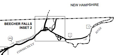
The Connecticut River forms the border between Vermont and New Hampshire, two states that would fit comfortably inside Iowa. Halls Creek forms the western part of the border between New Hampshire and Quebec. But Halls Creek flows into the Connecticut just south of the 45th parallel (Quebec’s border with Vermont and Upstate New York, at least ideally) while the Connecticut River takes a tack east.

That means at the town of Beecher Falls, Vermont, the Green Mountain State’s northern border intrudes less than 2 miles into the Granite State.

vtnhinject

That’s from the Vermont Agency of Transportation’s map of the “Town of Canaan” in Essex County. Boundaries in New England far predate township-and-range, of course, and looking at a map of Vermont’s “towns” makes you appreciate that system that much more.

Here’s a link to the spot on Google Maps (at least, I hope it’s a link). US 3 runs on the New Hampshire side.

The New Hampshire primary is today, and there’s one burning (Bern-ing?) question: Will Vermin Supreme get more votes than Jim Gilmore?

UPDATE: Yes he did! (241-125 after midnight CST)

Posted in Maps | Comments Off on There is a piece of Vermont that sticks into New Hampshire
Feb 08

DOT plans to change cloverleaf at 35/30


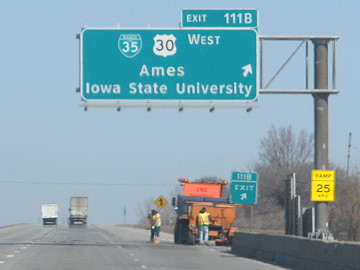
March 25, 2010: It turns out I’ve only photographed this exit once because watching for merging traffic takes priority.

There are fewer pure cloverleaf interchanges in Iowa than you might think, but two of them – I-80/I-380 and I-35/US 30 – have one big thing in common: The most important traffic movement is an inner loop. In this case, it’s northbound I-35 to westbound 30, traffic from Des Moines going to Iowa State University.

A meeting next week and a KCCI story (warning: autoplay) show that the DOT is out to change that (PDF), creating a flyover ramp to replace the loop. The result would be a “flipped image” of the current I-380/US 20/US 218 interchange in Waterloo. All exiting traffic on northbound 35 would take a ramp and then that ramp would split into eastbound and westbound 30. This plan puts some additional pressure on closing the intersection on 30 to the east of the interchange, where I noticed a long backup of traffic wanting to turn left in my most recent visit to Ames.

As for 80/380, that’s going to be replaced as well. Both of these ramps could be in their new configuration by the end of the decade.

Posted in Construction | Comments Off on DOT plans to change cloverleaf at 35/30
Feb 05

Sullivan’s corner on the Iowa-Missouri line

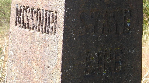
Along Iowa’s southern border, a string of nearly forgotten iron posts marks where Iowa ends and Missouri begins. The westernmost marker, once the northwest corner of Missouri, is today at the southernmost point in the slightly bent line west of the Des Moines River.

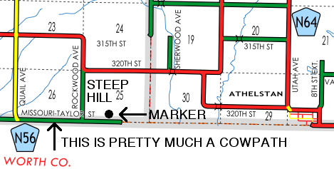
I’ve written extensively about the Sullivan Line before. (See also this link from IPTV/The Goldfinch.) Around the same time I wrote that, a Missouri surveying crew was seeking out posts erected along the line in the 1850s and succeeded. Their story was featured in American Surveyor magazine in 2006 (PDF), and is worth the read. Because the northwestern part of Missouri wasn’t attached to the state until 1837, the survey ended in Taylor County, west of the now-unincorporated near-ghost-town of Athelstan. In January 2012 and again in my circumnavigation trip last year, I went to the marker. It’s not easy to get to.

Advice/Disclaimer: Do not attempt to visit this marker within 48 hours of a precipitation event, 72 after a good drenching. Four-wheel drive isn’t necessary but it’s not a bad idea either. Professional roadgeek, open course.

MOmarkermap

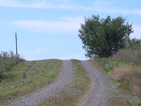
Red is gravel, green is dirt. The road turns south after the marker. What this map doesn’t show is the marginally better gravel-road path on the Missouri side to the marker (take the first gravel road east, then north), but again, turning around really isn’t an option.


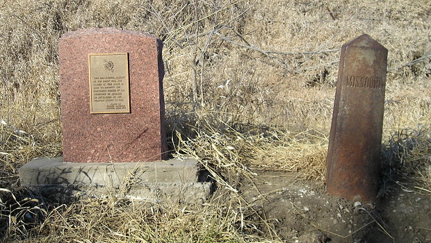
January 10, 2012: The original start of Sullivan’s Line, right, and a complementary stone posted decades later. A news story in 1931 said the iron marker was in the center of the road.

“This iron marker, remnant of the Honey War, was placed at this point in 1850 to identify the northwest corner of the Territory of Missouri as determined by the Sullivan Survey in 1816. Placed by Virginia Daughters Chapter, NSDAR 1989”


October 2, 2015: Above, iron border marker looking west; below, looking west from the marker, Iowa on the right

Posted in Geography, Iowa Miscellaneous, Maps | Comments Off on Sullivan’s corner on the Iowa-Missouri line
Feb 04

Input wanted on improving I-80

If you haven’t been all focused on the caucuses, you may have noticed a few news articles about the DOT undergoing an all-encompassing study on I-80.

Right now, the study is about asking for input; it’s an “online public information meeting.” It starts with a survey online. The website has various moving parts so I’m linking to the main page and then going to cut out the middleman and link directly to the Public Involvement Plan PDF.

A long-term (and I mean loooong-term) plan to six-lane I-80 all the way between Des Moines and Davenport has to start somewhere, and this study/survey is the first step.

Posted in Highway Miscellaneous | Comments Off on Input wanted on improving I-80
Feb 03

Smoothing out Swiss Valley Road curve

The point east of Peosta where US 20 angles sharply northeast toward Dubuque has been there since 20 was realigned in Dubuque County in 1959, near where the four-lane road ended at the time. In the decades since, traffic has grown by leaps and bounds and the intersection has become dangerous.

The state has a long-term plan to turn the angle into a more gradual curve, but not all at once. The first part of the plan, scheduled for 2019 (PDF), reshapes the westbound lanes, but keeps an at-grade intersection. The long-term plan (PDF) moves the eastbound lanes to the same curve and builds an interchange with frontage roads, moving part of North Cascade Road farther away from 20. There’s a meeting about the plan tomorrow.

Posted in Construction | Comments Off on Smoothing out Swiss Valley Road curve
Feb 02

Clearview is dead

OLYMPUS DIGITAL CAMERA
September 13, 2015: The exit sign for the new US 63 interchange with IA 3 is signed in Clearview. Note the “L”s especially, and how the lowercase letters aren’t that much shorter than the capitals. The interchange replaced a four-way stop when 63 was upgraded to four lanes between Waterloo and US 18/IA 346 in 2012.

The Federal Highway Administration officially terminated all use of the Clearview font on road signs last week. Stories available at Popular Mechanics (whose top photo, notably, has a sign that is not in Clearview) and CityLab.

The Iowa Department of Transportation stopped issuing new-sign contracts with Clearview about a year and a half ago. The new font is not identical to what was used in Iowa for decades before Clearview, though; it’s skinnier. All the existing Clearview signs can stay until they are replaced through natural wear and tear, which means that it will be with us for decades to come. The “genericization” of interchange signing in Iowa was done entirely in Clearview, so those will gradually progress to a mix depending on what exit you’re at.

(h/t Matt Stinn and Cristopher Sturtz)

Posted in Highway Miscellaneous | Comments Off on Clearview is dead
Feb 01

It’s caucusing time

Because of my job, I am not able to participate directly in the first-in-the-nation Iowa caucuses. I can, however, see candidates, and I saw nearly a dozen of them in this election cycle — so many that some have dropped out already. (Walker, Perry, Kasich, Graham in passing, Huckabee, Rubio, Clinton, O’Malley, Cruz, Sanders, Fiorina. Ironically, not Santorum this campaign cycle, despite his virtually camping out in the state. Paul had to cancel an appearance at Cornell College and Jindal ended his campaign the day before he was supposed to be in Tama.)

Some quick thoughts:

In closing, with an eye on what happened in 2008, the traditional election official’s prayer: “Dear Lord, please, let the winner win big.”

UPDATE: One more candidate. One more yuuuuugge candidate.

UPDATE 2: eep (and one of them appears to be in Tama County)

Posted in Iowa Miscellaneous | Comments Off on It’s caucusing time
Jan 29

Oh look, chopped liver

Spot the missing word:

Whether you prefer to read siouxcityjournal.com on your laptop, tablet or phone, our new design gives you an optimal viewing experience tailored to your digital device of choice.

Give up? It’s “desktop”. The SCJ and the Waterloo-Cedar Falls Courier have made their websites “much more visual”, which is code for “optimized for mobile”, which is code for “You want to read TEXT? On a MONITOR? So passe. Silly oldthinker.”

On one full-size browser window, the Courier’s website shows 10 headlines, and that shrinks to five if the window is less than 1000 pixels wide. By contrast, the Quad-City Times, still using the old Lee website design, shows seven in a “quick clicks” line, five in a rotating window, and seven in a vertical list of headlines.

Posted in Iowa Miscellaneous | Comments Off on Oh look, chopped liver