May 08

RAGBRAI to pass Kinnick Stadium, maybe UNI-Dome

Weeks after the 2015 RAGBRAI route was announced in March, the finalized route in and out of Coralville was added to the map. On the Saturday morning of the ride, bicyclists will go past “the corner of Melrose and Melrose” to see Kinnick Stadium and then the Old Capitol. (No word on if there will be donation jars for Kirk Ferentz’s buyout.) This route will also eliminate any ambiguity over whether University Heights has been visited by RAGBRAI.

The route inside Cedar Falls remains ambiguous, but with the University of Northern Iowa prominently figuring in the city’s RAGBRAI website and an exit via Hudson Road, passing by the UNI-Dome wouldn’t be hard to do.
Here’s my list of every town visited by every RAGBRAI.

Posted in Maps | Comments Off on RAGBRAI to pass Kinnick Stadium, maybe UNI-Dome
May 07

Cleghorn school will close

The 94-year-old school building in Cleghorn will educate students for one more month. The Marcus-Meriden-Cleghorn district will close the building, used for fourth through sixth grades, to save $130,000 a year, says the Sioux City Journal. The district will still use the gym in Cleghorn.

MMC was in talks with Remsen-Union earlier this school year, but whole-grade sharing proposals fell apart over where the high school would be. Now, R-U is in a dire enough position that it’s been talking to Le Mars, which is an all-give-and-no-take situation. (Two-way sharing is a non-starter, the Le Mars Sentinel was told, and a name change would be supremely doubtful.)

Cleghorn is the fifth Iowa town this school year to be faced with the closure of its only public school, the same number as last year.

Posted in Schools | Comments Off on Cleghorn school will close
May 06

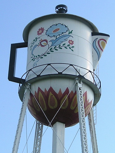
Iconic Stanton water tower taken down


September 17, 2014: This water tower in Stanton has looked like a coffee pot for 45 years.

The water tower in Stanton painted and tweaked to look like a coffee pot has been taken down, reports the Omaha World-Herald. It will be moved to the Swedish Heritage and Cultural Center after the cost of repairs became too much, the paper says. There is a newer tower, shaped like a coffee cup, on the south side of town.

Posted in Iowa Miscellaneous | Comments Off on Iconic Stanton water tower taken down
May 05

2015 Iowa highway map released online

Two months later than expected, the official state transportation map is available through iowadotmaps.com. Changes are minimal, but Tama County had a few of them.

  • The Iowa Juvenile Home is no longer marked.
  • The Tama-Toledo “urban area” is no longer extant (no yellow area).
  • T69 north of D65 is marked as paved, although it’s hard to tell because the lettering itself takes up most of the line. So is A26 in Allamakee County.
  • IA 152, IA 370, and old US 34 to Plattsmouth are now county roads.
  • IA 92 is rerouted around Muscatine both on the main map and inset.
  • N64 to Athelstan in Taylor County, long marked as paved and marked as bituminous in a 1997 county map, is gravel. The road itself been gravel since at least fall 2009, as seen on Google Street View. It’s very possible this was a reversion in the 2000s, after the community disincorporated.
  • Speaking of disincorporation, Millville’s new status is so reflected.
  • One piece of the past hanging around: Old IA 60 at the Minnesota state line still appears as a black line, although the road literally was obliterated after completion of the four-lane.

The state will be switching to an every-two-years pattern on paper maps. This KCRG story leads me to think that 2015 is the first two-year printed map. (That may also explain the delay.) Printing maps in odd-numbered years would best sync with changes in the governor’s office.

Posted in Maps | Comments Off on 2015 Iowa highway map released online
May 04

Options out for major makeover of IA 141 interchange

Back in ancient times (the 1970s), “Rider Corner” was a modest rural trumpet interchange on I-35/80, named after the railroad siding at Meredith Drive.

Now, it’s a bustling suburban area, with a SuperTarget nearby and an underpowered four-lane to the north. On Tuesday, the DOT will hold a public meeting to take a step toward redesigning the area, along with adding an interchange at 100th Street.

The alternatives are varied. They start with the addition of a simple flyover ramp from 35/80 to 141 plus a diamond interchange at 100th, and add flyovers and frontage roads from there.

Posted in Construction | Comments Off on Options out for major makeover of IA 141 interchange
May 02

Marshalltown makes the Onion

Iowa Restaurant Patron Can Remember Every Breakfast Ruined By Presidential Candidates

America’s Finest News Source made a slight misstep with the Nixon reference, as Iowa’s “first in the nation” caucuses didn’t become A Thing until 1976.

Posted in Iowa Miscellaneous | Comments Off on Marshalltown makes the Onion
May 01

One motel down, one to go up on US 20

The Sioux City Journal‘s Tim Gallagher drove US 20 recently to check out a motel being torn down near Correctionville, and mentioned one planned for US 20/59 at Holstein.

Mom-and-pop motels are nowhere near as prevalent as they used to be, often limited to intersections not worth even a Super 8 and large tourist traps (Wisconsin Dells, Orlando).

Elsewhere on the SCJ’s site is a much more entertaining story/photo collection: Cats in Hats!

Posted in Highway Miscellaneous | Comments Off on One motel down, one to go up on US 20
Apr 30

I should get this shirt

As seen at the Madison roadgeek meet earlier this month (because stereotypes happen):

(link)

Posted in Uncategorized | Comments Off on I should get this shirt
Apr 30

Bus travel challenges rural school districts

Story from Iowa Farmer Today. Busing, both in terms of time for students and gasoline costs, has significant effects on rural districts’ budgets.

Posted in Schools | Comments Off on Bus travel challenges rural school districts
Apr 29

Google kills Classic Maps

You know how, when new products come out that are worse than the old ones, or are incompatible, or are inextricably linked with “the cloud”, or just plain don’t do what the old one does, the rebuttal is “you don’t have to use it”?

Well, here’s another piece of evidence against that rebuttal, because eventually, you don’t have a choice:

Soon, the updated version of Google Maps will become your desktop Maps experience. You’ll no longer be able to use the older, classic Google Maps.

The classic Google Maps, i.e., the one that works. The one without zillions of squares. The one that lets me type “from: CID to: la crosse wi to: mankato mn to: CID”, knows exactly what I mean, and creates a route accordingly. The one that doesn’t suck up the CPU to zoom in on Street View. And the one that works in Safari for Mac OS 10.6.8. As of Tuesday, GMaps defaults to “lite” mode, but chews up CPU cycles and no longer has zoom levels on the scale, just plus/minus.

For the moment, iPhoto Places appears to be unaffected (but still has the long-standing map-jumping issue). If anything happens to that I’m going to be furious.

Posted in Maps | Comments Off on Google kills Classic Maps