Apr 28

No US 30 Tama-Benton work until 2020

This isn’t an unexpected situation, given that the 2014-19 plan did not have any entries for it, but finishing making US 30 four lanes in Tama and Benton counties won’t start until 2020 at the earliest, reports the Cedar Valley Times.

The news in the short bit would be that the part in Tama County could be done first, even though it is the much hillier half, because ROW acquisition is moving along.

I’ve mentioned before that this new 30 would run just south of the existing road in Benton County, and just north of the existing road in Tama County. I did not point out a very big practical reason a four-lane has to be all-new: The current two-lane has a milled rumble strip on the centerline, intended to prevent head-on collisions. (Although I see no reason why the pavement couldn’t be ripped up and the new roadbed built in the same place. *shrug*)

Posted in Highway Miscellaneous | Comments Off on No US 30 Tama-Benton work until 2020
Apr 27

Aggregation of Iowa counties’ presidential election trends

The title above is a nonpartisan version of a Washington Post blog entry, “The Democrats’ white-voter problem — in 2 maps”. The two maps in question are county-by-county preferences for the last four presidential elections (two won by G.W. Bush, two by Barack Obama), and county-by-county trends for Bill Clinton’s two elections vs. Obama’s.

On the first map, most of Iowa is part of a collection of counties in the Upper Midwest that has either waffled between parties or been solidly Democratic (Gore-Kerry-Obama-Obama). US 169 is a decent boundary for this. Overall, only six counties have mirrored the national electoral vote and split 2-2 during that time period (although not necessarily in the same way): Allamakee, Bremer, Greene, Marshall, Union, and Winnebago. Eight more have mirrored the national popular vote and split 3-1 for the Democrat, including Cedar, which ended Election Day 2000 in a tie but gave a 2-vote edge to Gore in the final canvass. Fourteen went 3 R, 1 D. The remaining 71 counties are split between solid D or R, with the former concentrated in the eastern part of the state and the latter in the west.

The Clinton-Obama map brings a lot more blue, light red, and neutral to the state. Guthrie County is the tip of a triangle-ish or hooked-T-shaped area of the country running south to the Gulf of Mexico and east through Tennessee into western Pennsylvania that split those four elections (’92, ’96, ’08, ’12) two and two party-wise. In that map, Grundy, Humboldt, Madison, and Warren are the only counties on or east of US 169 that went Republican all four times, the direct opposite of what happened nationally.

Posted in Maps | Comments Off on Aggregation of Iowa counties’ presidential election trends
Apr 25

Impending loss of school weighs on Gladbrook

The Waterloo Courier had a piece Sunday interviewing Gladbrook residents and business owners about what they thought was going to happen to the town after the school closes next month. Some acknowledged what Gladbrook is up against, but the paragraph of no-comments says just as much.

In the interest of trying to find a bright side, here’s a plug to the Gazette’s visit to Gladbrook a month ago.

Posted in Tama County | Comments Off on Impending loss of school weighs on Gladbrook
Apr 24

IA 152 is officially gone


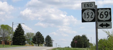
April 25, 2005: The “east” or “south” end of IA 152, right at Osceola’s north city limits. (Can’t believe this picture is a decade old.)

Jason Hancock has been checking the status of signs for IA 152 on a regular basis. The signs were taken down in the first half of April, most likely April 1, despite a decommissioning back in July and 152’s absence from the online county map since late last year. Jason’s speculation that this was about snow removal is a likely explanation, and possibly also because there was construction on its bridge over I-35 last year.

The decommissioning of IA 152, one of the shortest highways in the state even before the Second Great Decommissioning, leaves three numbers in Clarke County (I-35, US 34, and US 69). It was the second time the number was used in the county, relocated from being the spur to Murray.

Posted in Highway Miscellaneous, Maps | Comments Off on IA 152 is officially gone
Apr 23

Civil War program in Traer tonight


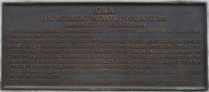
Dec. 29, 2012: Text of monument for the 14th Iowa at Shiloh National Battlefield. A recap of my visit can be found here.

A program at the Traer Museum at 7:20 tonight will honor Tama County’s “Wolf Creek Rangers” of the Civil War, the Waterloo Courier reports. The Rangers were among the Iowa farm boys who fought in the “Hornets Nest” part of the Battle of Shiloh.

Posted in Tama County | Comments Off on Civil War program in Traer tonight
Apr 22

North Iowa sells Thompson building

For $1. The building’s new owners intend to keep it and turn it into apartments, and make the gym available to the public.

Posted in Schools | Comments Off on North Iowa sells Thompson building
Apr 22

Luther taking steps toward disincorporation

Months after the old school in Luther was lost to history, the same may be about to happen to the town itself.

The state City Development Board held a hearing regarding Luther’s status earlier this month (PDF). Luther was in the news at the beginning of the year over the fact it could not afford state-mandated sewer upgrades.

Luther’s disincorporation, along with Center Junction’s, would leave 943 incorporated places in Iowa.

Posted in Iowa Miscellaneous | Comments Off on Luther taking steps toward disincorporation
Apr 21

Meetings seek input on Lincoln Highway legacy


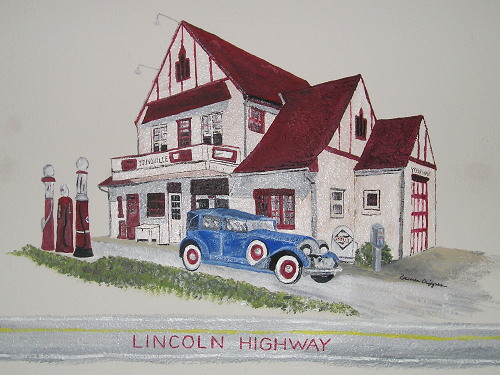
September 28, 2014: Art of Youngville Station, inside Youngville Station, on the Lincoln Highway in Benton County.

The Lincoln Highway Heritage Byway group is holding meetings across Iowa to get input on priorities for the future of the historic route, report multiple sources including the Ames Tribune and Clinton Herald.

The Benton County meeting is tonight in Belle Plaine. The Tama County meeting is Thursday in Toledo. Here is a complete list of meeting times from the group.

Posted in Geography, Highway Miscellaneous | Comments Off on Meetings seek input on Lincoln Highway legacy
Apr 20

On legacies, and not being the only one out to visit every Iowa town

Or: Can someone’s thunder be stolen if it isn’t raining yet?
OLYMPUS DIGITAL CAMERA
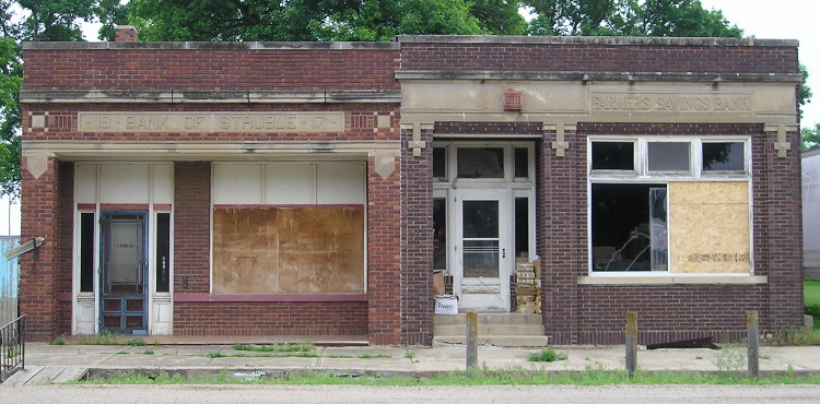
June 5, 2014: Not the only buildings in Struble, but close. Struble, pop. 78, is near the Plymouth/Sioux county line in northwestern Iowa.

I’ve been chugging along in my Iowa highway travels for more than a decade, and am nearly to my goal of traveling every state-maintained route. In a New Year’s resolution, I formalized a goal to visit every incorporated place in Iowa. I figured I’ll have more and better things to say when I got closer to or achieved those goals.

Then BOOM — someone from Keokuk puts up a Tumblr account with a goal to photograph not only every incorporated town, but the unincorporated ones as well — and he gets interviews with Vice magazine* and Kyle Munson. He’s soliciting money from the Internet to do this, something not on my radar for assorted reasons.

Cody Weber and I have different yet similar goals on how we want to photograph Iowa. My first focus has been on Iowa’s highways and their signs. That field, after a static period, is changing in different ways. When I’ve had time, or something caught my eye, I have expanded my range, especially picking up on school buildings and post offices across the state. But I am not as intent on photographing the towns in general. That could be because as a lifelong Iowan, I’m used to seeing sparse small-town downtowns. It could be because I am doing all this with a 10-year-old point-and-shoot camera. Mostly, I’m guessing it’s not spending as much time in any one place as a project like Weber’s requires.

As Weber has found out, engaging in a project that captures disappearing rural Iowa runs the risk of ruin porn. Of course, I am not above that at all — many school pictures fall under that category, as does the photo at the top of this entry. If something like this is going to be done, don’t let it be as a drop-into-flyover-country report — although Weber told Vice he plans on leaving Iowa when he can.

Unlike Weber, I would love for my legacy to be Iowa. If my highway pages, city highway histories, and school district timeline have benefited others, I am thrilled (with bibliographical acknowledgement as necessary). I have occasionally wondered what I can do with the photos I have taken — perhaps get a book published, like Dave and Barb Else did with schools, or Carson and Connie Ode did with their 99-county yearlong tour. I have already left little marks with my Des Moines Register columns about the Lincoln Highway and the closure of the Manilla school. The Iowa Office of the State Archaeologist took 7,000 photos of towns in six years, and I could augment that collection, eventually. I went across Iowa’s Lincoln Highway route in its centennial year, and that would be one category rich for visual storytelling.

I am the first to admit that my collection is esoteric. At the same time, though, I think it can be valuable precisely because it is esoteric. There is plenty of time to think about that legacy. For now, I am content to do what I can with what I have — but a dedicated webpage or two on this site probably wouldn’t hurt. (Not Tumblr. I can’t stand Tumblr’s structure.)

*Why Vice? Weber’s non-Forgotten-Iowa photographs have a Williamsburg vibe, and I’m not talking about the home of the Raiders.

Posted in Iowa Miscellaneous, Maps | Comments Off on On legacies, and not being the only one out to visit every Iowa town
Apr 18

Nothing happening in Ames today

Nothing at all.

noveishea

Posted in Iowa Miscellaneous | Comments Off on Nothing happening in Ames today