Jan 26

State gives Hamburg, Farragut time to work out differences

Omaha World-Herald:

The Iowa School Budget Review Committee has granted requests from the Farragut and Hamburg school districts for additional budget authority, allowing them to spend dollars beyond those typically allowed for general fund expenses.

Other stories: KMA (Tuesday), KMA (Thursday), Nebraska City News-Press.

The requests don’t mean the districts won’t be forcibly dissolved, but it does allow leeway to work things out, most specifically where students in grade 6-8 will go to school. No matter the decision, the original Hamburg High School building will close.

Posted in Schools | Comments Off on State gives Hamburg, Farragut time to work out differences
Jan 24

Living the dream

Illinois manager added to injury-depleted roster (ESPN)

(As a former basketball manager, I can’t not post this.)

Posted in Sports | Comments Off on Living the dream
Jan 23

Online Iowa map updated to include new US 34 bridge


Oh ho, what do we have here?

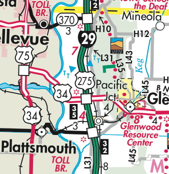
The 2015-16 (remember, two-year) state transportation map won’t be out for a month and a half or so, but one change has already been made for the benefit of those who look online. It’s in section 11 of the segmented map, or of course in southwest Iowa in the big one.

A little “v2” in the lower-right corner of the map indicates there’s been a change, and it’s this one — the addition of the new US 34 four-lane into Nebraska. The interchange with US 75 is premature, because it’s only an intersection right now. No mileage has been added yet.

No other changes were made to the map, and IA 370 is still there as you can see. This could be the only map that shows 370 and new 34 at the same time. (Also, if you look closely, you can see the greater Pacific Junction metropolitan area.)

Posted in Maps | Comments Off on Online Iowa map updated to include new US 34 bridge
Jan 22

Why not stick with ‘AHSTW’?

Walnut students have been participating in AHST athletics for years, but they just started in grade-sharing this school year. The districts are likely headed toward consolidation and Walnut’s near century and a half of independence will end.

However, while it’s the obvious answer, “AHSTW” apparently isn’t an option for the merged district’s name going forward.

Both districts “agreed that AHSTW is something they don’t want to go with,” Green Hills AEA administrator Lane Plugge told KMA at the end of October. Last week, in an Omaha World-Herald article about expansion of the school in Avoca, AHST’s superintendent said there would be a name given in the coming weeks.

The history of the AHST name has something rare (if not unique) in Iowa: A town’s name was added back in. When the Avo-Ha district merged with Shelby (officially in 1996), the town of Tennant was included in the new acronym.

If they’re not going with the acronym, specific geographic options are hard to come by. The combined district would be in south Shelby and northeast Pottawattamie counties. The “Nishnabotna” name is taken, at least for a while. I-80 runs right through the middle of the district, so AHSTW could be like I-35 of Truro, which has the perfectly matching nickname of Roadrunners.

Posted in Schools | Comments Off on Why not stick with ‘AHSTW’?
Jan 21

North Tama full-court basketball shot

Tuesday night against Dunkerton. From the opposite-side volleyball line.

(NT won 63-59, by the way.)

Posted in Sports, Tama County | Comments Off on North Tama full-court basketball shot
Jan 21

Collins-Maxwell-Baxter athletics split ahead?

Austin Draude pointed me to this Newton Daily News article that’s pretty much a bolt out of the blue: The very-long-term Collins-Maxwell-Baxter athletics sharing agreement may be falling apart. According to the article, there are some complaints about the location or split of games, and favoritism toward one side or the other. A coach and students refute that.

The two districts are wholly separated except for athletics. Neither can field an 11-man football team on its own, and there aren’t many options in the surrounding area.


Posted in Schools | Comments Off on Collins-Maxwell-Baxter athletics split ahead?
Jan 20

County maps now default to color versions

Over the past year, the Iowa DOT has worked to spiff up the interface for the iowadotmaps.com domain and the maps linked from there, including the individual county PDF maps. The images of each county and its towns, and their clickable-map areas, have become more advanced.

Last weekend or thereabouts, a change was implemented that affects pathnames and perhaps even the impression the maps give.

  • This link style used to be the default (just insert the county name), but now gives 404 errors: http://www.iowadot.gov/maps/msp/pdf/tama.pdf
  • This link style used to bring the color map, with colors corresponding to the the surface type of non-state-maintained roads (all gravel roads are red), but now also gives 404 errors: http://www.iowadot.gov/maps/msp/surf/muscatine.pdf
  • Now, the default map — the one you get when you click on the county name at the top of each map page — is the colored surface map, with “-co” appended to the end (note also that someone with Web savvy has replaced the “%20” indicating a space in the filename with a hyphen): http://www.iowadot.gov/maps/msp/pdf/black-hawk-co.pdf
  • If you want just the black-and-white, that now has a “-bwco” suffix. Just type in the county name — “ringgold”, “cerro-gordo”, etc. — and you’ll see the version that has steadily evolved since the early days of the Iowa Highway Commission.

Some pages still have “/surf/” for the color map linked at the side, but in general, clicking on either the county name at top once you’ve reached a county page or “Color map” on the right side will bring up a map with the third bullet’s pathname.

All the county maps have been updated to versions dated Jan. 1, 2014, with a notable Clarke County retcon that killed off IA 152 before it actually happened.

It’s not a huge change in the scheme of things, but one worth noting. If anything, the maps now really highlight how many miles of gravel road run in every county.

Posted in Maps | Comments Off on County maps now default to color versions
Jan 19

Traer Theatre closed indefinitely

Last week’s fire at Simply Blooming in Traer has forced the theater next door to close until further notice. The building, which shares a wall with the flower shop, got soot all over everything.

This is not good at all. Lots of money had to be raised to get the theater back up and running.

Posted in Tama County | Comments Off on Traer Theatre closed indefinitely
Jan 17

Rock Chalk conference championships

ESPN College Gameday comes to Iowa State today*, the Cyclones’ first ever appearance on the show (basketball or football), and the fourth-to-last power-conference school to be featured either as the home or away opponent. If ISU was ever going to get it, this is the only way it was going to happen — at Hilton Coliseum against Kansas.

In 107 years of playing in a conference in basketball, the Kansas Jayhawks have won 42 outright conference championships and shared 15 more. That’s starting in 1907-08, Phog Allen’s first year, and continuing right through Bill Self’s decade of dominance.

Put another way, Kansas has won a conference championship more often than not. The Jayhawks have had one seven-year drought (1979-85), one six-year drought (1916-21), and one five-year drought (1961-65).

So when the Jayhawks assume a divine right of king of basketball…they don’t say it without some history to back them up. And when you come at the king, you best not take an obvious charge on your home court with five seconds left miss.

*Preceded, somehow, by the Travelocity Roaming Gnome getting into a staring contest with Fred Hoiberg.

Posted in Sports | Comments Off on Rock Chalk conference championships
Jan 15

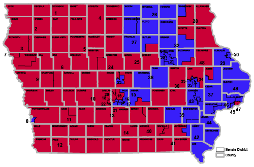
Legislature maps symbolize Iowa’s rural-urban split

With the 2015 Iowa Legislature now in session, it’s a good time to look into the maps and composition of district control. Republicans control the House 56-43 (pending one election in the west), and Democrats hold the slimmest edge in the Senate, 26-24.

First, a map without lines. (All of these are based off the Legislative Services Agency.)

This is 13 districts’ worth of representation in the Senate, all in Republican hands, comprising about half of Iowa’s land area. The east border runs from Lynnville and Lineville around Des Moines’ suburbs to Randall and then north to Lake Mills. Excluded are two holes on the west side: One is held by Republican Rick Bertrand in Sioux City, a Senate district with two House Democrats, and the other one is Majority Leader Michael Gronstal’s. Gronstal is the only Senate Democrat whose district lies completely west of I-35.

When you bring the rest of the state back in, here’s what it looks like, first by Senate district lines only, then with counties superimposed. (Election maps with results are still available on KCRG’s website. You can also zoom to street level maps from the LSA.)
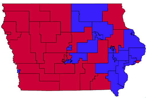
The highway divisor in this one: There’s only one Republican wholly east of counties on and along the US 151/218 line from Dubuque to Cedar Rapids to Keokuk.

Using numbers sent to me by the LSA shortly after redistricting was done, here are distinctions by size and party for the 2015 Legislature*:

  • House Republicans have nearly 85% of the state’s land area.
  • Senate Republicans have nearly two-thirds of the state’s land area.
  • Of 29 House districts over 1100 square miles, Republicans have 26.
  • Of 23 House districts under 26 square miles, Democrats have 21.
  • Of 11 Senate districts over 2000 square miles, Republicans have 10.
  • Of 11 Senate districts under 50 square miles, Democrats have 9.
  • There are only three Senate districts between 50 and 110 square miles in size, and only nine between 110 and 1100 square miles.

There are 36 counties — really 34 plus Council Bluffs plus Cumming — partially or entirely in Senate Democratic territory, and six of those are Mary Jo Wilhelm’s in northern Iowa.

By one metric, Wilhelm has one of the most rural Democratic districts; District 26’s largest city is Charles City (7652). For Tod Bowman in District 29, his largest city is Maquoketa (6141). Theirs are the only two of 26 Democratic Senate districts that don’t have all or part of a city with a population of 9500 or greater. Conversely, just seven of 24 Republican Senate districts contain all or part of a city above 26,000 — including Hubert Houser holding the very east end of Council Bluffs — and three of those are exclusively Des Moines suburbs.

In other words, I just dropped three maps and a whole bunch of numbers to reinforce what everyone understood already: Democrats predominate in Iowa’s urban areas, and Republicans in the spread-out and shrinking rural areas.

When you look at the maps this way, it becomes evident that despite Iowa’s independent redistricting process, there may be few truly flippable Senate districts. The ones to look at are those that pair a rural House district with another House district based around a small or medium Iowa city. District 5 with Fort Dodge, the one Democrat Daryl Beall was ousted from, would be an example (and really, the one that makes this map exercise possible).

With such similarities between members of each party and characteristics of their districts, the rural-urban split may get lost in general partisan attitudes. It might flare up in debate over the gas tax, or limits on when school can start.

*These statistics make the assumption a Republican will win the House special election to fill the seat vacated after its occupant won the race for Joni Ernst’s Senate seat. If that doesn’t happen, I will revise accordingly.

Posted in Iowa Miscellaneous, Maps | Comments Off on Legislature maps symbolize Iowa’s rural-urban split