Our very own Christy Calderwood was crowned the 2015 Iowa Pork Queen tonight in Des Moines! pic.twitter.com/oddz0OWjWw
— North Tama HS (@NTRedhawks) January 29, 2015
Iowa has been the only state with a pork queen for more than two decades.
Our very own Christy Calderwood was crowned the 2015 Iowa Pork Queen tonight in Des Moines! pic.twitter.com/oddz0OWjWw
— North Tama HS (@NTRedhawks) January 29, 2015
Iowa has been the only state with a pork queen for more than two decades.
One of Iowa’s oldest interchanges is on its way out.
IA 415 in Polk County between Des Moines and Ankeny was upgraded to four lanes, with a grassy median, in two stages: Broadway to Northeast 54th Avenue in 1959, and from there to the old Y-intersection with IA 160 in 1961. (A very short piece that goes under the railroad tracks and past the then-brand-new Firestone tire plant became four lanes as World War II was winding to a close.)
Included in that 1961 upgrade was a full diamond interchange with Northeast 66th Avenue. Half a century later, that interchange with its small underpass and short ramps is going to be removed. It will be replaced with a standard intersection with traffic signals. The DOT will hold a meeting about the project Feb. 5, but the plans are already online.
Ironically, although that part of IA 415 is one of the oldest rural non-interstate four-lanes in Iowa, US 69/Northeast 14th Street just to the east remains two lanes to this day. (Why did that not change at least 20 years ago? It’s baffling.)
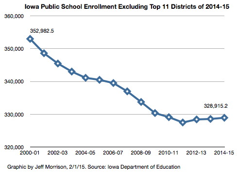
The state’s annual Condition of Education Report (PDF) was issued last week and has plenty of statistics. One being brought up often in news articles is the increased number of minority students, although if you look in the charts (p. 11) the percentage is much higher in the state’s 11 largest districts (enrollment 7500-plus).
Here are two other notable statistics that, along with the one above, says more about the condition of overall enrollment:
• At the beginning and end of a 25-year period, from 1988-89 to 2013-14, public school enrollment increased less than one-half of 1 percent (476,771 to 478,921). (p. 3)
• In 2013-14, 44 percent of Iowa’s school districts educated 12 percent of Iowa’s school children. Those districts have a certified enrollment under 600. Nearly one-third (31.4 percent) of K-12 students are in the state’s largest 11 districts. (p. 5)
The Iowa School Budget Review Committee has granted requests from the Farragut and Hamburg school districts for additional budget authority, allowing them to spend dollars beyond those typically allowed for general fund expenses.
Other stories: KMA (Tuesday), KMA (Thursday), Nebraska City News-Press.
The requests don’t mean the districts won’t be forcibly dissolved, but it does allow leeway to work things out, most specifically where students in grade 6-8 will go to school. No matter the decision, the original Hamburg High School building will close.
Illinois manager added to injury-depleted roster (ESPN)
(As a former basketball manager, I can’t not post this.)

Oh ho, what do we have here?
The 2015-16 (remember, two-year) state transportation map won’t be out for a month and a half or so, but one change has already been made for the benefit of those who look online. It’s in section 11 of the segmented map, or of course in southwest Iowa in the big one.
A little “v2” in the lower-right corner of the map indicates there’s been a change, and it’s this one — the addition of the new US 34 four-lane into Nebraska. The interchange with US 75 is premature, because it’s only an intersection right now. No mileage has been added yet.
No other changes were made to the map, and IA 370 is still there as you can see. This could be the only map that shows 370 and new 34 at the same time. (Also, if you look closely, you can see the greater Pacific Junction metropolitan area.)
Walnut students have been participating in AHST athletics for years, but they just started in grade-sharing this school year. The districts are likely headed toward consolidation and Walnut’s near century and a half of independence will end.
However, while it’s the obvious answer, “AHSTW” apparently isn’t an option for the merged district’s name going forward.
Both districts “agreed that AHSTW is something they don’t want to go with,” Green Hills AEA administrator Lane Plugge told KMA at the end of October. Last week, in an Omaha World-Herald article about expansion of the school in Avoca, AHST’s superintendent said there would be a name given in the coming weeks.
The history of the AHST name has something rare (if not unique) in Iowa: A town’s name was added back in. When the Avo-Ha district merged with Shelby (officially in 1996), the town of Tennant was included in the new acronym.
If they’re not going with the acronym, specific geographic options are hard to come by. The combined district would be in south Shelby and northeast Pottawattamie counties. The “Nishnabotna” name is taken, at least for a while. I-80 runs right through the middle of the district, so AHSTW could be like I-35 of Truro, which has the perfectly matching nickname of Roadrunners.
Tuesday night against Dunkerton. From the opposite-side volleyball line.
(NT won 63-59, by the way.)
Austin Draude pointed me to this Newton Daily News article that’s pretty much a bolt out of the blue: The very-long-term Collins-Maxwell-Baxter athletics sharing agreement may be falling apart. According to the article, there are some complaints about the location or split of games, and favoritism toward one side or the other. A coach and students refute that.
The two districts are wholly separated except for athletics. Neither can field an 11-man football team on its own, and there aren’t many options in the surrounding area.
Over the past year, the Iowa DOT has worked to spiff up the interface for the iowadotmaps.com domain and the maps linked from there, including the individual county PDF maps. The images of each county and its towns, and their clickable-map areas, have become more advanced.
Last weekend or thereabouts, a change was implemented that affects pathnames and perhaps even the impression the maps give.
Some pages still have “/surf/” for the color map linked at the side, but in general, clicking on either the county name at top once you’ve reached a county page or “Color map” on the right side will bring up a map with the third bullet’s pathname.
All the county maps have been updated to versions dated Jan. 1, 2014, with a notable Clarke County retcon that killed off IA 152 before it actually happened.
It’s not a huge change in the scheme of things, but one worth noting. If anything, the maps now really highlight how many miles of gravel road run in every county.