Apr 01

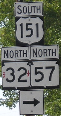
Photos by the numbers: 151

August 10, 2007: Wrong-way multiplex for US 151, WI 32, and WI 57 in Chilton, Wisconsin. This isn’t the only time 151 is contrary; in Cedar Rapids, US 151 and US 218 have a wrong-way triplex with US 30. The arrows on WI 32 are for the 32nd Infantry Brigade of the Wisconsin National Guard.

Posted in Sequences | Comments Off on Photos by the numbers: 151
Mar 31

A dose of thoroughly useless data

The east-west part of Chicago’s Dwight D. Eisenhower Expressway, aka “the Ike” or I-290, which turns into Congress Parkway in downtown, is about one mile north of the Monona/Harrison-to-Linn/Johnson county line. (About 41°51’N.) In fact, if you add five to longitude numbers in downtown Chicago, you will find yourself in southern Tama County along County Road E69.

Much of the Chicago metro area is in the latitudes between US 20 and I-80 in Iowa; US 20 dips southeast starting at Rockford to go into the city.

This isn’t particularly ground-breaking, but I was playing around with some numbers after I took the Jeopardy online test.

Meanwhile, this weekend Google is offering “8-bit mode” for “quests” like on on Nintendo games. These two characters are hiding north of the Chicago Loop.

Posted in Geography | Comments Off on A dose of thoroughly useless data
Mar 31

Photos by the numbers: 150

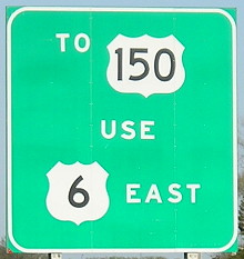
April 18, 2006: Guidance on I-280 approaching I-74. At a cloverleaf interchange on the south side of the Quad Cities, US 6 leaves I-74, then turns east at the airport, and then intersects US 150. US 150 used to go into Rock Island and end at least within sight of the state of Iowa, but the exact circumstances of its end are unclear. IA 150 was created in the hopes that it would become an extension of US 150, but it runs north-south instead of northwest-southeast line US 150. Now, of course, 150 has been removed completely from far eastern Iowa and ends in Vinton.

Posted in Sequences | Comments Off on Photos by the numbers: 150
Mar 30

Photos by the numbers: 149

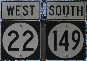
October 13, 2006: South English. Keokuk County has seven state numbers — 1, 21, 22, 23, 78, 92, and 149 — but no US routes. (It also had IA 77 until 2003.)

Posted in Sequences | Comments Off on Photos by the numbers: 149
Mar 29

Photos by the numbers: 148

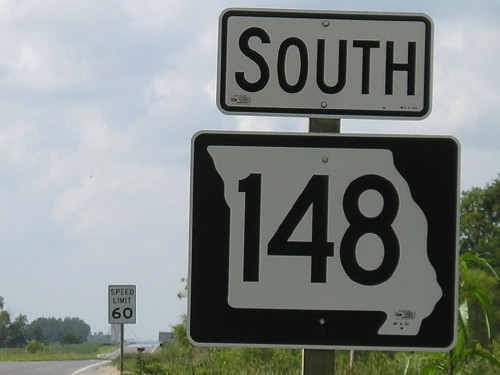
August 21, 2006: Sign at the Missouri state line, 13 miles north of its south end near Maryville. Even-numbered highways in Missouri conventionally run east-west, but this is an exception because it was created to continue from an Iowa number. It was MO 27 until 1968.

Posted in Sequences | Comments Off on Photos by the numbers: 148
Mar 28

March’s US 63 news

This was in one of the links of the map post, but I thought I’d break it out: The House approved a bill that would add the segment of US 63 between Ottumwa and Waterloo to the Commercial and Industrial Network. So far, the roads with this designation are identical to the ones enrolled in the National Highway System. All that a layperson would notice with this is that the rest of 63 would be red on the state map instead of black.

Meanwhile, although the Kirksville bypass is done, the 60-odd miles between there and Ottumwa will remain a bottleneck. KTVO has a report on some progress there — very, very preliminary progress. (I think they went a little overboard on the tagging under the video.) And Kirksville is already thinking about expected development on new 63 — so in 30 years we’ll have to do it all over again.

Posted in Construction | Comments Off on March’s US 63 news
Mar 28

Photos by the numbers: 147

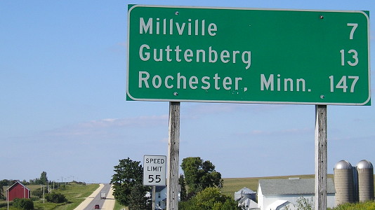
September 1, 2009: Rochester makes an appearance on this sign heading north out of Luxemburg. I am not sure it is the first. For the rest of its route in Iowa, US 52 will run through, out of, and around the high hills of the Driftless Area.

Posted in Sequences | Comments Off on Photos by the numbers: 147
Mar 27

Map Day!

The 2012 map went live online today.

Assorted sources report that the number of maps printed was cut nearly in half this year. This is not necessarily a bad thing as long as there are still enough. GPSs and smart phones won’t give you the size or large-scale detail you can get with paper. Each device has its place.

I haven’t scanned for corrections in a while, so it seems about time to re-check mileages around new four-lane segments.

(Ironically, in the first link above, Radio Iowa reports the DOT says that drastically cutting the number of maps printed will increase per-map costs.)

Posted in Maps | Comments Off on Map Day!
Mar 27

License plate countdown — ZGH

In addition, a Tama County YPK was printed in blue, meaning that YQA was the likely beginning of the black printing.

UPDATE 4/22: I was wrong. All it meant was that it was somewhere between YPK and YQA. Now I’ve seen a YPY (Webster) in black, so the exact point of switchover remains elusive.

Posted in License Plates | Comments Off on License plate countdown — ZGH
Mar 27

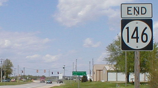
Photos by the numbers: 146

May 13, 2002: North end of IA 146 in Le Grand, pre-bypass. The straight-through alignment of US 30 through Le Grand existed throughout the second half of the 20th century. Between the intersection here and Montour, though, there is some discrepancy as to the true route of the Lincoln Highway:

  • The Lincoln Highway Map Pack uses T47 and the post-1954 alignment of US 30, running north then west from Montour to Le Grand, and never acknowledges the south alignment.
  • But the first state map, in 1919, uses E49 and two miles of what is now IA 146. That road was marked as IA 6 in 1920.
  • A Complete Official Guide of the Lincoln Highway (1924) also uses the latter route. The Lincoln angled off south of the point seen above to stay away from the railroad tracks. Later on, a bridge was built across the railroad tracks to the west, which stayed in use until 2004.
  • Marshall County put up a marker in 1925 on the south alignment.
  • The south alignment was the first US 30 and remained so until 1954.
  • When the DOT signed the Lincoln Highway in the early 2010s, the north alignment was signed as the main route while the south route was designated a loop. The signed route uses the necessary deviation of crossing the railroad tracks on new 30, but then goes through Le Grand and rejoins the four-lane east of town.

Since the picture at top was taken, 146 has been extended northward a fraction of a mile past the East Marshall athletic complex to new 30.

Posted in Sequences | Comments Off on Photos by the numbers: 146