Oct 04

Traer bridge once carried IA 58


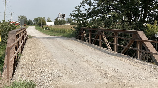
September 13, 2021: The 1st Street bridge over Coon Creek is used to get to the Traer airport, although “airport” is generous for the grass strip. In deep background is an old elevator damaged (I think) in the 2020 derecho.

The September Iowa DOT letting included a contract to replace the 1st Street bridge on the east edge of Traer. The contract was let by the state as part of the Federal-Aid Swap Policy, hence “swap” in the project code. (See also here.)

The bridge is a classic pony truss from 1914. This type faded out when the Iowa Highway Commission standardized reinforced concrete bridge designs in the 1920s. Those that remain are rapidly vanishing from rural roads, as even with low traffic numbers the structures are over a century old.

This particular bridge was once part of the Iowa highway system. Primary 58 used this bridge and road (170th Street) to head out of Traer toward Vinton until 1928. I am not 100% sure which street 58 used to switch from 2nd to 1st, though I presume it’s Taylor, the easternmost.

As early as September 1924, there was talk of getting a new route out of town, after a flood wiped out a bridge to the Chicago & North Western depot (the “Ole Depot”, extant today). The Traer Star-Clipper said the new road “would run from the Axon corner through the Sieh land and entering town on Second instead of First street.” Because the landowners in question are long gone, we must consult our friend the county atlas, the ancestor of our friend the plat book.

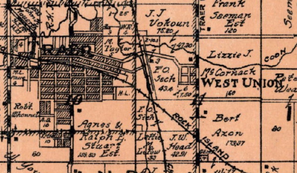
Here, we can see the first route east of Traer in an arc across the middle of this 1926 Perry Township map clip, along with the Sieh and Axon land. (The “town” of West Union was long dead, even in 1926, and is now a couple houses northeast of the North Tama Athletic Complex.)

The first of two realignments took the highway away from the 1st Street bridge. The new now-IA 8 was completed early in 1928, paralleling the Rock Island Railroad but then heading east on the half-section line through Section 11 (the line/road under the words “West Union”). The remaining diagonal to the bottom of Section 11 and then east didn’t come until 1941.

The 1st Street bridge will be replaced next spring, in its 108th year.

Posted in Tama County | Comments Off on Traer bridge once carried IA 58
Oct 01

Louisa County stops paying the ferryman

The distinction between farm-to-market and local roads once mattered to a great degree in highway systems. Even now, the designation is maintained, and the former is described as roads that “provide all-weather routes to destination points”. So when a county wants to “demote” and “promote” its roads, the state still has to give approval.

Louisa County did some of this recently. From the Burlington Hawk Eye:

The 5.5 miles proposed to be removed from the FM system will include a combined section of County Road X71/River Road northeast of Oakville. The road originally provided access to the ferry that operated between Louisa County and New Boston, Illinois, until it ended operations about 45 years ago.

Unpaved X71 is marked on the Louisa County map, dead-ending at the mouth of the Iowa River. It’s also shown as an FM road on this FM-specific map from 2011 that shows X61 on the Great River Road not quite finished yet.

In 1948, the Cedar Rapids Gazette said the ferry service was 130 years old, which would date it back to approximately Illinois’ statehood. The operator expected to end the service that winter, but something must have happened to keep it going. A short item in 1952 said thieves stole two of three ferry boat motors, and gave a different name for the operator.

A 1979 Gazette article referring to “the old ferry landing” leads with a historical nugget about the Cedar River: Its abrupt turn southwest at Moscow to Columbus Junction is based on ancient stream beds of the Mississippi on the west edge of the Illinoian Glacier. (Note the small incursion of the glacier into southeast Iowa on this map.)

The Hawk Eye article says part of the local/FM balance will be maintained by adding G36 southeast from X17 to Columbus Junction, which is currently unpaved. The rest of the addition is one mile of gravel from Oakville along the Iowa River to X99. This segment was part of IA 99 until a slight bypass of Oakville was built in 1955. The bypass itself was graded in 1941 according to the DOT document archive, and the 1945 county map shows “F.A.” for Federal Aid on the 1¼-mile bypass curve, but I seriously doubt the dirt road would have been signed as 99 at that time. At the very least, it was 99 in 1931-41.

(Title reference.)

Posted in Highway Miscellaneous | Comments Off on Louisa County stops paying the ferryman
Sep 29

Bella Vista bypass opens this week

One of the Midwest’s longest-promised highway projects that never seemed to get off the ground for years is opening this week.

The Bella Vista bypass will go across the Arkansas-Missouri state line and create a full four-lane I-49 from Fort Smith to Kansas City. Stories: KATV, KHBS.

The ribbon-cutting will be Thursday, and the interstate will be open Friday.

Posted in Highway Miscellaneous | Comments Off on Bella Vista bypass opens this week
Sep 28

It is the children who are wrong

The Verge: 

Gradually, Garland came to the same realization that many of her fellow educators have reached in the past four years: the concept of file folders and directories, essential to previous generations’ understanding of computers, is gibberish to many modern students.

But if students don’t understand directories, how can they create folders to hold images for their … oh, right, no one makes websites anymore.

Heaven help us if they ever encounter a C:\ prompt.

“As much as I want them to be organized and try for them to be organized, it’s just a big hot mess,” Vogel says of her files. She adds, “My family always gives me a hard time when they see my computer screen, and it has like 50 thousand icons.”

I think my brain just kernel panicked.

Posted in Uncategorized | Comments Off on It is the children who are wrong
Sep 27

Notes on first 2020s redistricting map

So, I didn’t win Redistricting Powerball. Oh well. Ironically, my very first map based on 2019 population estimates — and, to a lesser extent, Mock 21 — came closest to pegging the new 1st District. The overall variance is 99, slightly better than my 151 in Mock 23. Here’s the link to the LSA site.

IMO, it’s misleading to treat “old” and “new” districts with any sort of continuity. The “new 1st” retains only two counties of the old 1st, Linn and Jones. Despite that, the 538 website managed to mis-assign Ashley Hinson to the new 2nd and Mariannette Miller-Meeks to the new 1st. (MMM is at the very bottom of the new 2nd.) However, because of the nature of Iowa districts, it’s easy to compare county clusters, and their previous statewide-election partisan breakdowns.

From a map perspective, it’s very interesting to draw comparisons with the third 1981 proposal, the first set under the new system and only one so far to go to a third map.

  • Anything with Linn and Johnson together creates a district friendly to Democrats. And, as John Deeth points out, “Johnson and Linn are a self-contained unit of 12 House and 6 Senate districts.” That’s basically half a congressional district.
    • But then, if “split Linn and Johnson” is an unspoken wish/demand from the Legislature, and it’s the one thing the LSA won’t/can’t do, it could get ugly. My Mock 14, 17, and 17A each fit the bill, but with variances in the hundreds, and Iowa Code specifically states that the second plan cannot be worse.
    • One of the photos on Page 33 of this report looks awfully familiar
  • The only other “self-contained unit” runs across 14 counties at the Minnesota border — but contain only 6 House/3 Senate districts.
  • Polk and Dallas counties make up three-quarters of the population in the proposed 3rd Congressional District.
  • Senate Districts 7 (all or part of Madison, Adair, Guthrie, Greene counties, plus half each of Carroll and Dallas) and 47 (Camanche to Peosta) are the two congressional-district jumpers.
  • Tama County and Wapello County (Ottumwa) have only been together in a congressional district twice before: the 1860s and the 1960s.
  • Tama County’s proposed state House district is remarkably similar to its 1990s House district, with northern Benton County and part of Black Hawk. However, this time, the companion district is southwest to Marshalltown instead of southeast to Iowa County. Each House district can keep a current representative (Dean Fisher of Garwin, Sue Cahill of Marshalltown).
  • Tama County’s proposed state Senate district would be an open seat in 2022.
  • In the 1980s, Mason City, Burlington, and Clinton were all just a smidge too big to be their own House districts (as were Marshalltown and Fort Dodge in failed maps). Now, though, each needs to pull in surrounding areas to create one. Council Bluffs and Dubuque were each “two plus a little” and remain roughly so.
  • Have I mentioned Waukee’s city limits are outrageously absurd? Because Waukee’s city limits are outrageously absurd. Ditto for Carlisle.
  • Ankeny now has an entire state Senate district to itself, and Marion makes up 3/4 of one. (And have I mentioned Ankeny’s south city limits are outrageously absurd? Did the Census Designated Place of Saylorville set up a force field?)
  • Coralville and North Liberty, plus a bit of Iowa City, pretty much make up a Senate district as well. This ends the greatest political buddy comedy that never happened, a pairing of Republican Bobby Kaufmann and his state senator, Democrat Zach Wahls.
  • Proposed House 39 and present House 40 are identical: Urbandale, minus a chunk between 72nd and 86th streets. In the 1980s, one House district could hold Clive, Urbandale, and Windsor Heights.
  • Follow IA 4 and IA 25 from top to bottom and you’ll only hit four state Senate districts.
  • Extremely tangential note: Jefferson County did NOT surpass its 1870 population. In fact, it hit its lowest population since 1940. Only part of that is due to Maharishi Vedic City appearing to nearly vanish, losing 1000 people from 2010.
  • Anyone say anything about Illinois? Does the New York Times know the Illinois Legislature exists?
Posted in Maps | Comments Off on Notes on first 2020s redistricting map
Sep 24

Third loop at I-80/380 going away


March 12, 2007: When IA 27 was created, signs on I-80 were retrofitted with mini-shields to save space. It’s this exit that will be going away next week. The Tiffin exit will serve as the turnaround.

The first loop ramp to go at the I-80/I-380 interchange was the most important one, eastbound 80 to northbound 380. The second was northbound US 218 to westbound 80.

Monday night, a third loop is being closed permanently: westbound 80 to southbound 218. Both it and the previous loop closure will require going past the interchange to the next exit (Forevergreen Road and the Tiffin exit, respectively) and turning around.

Both exit movements will not be restored until the end of the 2023 construction season, a full two years-plus from now.

The only loop remaining after next week is southbound 380 to eastbound 80.

Tuesday morning, the “exit point” from westbound 80 to northbound 380 will be moved ¼ mile east, closer to the Coral Ridge onramp and approximately at 80’s bridge over US 6 and the railroad based on the DOT’s explanatory map.

Posted in Construction | Comments Off on Third loop at I-80/380 going away
Sep 22

It’s 941, not 939

I should have said something earlier. I should have said it when I made a post about it.

The two Nebraska students who visited “all 939” towns in Iowa this summer — and got another article in the Register — MISSED TWO OF THEM. But I can’t tell them directly, because I don’t do Facebook, and there’s no way for me to know which two fell off their list.

The 2020 census numbers, directly from the State Data Center, show that on April 1, 2020, there were 942 incorporated places in the state. Pioneer, in Humboldt County, was formally disincorporated in August, so right now there are 941 incorporated places, not 939. This number matches previous posts I’ve done about cities that disincorporated.

I cannot link to the 2020 population list because the State Data Center does an interactive thing that requires changing parameters. (It should not be hard to get raw data!) I can, however, link to my PDF from 2011 that clearly shows there were 947 cities at that time. That’s the list I used, crossed with the state map, on my quest that ended in 2016. Six have been discontinued since.

But I have to say something somewhere, because there are 941 cities in Iowa in 2021, no matter what their book title says.

Posted in Iowa Miscellaneous | Comments Off on It’s 941, not 939
Sep 20

Razing 1917 building an option for North Tama

WAIT WHAT


July 7, 2021: North Tama’s 1917 school building, as seen from 7th Street in Traer. The concrete steps to the door are relatively new and used to have tannish-orange edges like you see lining the bottom of the bricks. The windows were replaced in 2010, and the entire complex got air conditioning of some sort in 2015.

It started as an innocuous forward-looking press release in March. “North Tama School officials recently announced that the district will engage in a formal process to ensure the district’s facilities are equipped to meet the needs of students in the coming decades.”

Then, three weeks ago, things really ramped up.

Closing Walnut St, razing 1917 building among the options considered at North Tama special board work session

WHOA. This was definitely not on my radar. As usual, never assume I’m in the loop; in fact, assume I am unaware of the existence of the loop.

The North Tama Telegraph says the options have been narrowed to three. Two would involve the permanent closure of Walnut Street, which I don’t particularly like, for new elementary construction to the west. Two would result in the demolition of the core 1917 building — the three-story structure plus the present cafeteria and expansive Family and Consumer Sciences area. (Ironically, none appear to include acquiring the property at 606 Main St. that blocks filling the block.) A video recording of the meeting is available here: Plans 2, 4, and 6 are the ones advancing.

None of the three plans currently include an auditorium or a new competition gymnasium to augment the 65(!)-year-old one, which would become the oldest part of the complex. A true auditorium has been a dream of some in the community for decades, perhaps ever since the one integrated into the 1917 building was chopped up into classrooms.

Imagine baking multiple cakes in pieces of various shapes and heights, sealing them together with frosting, and then trying to cut the tallest portion plus another chunk of the center out without disturbing the rest of the cake. That’s what we’re talking about when it comes to the 1917 building in Traer. The closest parallel I can think of is Newell-Fonda announcing earlier this year it’s considering demolition of its original core building. When Hudson did it two decades ago, the oldest structure was basically a corner piece.

Construction of the 1917 building, which opened in the fall of 1918 and was dedicated January 31, 1919, had a larger than expected cost: $105,000. “The prices of everything these days are abnormally high,” the Traer Star-Clipper said July 6, 1917. After all, there’s a war on.

The gym addition with stage, band room, and locker room cost $227,000 ($185,000 bond plus cash on hand, opened winter 1955-56); the elementary plus stuff east of the gym cost $500,000 in 1963 (opened 1964). Another $500,000 bond issue in 1979 formed the FCS area (then “home ec”) over the original gym-turned-cafeteria and added an industrial arts area — after a $1 million version including an auditorium was shot down twice. A $380,000 bond issue in 1996 cleared the way for the multipurpose room and kindergarten on the north side in 1997. There are also minor additions to the south (1940) and north (1957) sides of the original gym/cafeteria before the large 2010 expansion on the north side.

The two more extensive options in the 2020s, which would take down the 1917 building and replace it with a single-story addition, are currently estimated to cost between $30 million and $35.5 million. I would miss it very, very much; after all, it’s what kindled my love and respect for that style of building. I’m in the group of rural Iowans that has not known either consolidation or building loss in my home district since graduation. Removal of the oldest part of the school, one generations have known inside and out, would be a gigantic change for everyone. Will I need to hug it goodbye?

(Sources: Cedar Rapids Gazette, 10/10/54, 12/18/55, 3/12/57, 1/7/63, 9/10/78, 3/4/92, 6/26/96; Waterloo Courier, 2/15/78, 5/20/79; Traer Star-Clipper, 6/15/17, 7/6/17, 1/31/19, 8/16/40)

Posted in Schools, Tama County | Comments Off on Razing 1917 building an option for North Tama
Sep 18

Go Big … Black?

[rant]

WHY IS NORTH TAMA WEARING BLACK PANTS

BLACK IS NOT A NORTH TAMA COLOR

WHY CAN’T ANYONE WHO DOESN’T HAVE BLACK AS A SCHOOL COLOR BE HAPPY WITH THEIR UNIFORMS

[/rant]

But hey, big Homecoming win.

Posted in Sports, Tama County | Comments Off on Go Big … Black?
Sep 17

School timeline mega-update: 1968-70, plus compilations


August 16, 2016: “There will be an informal opening of the new gymnasium at the Sharpsburg school on Saturday evening, October 10, at 8:00 o’clock [sic]. A snappy program is planned, followed by a lunch consisting of sandwiches, pie, pickles and coffee.” — Lenox Time Table, October 8, 1936

“The exodus of high school graduates from the county has become so universal that Mount Ayr high school seniors were given a special guest lecture this year on urban living.” — Des Moines Register, May 24, 1970

Everything Many things you wanted to know about the United and Mount Ayr community school districts, but didn’t know how to ask:

  • It took the United Community School District, between Ames and Boone, TEN bond issue votes before finally getting a centralized building in January 1968 (Ames Daily Tribune, 12/15/64).
    • United started as a merger between Jordan and Napier (ADT, 4/16/55) and added Luther in 1957 (ADT, 5/1/57).
    • I believe the Luther school closed at the end of the 1967-68 school year, and students moved to Jordan. It was gone by fall 1969 for sure (ADT, 9/5/69).
    • In between approving a bond issue for a new high school and it actually opening, voters scuttled a tripleheader East Boone merger with Boone and Madrid (ADT, 4/6/66).
    • Then another bond issue for an elementary addition (ADT, 11/16/71) replaced Jordan and Napier by fall 1973 (ADT, 10/12/73) …
    • … three years before everything in Jordan was wiped off the face of the earth by a tornado a mile wide, one of two F5s in Iowa in the Fujita scale era and notorious for being caught on film spinning counterclockwise.
  • Nichols, like Atkins, existed independently after mid-1966 because of litigation. A “long series of legal actions related to an attempt to reorganize the Nichols District” (Lone Tree Reporter, 1/11/68) meant that the school remained independent for two extra years. Lone Tree’s attempt to get at least part of the district failed and Nichols went to West Liberty (LTR, 8/29/68).
  • Sharpsburg’s school closed on February 2, 1968 (Lenox Time Table, 2/1/68). It followed a dizzying array of bond issue votes, including multiple ones between December 1962 and November 1963, that eventually led to a new high school building in Lenox and all elementary grades moving to the old school there.
    • Two rural school buildings — Grant No. 4 in Adams County and Grant No. 3 in Taylor County — were brought in and placed right next to the Sharpsburg gym in 1965 so Lenox could stop renting space in the American Legion building. “The board emphasized that this was a temporary measure.” (LTT, 7/8/65) They remain there to this day and can be seen from old IA 49.
    • Yes, Adams and Taylor County both have Grant Townships, separated only by Platte Township in the northeast corner of Taylor County.
  • Schools in Joice, Hayfield, and Leland all closed in 1968 (Forest City Summit, 5/2/68 and 5/16/68). Leland was torn down the following spring (FCS, 3/27/69, and personal visit to site)
    • Leland’s gym was 18 years old (FCS, 3/27/69). Hayfield’s elementary addition was 16 years old (FCS, 4/5/51). Joice’s elementary addition was 9 years old (FCS, 3/19/59).
  • Beaver’s school closed at Christmas break in 1968, two years after being assigned to Ogden (The Globe-Free Press and Paton Portrait and Rippey News, 1/9/69)
  • Morley’s school closed in 1968 (Anamosa Journal, 2/26/68)
    • Its second-to-last news item was about a boy injured by flying glass during a storm on the same day as the Charles City tornado (AJ, 5/20/68). Its last news item was the city of Morley taking it over and demolishing the main building to leave the gym as a community center (Anamosa Eureka, 6/18/70).
    • The Martelle, Morley, and Viola districts were all cut up in 1961-62, with Anamosa getting the towns and other districts getting land.
  • Rhodes’ school closed in 1969 (State Center Enterprise, 4/24/69). The West Marshall board voted and rescinded the move in the same meeting a year earlier (SCE, 3/14/68). Finding this took a little extra work as the SCE’s images for 1969 are so illegible only headlines get picked up by the digital reader.
  • Grant’s school closed over Christmas break in 1969-70 as students moved to a new building in Griswold (Griswold American, 1/7/70).
  • The school in Farson, an unincorporated village 10 miles west of Packwood, closed in 1970 (Richland Clarion, 1/15/70)
  • Ringgold County, all presently part of Mount Ayr (formed 1958):
    • Beaconsfield’s school closed in 1960, two 1961, three years after its last high school class (IAGenWeb)
    • Redding’s school closed in 1970 (IAGenWeb)
    • Maloy’s school closed in 1972 (IAGenWeb)
    • Tingley’s school closed in early 1980 and was demolished in late 1980 (IAGenWeb)
    • The school in Benton (a small town on IA 2) was demolished in 1982 (IAGenWeb), but its closure year is ambiguous. Mount Ayr was using it for sixth-graders at least through 1977 (IAGenWeb). Mount Ayr passed a bond issue in early 1979 (Des Moines Register, 2/14/79) so I assume Benton closed in spring 1980, when an addition opened, along with Tingley.
    • Said bond issue came after a state inspector condemned the oldest part of Mount Ayr’s complex in November 1977 and classes were scattered in other buildings throughout town (DMR, 2/19/79) …
    • … and also sent to the Ellston school. Despite being the newest building in the district it had been officially closed in 1970 (DMR, 7/12/70) but got junior high back for a few years (DMR, 2/1/78). It probably closed again in spring 1980.
    • Delphos’ school was demolished in 1991 (IAGenWeb)
    • The 1936 portion of the Mount Ayr school was demolished in 2010 (Mt. Ayr Record News via IAGenWeb)
  • The Harlan Community School District, which added towns in the western half of Shelby County, formed by vote in 1966 (Harlan Tribune, 6/23/66). Four towns — Defiance, Earling, Panama, and Portsmouth — kept kindergartens but ONLY kindergartens until sometime after 1970. I don’t have an end date because Harlan archives end that year right now.

UPDATE 1/21/22: Adjusted Beaconsfield based on new information.

UPDATE 5/12/25: Closure of both Benton and Tingley in 1980 confirmed via Record-News, 4/17/80 and 5/15/80. But Ellston was only used for one year, and a fraction of a year at that, before classes were moved to the basement of the otherwise-demolished 1912 building in Mount Ayr (4/13/78).

Posted in Schools | Comments Off on School timeline mega-update: 1968-70, plus compilations