| Longer than 2 miles | Signed | Active | July 1, 2003 |
| No. | Year(s) | Old/Co. | Length | Proof of life | Other notes |
| 964 | 1978 -1981 -1986 -1996 |
IA 92 Marion |
12 (1980) 8 (1981) 4.7 (1986) |
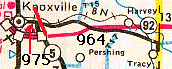 1981 1981 |
Old IA 92; last part now Bus. 92, MMs 1 and 2 still up; on DeLorme |
| 965 | 1976-1980 |
US 52 Winneshiek |
3.3 | Jason
Hancock's research: "US 52 intersects 3 times" Bypassed segments at W34 and through Burr Oak |
|
| 965 | 1985
(-1990) (-1994) (-spring 2003) (-July 1, 2003) |
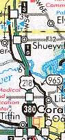
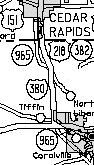
US 218 Linn/ Johnson |
17.8 (1985) 16.3 (1990) 13.79 (2003) |
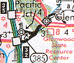
Originally extended up to US 30, was 218 (rerouted after IC bypass done), 6th St. north of there and 16th Ave. became 941 in 1981; now only extends to 76th Ave. C.R. Gazette reported part N of F12 taken over by Cedar Rapids in spring 2003 |
Perhaps most famous "secret" road; poss. first signed Broken after N. Liberty's segments turned over until 2003 |
| 966 | 1976 -1995 -1996 |
IA 416 Dubuque |
4.9 (1980) 0.4 (1995) |
 1995; see also 963 map
 |
All of 416, then in Centralia city limits |
| 967 | 1976-2003 |
US 20, then IA 418 Dubuque |
0.04 (211 ft., ca. 70 yds.!) |
"From eastbound 20, there is a turnoff for Farley's industrial park at the same time you see the first BGS for the Y13 interchange. After turning left, there is a sharp turn to the right, and once you're there you'll come to a DOT-style Farley city limit sign right next to the Sinclair station. The pavement changes at that point, and that's where 968 ends." |
Football players have runs longer than this road, just west of Farley |
| 968 | 1968-1989 |
US 20, then IA 420 Dubuque |
2.4 | Old 20; was 947 W of Dyersville | |
| 968 | 1994 -1995 -1996 |
IA 163 Marion |
5.4 (1994) 1.1 (1995) |
 1995 1995
 2001
DeLorme 2001
DeLorme |
Last part btwn. 102 and new 163; now Bus. 163 |
| 969 | 1976-1980 |
IA 422 Kossuth |
0.5 | Jason Hancock's research: "US 169 to WCL Burt" | Still marked as 422 thru 1980 map |
| 969 | 1993-1994 |
US 218 Bremer/ Black Hawk |
3.4 | Jason Hancock's research: "From US 218 south of Waverly to jct. of US 218 and C57" | Through Janesville; now V14 |
|
475 and 970 |
(1969) 1975 |
US 75 Woodbury/ Monona |
31.8 (1975) 17.2 (1980) 12.8 (1983) 12.5 (1994) 50m (0.03, ca. 164 ft. or 34.667 yards) (2003) |
Only in Woodbury County after '80; city portions turned over '83; '94-'96 "skip between US 75 south of Singing Hills Drive (current S end) and Warrior Drive in Sergeant Bluff"; listed in metric 1996; see big map below
|
See big map at bottom for all of 475/970 (and 982) Just S of what is now Bus. 75; very, very small piece |
| 971 | 1975-1979 |
IA 2 Fremont |
10.8 | Ended just N of 48's S end | |
| 971 | 1993 -2001 -2003 |
IA 105 Winnebago |
1.8 | 
 1999 1999Remained active inside city limits until 2003 |
Marked on maps 1997-99 |
| 972 | 1969-1974 | US 218 Henry |
2 | Iowa DOT online records In 1974, state apparently accidentally designated a second IA 972 (below); they were both renumbered November 13 of that year. |
|
| 972 | 1974 | US 34 Mills |
2.77 | Iowa DOT online records Designated February 6, 1974; renumbered IA 978 |
|
| 972 | 1976-1980 |
US 169 Madison |
10.2 | 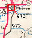 1977 1977 |
N-S road old 169; E-W road (in red square) old 92 |
| 972 | 1993-2003 |
IA 105 Worth |
2.0 | 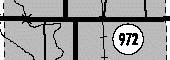
|
2 miles exactly through town |
| 973 | 1969-1971 | US 75 Pottawattamie |
1.8 | Iowa DOT online records Turned over to city; later reinstated as part of IA 192 |
|
| 973 | 1972-1973 | US 6 Cass |
10.1 |  1973 1973 |
Became extension of IA 83 |
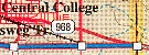
| 973 | 1976 -1978 -1980 |
IA 92 Madison |
1.5 | See Madison 972 map (above). Section inside Winterset turned over before county. | |
| 973 | 1993-2001 |
IA 105 Mitchell |
0.65 | 
Segment inside St. Ansgar |
All three counties called road "Co. 105" or "Hwy. 105" after decom'd |
| 974 | 1965-1980 |
US 30, then IA 94, then IA 150 Linn |
5.09 |  1977
1977 |
Part of original Lincoln Highway |
| 975 | 1964-1974 | IA 411 Iowa |
1.33 |  1974
1974 |
On 1975, 1976 maps |
| 975 | 1978-1986 |
IA 5 Marion |
4.7 |  1986
1986 |
Section of Knoxville road that was IA 5, now Bus. 92 |
| 975 | 1995-1996 |
US 275/ Fremont |
0.13 (686 ft., ca. 229 yds.) | Jason
Hancock's research Nishnabotna River to former east/south junction of US 275/IA 333 |
Near Hamburg |
| 976 | Mid-1970s -1981 |
US 218 Henry |
2 |
Jason Hancock's research: "US 218 to NCL Mount Pleasant" |
1st route of 218; 2nd rte. (bypass) now bypassed |
| 976 | 1996-1997 |
US 30 Marshall |
0.2 (1056 ft., ca. 352 yds.) | Jason Hancock's research: "ECL Marshalltown to end of route" | E'most part of old 30 |
| 976 | 1997-2003 |
US 30 Marshall |
0.87 |   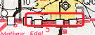 2001 2001 |
Jason Hancock says only part that is truly 976 is more or less the on and off ramps to 30 (I thought it was all of old 30) |
| 977 | 1962-2003 |
IA 3 Cherokee |
2.01 | 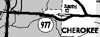
|
Hwy. 3 until it was aligned on a diagonal |
| 978 | 1962-1964 | IA 44 (15) Kossuth |
1.39 | 1962 traffic count book, via Alex Latham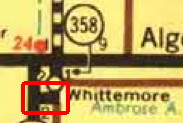 1963 1963 |
IA 44 and 358 were swapped; 358, originally a bypass of Whittemore, became a spur |
| 978 | 1974-2002 |
US 34 Mills |
2.77 | 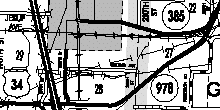
  2001 2001 |
Part btwn. 385 and 34 taken over by 385; Mills Co. agreed to take 385, 949, 978 Dec. 30, 2002 |
| 979 | 1962 (-1980) (-1987) -2003 |
IA 1 Johnson |
17.4 (1964) 6.2 (1980) 4.33 (2003) |
 1977 1977 |
E of I-80; Cedar Co. decom'd in 1980; IC to I-80 decom'd in 1987 |
| 980 | 1962-1981 |
US 34 Wapello |
0.8 | Jason
Hancock's research: "US 34 to WCL Ottumwa" Western part of Old/Business US 34 (Albia Road) |
|
| 981 | 1967-1980 |
IA 150 Fayette |
0.4 | Was
IA
991, got renumbered |
|
| 981 | 1995-1996 |
US 34 Jefferson |
0.25 | Jason Hancock's research: "Old US 34 through Batavia" | |
| 982 | 1961 | IA 136 Jones |
0.3 | 1962 traffic count book, via Alex Latham Bypassed fraction of Buchanan Street on the south side of Cascade |
|
| 982 | 1967-2003 |
IA 141 Woodbury |
27.78 | 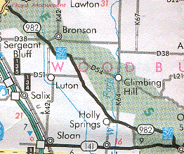 2001 2001 |
Sioux City limits to Smithland limits; ends just short of 141; does not reach 20 either; also see 1981 map below |
| 983 | 1962-1963 | IA 213 Monroe |
1 | 1962 traffic count book, via Alex Latham 1963 1963 |
|
| 983 | 1967, 1976 -1980 |
US 34 Lucas |
0.5 (1967) 0.8 (1977) |
Jason
Hancock's research Old/Business US 34 outside of Chariton city limits; later the portion west of Chariton was added |
|
| 983 | 1997-1998 |
IA 5 Polk |
0.2 (1056 ft., ca. 352 yds.) | Jason Hancock's research: "Market Street to end of route in Carlisle" - now frontage road | |
| 984 | 1968-1982 |
IA 417 Scott |
2.2 | Jason Hancock's research: "NCL Bettendorf to Le Claire (was US 67, later IA 417)" | Not marked as "unmarked primary" |
| 985 | 1961-1963 | US 63 Mahaska |
1 | 1962 traffic count book, via Alex Latham Lynndale Avenue, just north of Oskaloosa; separate fragment just north and west of RRX was bypassed no later than late 1930s. The 985 segment and other segment were both slightly lengthened when new railroad overpass for US 63 was built in 2008. |
|
| 985 | 1969-1973 | IA 7 Woodbury |
5.3 (approx.) | 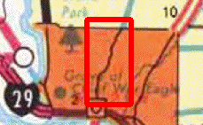 1972
1972Old IA 7, which had been original IA 29, in Sioux City (route was removed in 1969) |
|
| 985 | 1980-2003 |
US 52 Jackson |
1.92 | 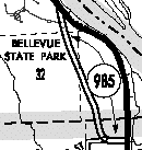 
 2001 2001Transferred to the state Oct. 1, 1980; never paved |
SE of Bellevue |
| 986 | 1969-1986 |
US 75 Monona |
4.9 |  1981 1981 |
IA 301 to county line |
| 987 | 1962-1963 | US 63 Black Hawk |
4.45 | 1962 traffic count book, via Alex Latham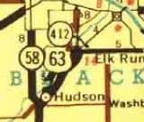 1963 1963Eldora Road (old 63) from NCL Hudson to San Marnan Drive |
|
| 988 | 1962-1963 | US 63 Black Hawk |
0.16 | 1962 traffic count book, via Alex Latham SCL Hudson to new junction of 58/63 just south of Hudson |
|
| 988 | 1975-2003 |
none (Neb. 36) Pottawatt. |
2.31 | Signs on I-29 only | |
| 989 | 1962-1963 | US 34 Monroe/ Wapello |
17.76 | 1962 traffic count book, via Alex Latham 1963 |
|
| 990 | 1962-1963 | IA 150 Fayette |
0.27 | 1962 traffic count book, via Alex Latham North part of Fayette bypass |
|
| 991 | 1962-1967 | IA 150 Fayette |
0.4 | 1962 traffic count book, via Alex Latham South part of Fayette bypass |
Became IA 981 |
| 992 | 1961-1963 | US 18 Hancock/ Kossuth |
8.81 | 1962 traffic count book, via Alex Latham ECL Wesley to WCL Britt 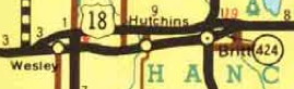 1963 1963 |
|
| 993 | 1961-1963 | US 18 Hancock |
3.52 | 1962 traffic count book, via Alex Latham From a mile west of IA 226 (today a segment marked "No Snow Removal") to WCL Wesley (see above) |
|
| 994 | 1961-1967 | IA 141 Woodbury |
27.78 | SEE IA 982, above | Became IA 982 |
| 995 | 1961-1967 | US 34 Lucas |
0.5 | Iowa DOT Primary Route Description files Old US 34 from ECL Chariton to US 34 |
Became IA 983 |
| 996 | 1961-1976 | US 34 Lucas |
0.3 | Iowa DOT Primary Route Description files Old US 34 from WCL Chariton to US 34 Incorporated into IA 983 |
|
| 997 | 1960-1961 | IA 5 (IA 7) Webster |
0.89 | Iowa DOT Primary Route Description files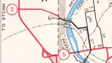 1961 Ft.
Dodge 1961 Ft.
Dodge |
|
| 998 | 1961-1994 |
US 61 Lee |
0.67 | Jason
Hancock's research: "US 61 to NCL Montrose" See also Iowa DOT Primary Route Description files |
Became IA 924 |
| 999 | 1948-1951 | IA 333 Page |
8.24 | Through College Springs; not shown on state maps | |
| 999 | 1951-1973 | IA 333 Page |
5.70 then 5.52 | Not
through College Springs; not on state maps until 1961 renamed Alt 333 before 1959 (1/1/60) book, back to 999 in 1962, traffic books said 333A until 1970 |
|
| 999 | 1973-1980 |
IA 333 Page |
2.52 |  1977
(far
left) 1977
(far
left)This is 999 in the late 1970s books. 1974 is first state map to have 333 marker SE of College Springs |
 2001
2001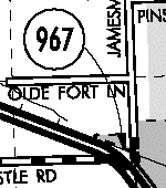 How
do you get there? Jason
Hancock:
How
do you get there? Jason
Hancock: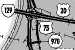 I
don't see it.
I
don't see it. 1600 percent zoom!
UNUSED NUMBERS (past and present): 900-902, 905-911
Old 34 west of Ottumwa, old IA 150 south of Fayette, the pre-2003 route of IA 982, and old US 34 east of Chariton were renumbered in 1967 "due to a conflict with the accident coding procedures of the Department of Public Safety." Aside from 988, no number above 986 was recycled, even if it was gone by 1963.
Big Maps:
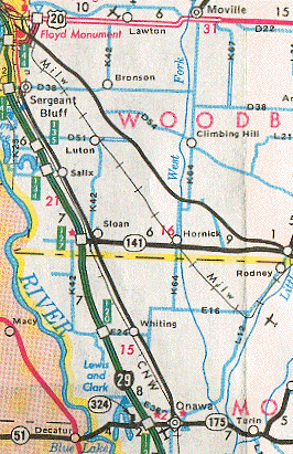
1981 map: 970 (Sioux City-Onawa); 982 (SC-Smithland)
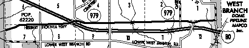
2002 Johnson County. Note that the road west of I-80 is not 979, but Herbert Hoover Highway